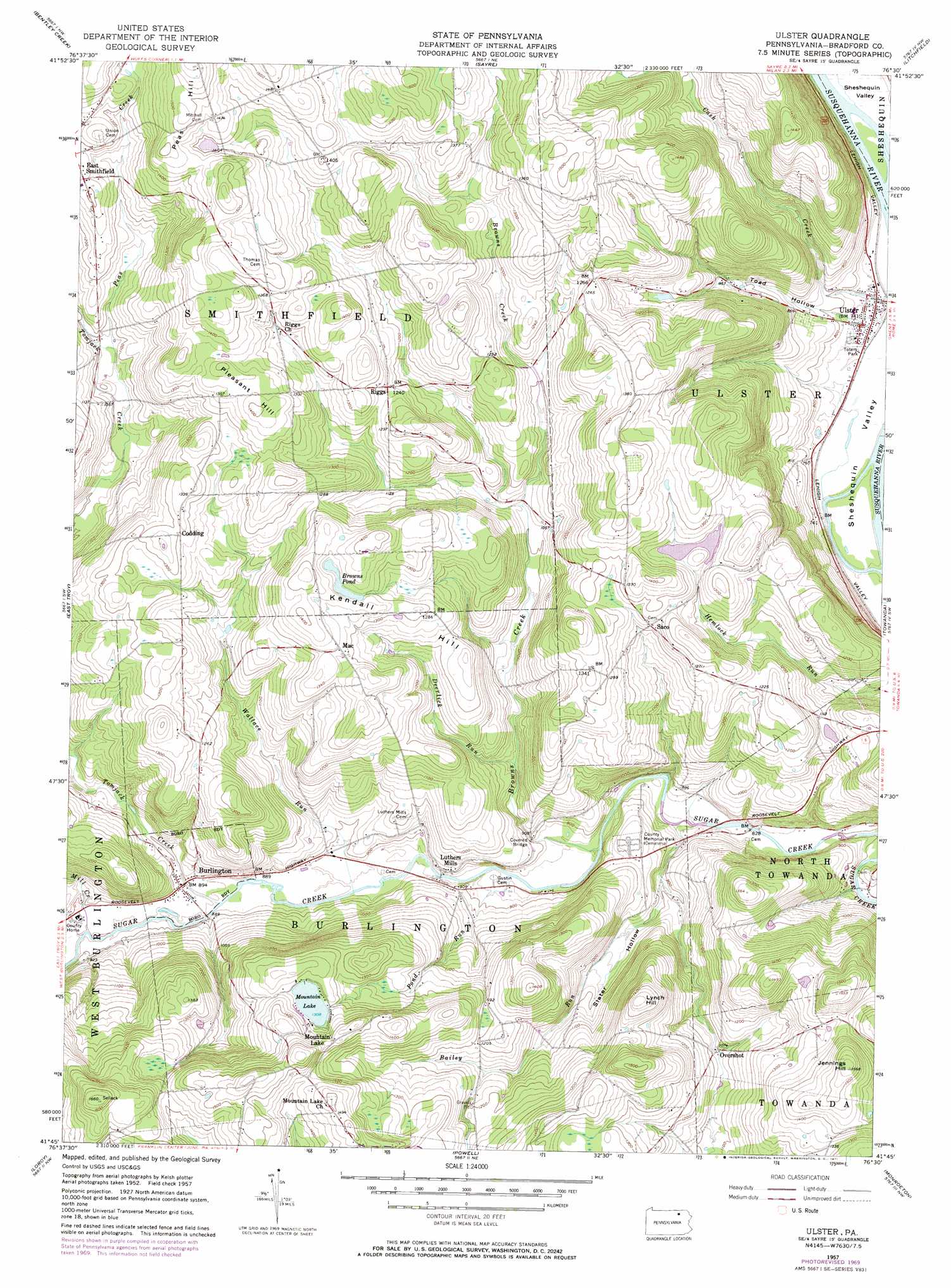
Ulster Topo Map Pennsylvania
To zoom in, hover over the map of Ulster
USGS Topo Quad 41076g5 - 1:24,000 scale
| Topo Map Name: | Ulster |
| USGS Topo Quad ID: | 41076g5 |
| Print Size: | ca. 21 1/4" wide x 27" high |
| Southeast Coordinates: | 41.75° N latitude / 76.5° W longitude |
| Map Center Coordinates: | 41.8125° N latitude / 76.5625° W longitude |
| U.S. State: | PA |
| Filename: | o41076g5.jpg |
| Download Map JPG Image: | Ulster topo map 1:24,000 scale |
| Map Type: | Topographic |
| Topo Series: | 7.5´ |
| Map Scale: | 1:24,000 |
| Source of Map Images: | United States Geological Survey (USGS) |
| Alternate Map Versions: |
Ulster PA 1957, updated 1958 Download PDF Buy paper map Ulster PA 1957, updated 1971 Download PDF Buy paper map Ulster PA 1957, updated 1971 Download PDF Buy paper map Ulster PA 2010 Download PDF Buy paper map Ulster PA 2013 Download PDF Buy paper map Ulster PA 2016 Download PDF Buy paper map |
1:24,000 Topo Quads surrounding Ulster
Elmira |
Wellsburg |
Waverly |
Barton |
Owego |
Gillett |
Bentley Creek |
Sayre |
Litchfield |
Windham |
Troy |
East Troy |
Ulster |
Towanda |
Rome |
Canton |
Leroy |
Powell |
Monroeton |
Wyalusing |
Grover |
Shunk |
Overton |
Dushore |
Colley |
> Back to 41076e1 at 1:100,000 scale
> Back to 41076a1 at 1:250,000 scale
> Back to U.S. Topo Maps home
Ulster topo map: Gazetteer
Ulster: Lakes
Browns Pond elevation 397m 1302′Ulster: Parks
Totem Park elevation 226m 741′Ulster: Populated Places
Burlington elevation 272m 892′Codding elevation 395m 1295′
Luthers Mills elevation 271m 889′
Mac elevation 405m 1328′
Mountain Lake elevation 433m 1420′
Overshot elevation 324m 1062′
Riggs elevation 378m 1240′
Saco elevation 376m 1233′
Ulster elevation 227m 744′
Ulster: Streams
Bailey Run elevation 249m 816′Browns Creek elevation 254m 833′
Deerlick Run elevation 276m 905′
Mill Creek elevation 268m 879′
Peas Creek elevation 327m 1072′
Pond Run elevation 260m 853′
Spaulding Creek elevation 224m 734′
Tomjack Creek elevation 268m 879′
Wallace Run elevation 261m 856′
West Branch Tomjack Creek elevation 290m 951′
Ulster: Summits
Jennings Hill elevation 478m 1568′Kendall Hill elevation 435m 1427′
Lynch Hill elevation 448m 1469′
Peas Hill elevation 483m 1584′
Pleasant Hill elevation 426m 1397′
Ulster: Valleys
Slater Hollow elevation 284m 931′Toad Hollow elevation 237m 777′
Ulster digital topo map on disk
Buy this Ulster topo map showing relief, roads, GPS coordinates and other geographical features, as a high-resolution digital map file on DVD:
New York, Vermont, Connecticut & Western Massachusetts
Buy digital topo maps: New York, Vermont, Connecticut & Western Massachusetts