Snow Shoe Nw Topo Map Pennsylvania
To zoom in, hover over the map of Snow Shoe Nw
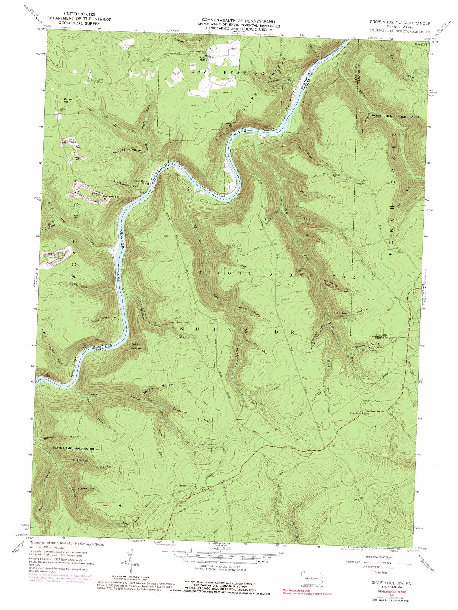
USGS Topo Quad 41077b8 - 1:24,000 scale
| Topo Map Name: | Snow Shoe Nw |
| USGS Topo Quad ID: | 41077b8 |
| Print Size: | ca. 21 1/4" wide x 27" high |
| Southeast Coordinates: | 41.125° N latitude / 77.875° W longitude |
| Map Center Coordinates: | 41.1875° N latitude / 77.9375° W longitude |
| U.S. State: | PA |
| Filename: | o41077b8.jpg |
| Download Map JPG Image: | Snow Shoe Nw topo map 1:24,000 scale |
| Map Type: | Topographic |
| Topo Series: | 7.5´ |
| Map Scale: | 1:24,000 |
| Source of Map Images: | United States Geological Survey (USGS) |
| Alternate Map Versions: |
Snow Shoe NW PA 1960, updated 1962 Download PDF Buy paper map Snow Shoe NW PA 1960, updated 1970 Download PDF Buy paper map Snow Shoe NW PA 1960, updated 1972 Download PDF Buy paper map Snow Shoe NW PA 1960, updated 1983 Download PDF Buy paper map Snow Shoe NW PA 1960, updated 1992 Download PDF Buy paper map Snow Shoe NW PA 2010 Download PDF Buy paper map Snow Shoe NW PA 2013 Download PDF Buy paper map Snow Shoe NW PA 2016 Download PDF Buy paper map |
1:24,000 Topo Quads surrounding Snow Shoe Nw
Cameron |
First Fork |
Hammersley Fork |
Tamarack |
Young Womans Creek |
Driftwood |
Sinnemahoning |
Keating |
Renovo West |
Renovo East |
Devils Elbow |
Pottersdale |
Snow Shoe Nw |
Snow Shoe Ne |
Howard Nw |
Frenchville |
Karthaus |
Snow Shoe |
Snow Shoe Se |
Howard |
Philipsburg |
Black Moshannon |
Bear Knob |
Bellefonte |
Mingoville |
> Back to 41077a1 at 1:100,000 scale
> Back to 41076a1 at 1:250,000 scale
> Back to U.S. Topo Maps home
Snow Shoe Nw topo map: Gazetteer
Snow Shoe Nw: Pillars
Panther Fire Tower elevation 683m 2240′Snow Shoe Nw: Populated Places
Birch elevation 231m 757′Twin Hollows elevation 392m 1286′
Snow Shoe Nw: Streams
Birch Island Run elevation 225m 738′Black Stump Run elevation 228m 748′
Bog Ore Run elevation 460m 1509′
Bougher Run elevation 228m 748′
Burns Run elevation 214m 702′
Burnt Shanty Run elevation 420m 1377′
Dry Run elevation 208m 682′
Fields Run elevation 224m 734′
First Fork elevation 265m 869′
Gaines Run elevation 296m 971′
Grove Run elevation 219m 718′
Horse Fork elevation 328m 1076′
Kyler Fork elevation 511m 1676′
Leaning Pine Run elevation 221m 725′
Little Birch Island Run elevation 265m 869′
Little Bougher Run elevation 230m 754′
Moores Run elevation 219m 718′
Morris Run elevation 215m 705′
Owl Run elevation 351m 1151′
Second Fork elevation 322m 1056′
Shade Fork elevation 278m 912′
South Fork Bougher Run elevation 259m 849′
Spruce Run elevation 233m 764′
Sugarcamp Run elevation 224m 734′
West Branch Spruce Run elevation 274m 898′
Snow Shoe Nw: Summits
Bear Hill elevation 590m 1935′Grove Hill elevation 472m 1548′
McCormack Hill elevation 507m 1663′
Snow Shoe Nw: Trails
Bloom Draft Trail elevation 646m 2119′Bougher Run Trail elevation 533m 1748′
Eddy Lick Trail elevation 663m 2175′
Fields Run Trail elevation 307m 1007′
Frenchman Trail elevation 538m 1765′
Grove Run Trail elevation 354m 1161′
Har Brac Trail elevation 645m 2116′
J U Hollow Trail elevation 614m 2014′
Jews Run Jeep Trail elevation 356m 1167′
Ju Hollow Trail elevation 613m 2011′
Kellys Field Trail elevation 415m 1361′
Kyler Trail elevation 651m 2135′
Log Hollow Trail elevation 640m 2099′
Lonely Trail elevation 555m 1820′
Morris Run Trail elevation 350m 1148′
Packer Trail elevation 564m 1850′
Panther Run Trail elevation 633m 2076′
Perry Trail elevation 456m 1496′
Plantation Trail elevation 652m 2139′
Spruce Run Trail elevation 329m 1079′
Wolf Branch Trail elevation 646m 2119′
Yost Run Trail elevation 360m 1181′
Snow Shoe Nw: Valleys
Bloom Draft elevation 534m 1751′Buckshot Hollow elevation 437m 1433′
Delaney Hollow elevation 253m 830′
Fisher Hollow elevation 374m 1227′
Frenchman Hollow elevation 464m 1522′
Holt Hollow elevation 481m 1578′
Log Hollow elevation 271m 889′
Log Hollow elevation 386m 1266′
Panther Hollow elevation 460m 1509′
Tanglefoot Hollow elevation 286m 938′
Wildcat Hollow elevation 239m 784′
Wrigley Hollow elevation 370m 1213′
Snow Shoe Nw digital topo map on disk
Buy this Snow Shoe Nw topo map showing relief, roads, GPS coordinates and other geographical features, as a high-resolution digital map file on DVD:
New York, Vermont, Connecticut & Western Massachusetts
Buy digital topo maps: New York, Vermont, Connecticut & Western Massachusetts