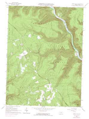
Jersey Mills Topo Map Pennsylvania
To zoom in, hover over the map of Jersey Mills
USGS Topo Quad 41077c4 - 1:24,000 scale
| Topo Map Name: | Jersey Mills |
| USGS Topo Quad ID: | 41077c4 |
| Print Size: | ca. 21 1/4" wide x 27" high |
| Southeast Coordinates: | 41.25° N latitude / 77.375° W longitude |
| Map Center Coordinates: | 41.3125° N latitude / 77.4375° W longitude |
| U.S. State: | PA |
| Filename: | o41077c4.jpg |
| Download Map JPG Image: | Jersey Mills topo map 1:24,000 scale |
| Map Type: | Topographic |
| Topo Series: | 7.5´ |
| Map Scale: | 1:24,000 |
| Source of Map Images: | United States Geological Survey (USGS) |
| Alternate Map Versions: |
Jersey Mills PA 1965, updated 1967 Download PDF Buy paper map Jersey Mills PA 1965, updated 1974 Download PDF Buy paper map Jersey Mills PA 1965, updated 1990 Download PDF Buy paper map Jersey Mills PA 2010 Download PDF Buy paper map Jersey Mills PA 2013 Download PDF Buy paper map Jersey Mills PA 2016 Download PDF Buy paper map |
1:24,000 Topo Quads surrounding Jersey Mills
> Back to 41077a1 at 1:100,000 scale
> Back to 41076a1 at 1:250,000 scale
> Back to U.S. Topo Maps home
Jersey Mills topo map: Gazetteer
Jersey Mills: Areas
Miller Run Natural Area elevation 569m 1866′Jersey Mills: Parks
Upper Pine Bottom State Park elevation 286m 938′Jersey Mills: Populated Places
Gallagher elevation 490m 1607′Haneyville elevation 526m 1725′
Jersey Mills elevation 198m 649′
Jersey Mills: Streams
Browns Run elevation 195m 639′Callahan Run elevation 197m 646′
Dry Run elevation 189m 620′
English Run elevation 247m 810′
First Branch Ott Fork elevation 319m 1046′
Lower Pine Bottom Run elevation 183m 600′
McClure Run elevation 195m 639′
Ott Fork elevation 265m 869′
Second Branch Ott Creek elevation 385m 1263′
Shanty Run elevation 195m 639′
Upper Pine Bottom Run elevation 183m 600′
Veley Fork elevation 364m 1194′
Zinck Fork elevation 389m 1276′
Jersey Mills: Summits
Huntley Mountain elevation 556m 1824′Jersey Mills: Trails
Big Fork Trail elevation 532m 1745′Browns Run Trail elevation 487m 1597′
Dry Run Trail elevation 303m 994′
Fred Hollow Trail elevation 525m 1722′
Gamble Trail elevation 400m 1312′
Green Trail elevation 630m 2066′
Hogback Trail elevation 543m 1781′
Martin Trail elevation 425m 1394′
McClure Run Trail elevation 374m 1227′
McClure Trail elevation 571m 1873′
Middle Hill Trail elevation 425m 1394′
Shanty Point Trail elevation 557m 1827′
Shutman Path elevation 561m 1840′
Torbert Trail elevation 573m 1879′
Twin Pines Trail elevation 554m 1817′
Wentzel Trail elevation 528m 1732′
Wolf Path elevation 422m 1384′
Jersey Mills: Valleys
Gorman Draft elevation 367m 1204′Pine Hollow elevation 310m 1017′
Jersey Mills digital topo map on disk
Buy this Jersey Mills topo map showing relief, roads, GPS coordinates and other geographical features, as a high-resolution digital map file on DVD:
New York, Vermont, Connecticut & Western Massachusetts
Buy digital topo maps: New York, Vermont, Connecticut & Western Massachusetts


