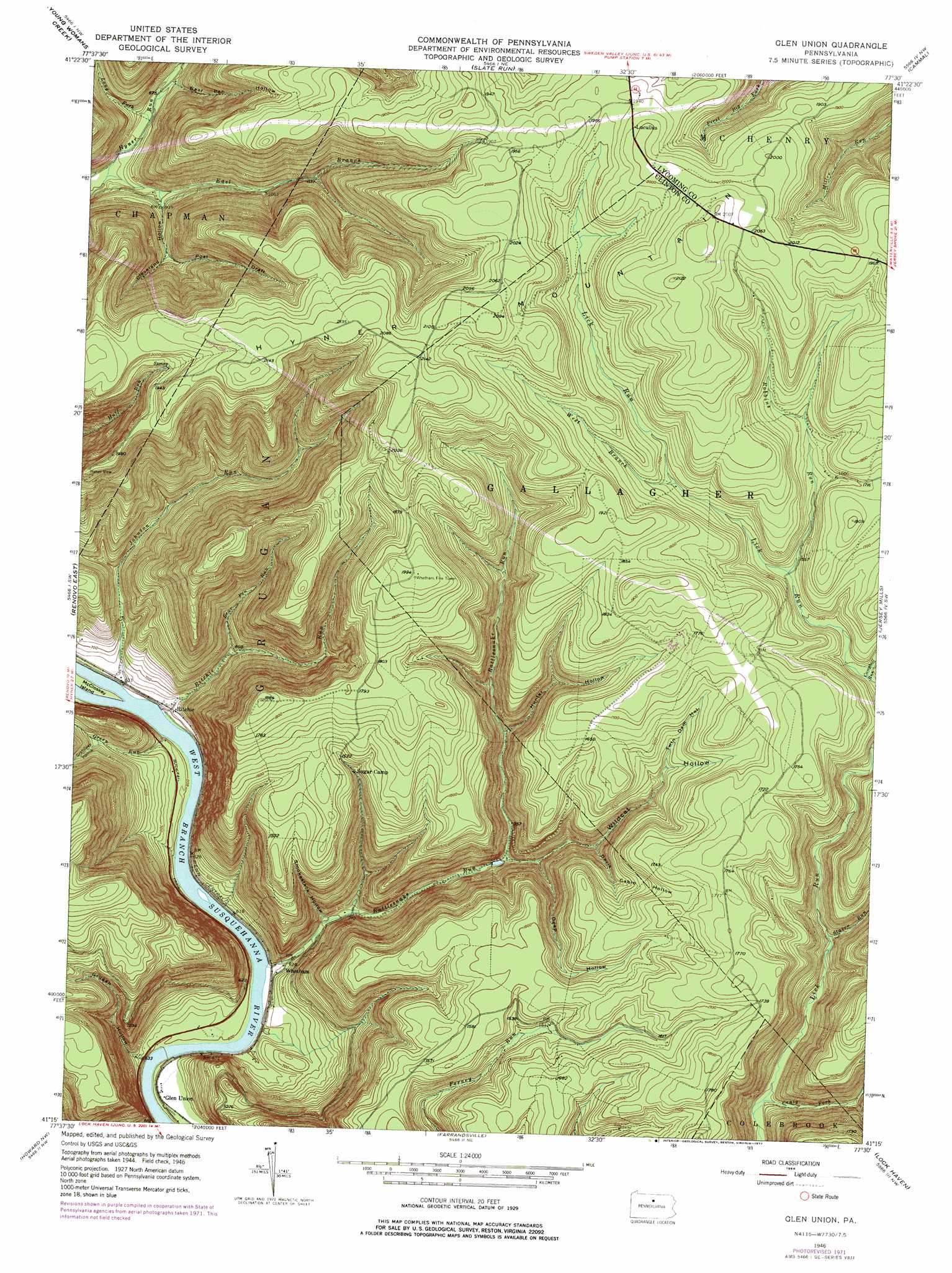
Glen Union Topo Map Pennsylvania
To zoom in, hover over the map of Glen Union
USGS Topo Quad 41077c5 - 1:24,000 scale
| Topo Map Name: | Glen Union |
| USGS Topo Quad ID: | 41077c5 |
| Print Size: | ca. 21 1/4" wide x 27" high |
| Southeast Coordinates: | 41.25° N latitude / 77.5° W longitude |
| Map Center Coordinates: | 41.3125° N latitude / 77.5625° W longitude |
| U.S. State: | PA |
| Filename: | o41077c5.jpg |
| Download Map JPG Image: | Glen Union topo map 1:24,000 scale |
| Map Type: | Topographic |
| Topo Series: | 7.5´ |
| Map Scale: | 1:24,000 |
| Source of Map Images: | United States Geological Survey (USGS) |
| Alternate Map Versions: |
Glen Union PA 1946, updated 1964 Download PDF Buy paper map Glen Union PA 1946, updated 1968 Download PDF Buy paper map Glen Union PA 1946, updated 1972 Download PDF Buy paper map Glen Union PA 1946, updated 1977 Download PDF Buy paper map Glen Union PA 1946, updated 1977 Download PDF Buy paper map Glen Union PA 1948 Download PDF Buy paper map Glen Union PA 1948, updated 1948 Download PDF Buy paper map Glen Union PA 2010 Download PDF Buy paper map Glen Union PA 2013 Download PDF Buy paper map Glen Union PA 2016 Download PDF Buy paper map |
1:24,000 Topo Quads surrounding Glen Union
Short Run |
Oleona |
Lee Fire Tower |
Cedar Run |
Morris |
Tamarack |
Young Womans Creek |
Slate Run |
Cammal |
English Center |
Renovo West |
Renovo East |
Glen Union |
Jersey Mills |
Waterville |
Snow Shoe Ne |
Howard Nw |
Farrandsville |
Lock Haven |
Jersey Shore |
Snow Shoe Se |
Howard |
Beech Creek |
Mill Hall |
Loganton |
> Back to 41077a1 at 1:100,000 scale
> Back to 41076a1 at 1:250,000 scale
> Back to U.S. Topo Maps home
Glen Union topo map: Gazetteer
Glen Union: Airports
Ponderosa Airport elevation 544m 1784′Glen Union: Parks
Hyner View State Park elevation 589m 1932′Glen Union: Populated Places
Glen Union elevation 182m 597′Hyner View elevation 589m 1932′
Lucullus elevation 604m 1981′
Ritchie elevation 191m 626′
Whetham elevation 189m 620′
Glen Union: Streams
Bear Pen Run elevation 234m 767′Campbell Run elevation 440m 1443′
Craig Fork elevation 321m 1053′
East Branch Hyner Run elevation 246m 807′
Green Run elevation 183m 600′
Johnson Run elevation 177m 580′
Long Fork elevation 262m 859′
Mill Run elevation 171m 561′
Rattlesnake Run elevation 178m 583′
Ritchie Run elevation 177m 580′
Robbins Run elevation 464m 1522′
Staver Run elevation 356m 1167′
West Branch Lick Run elevation 503m 1650′
Glen Union: Summits
Hyner Mountain elevation 639m 2096′Glen Union: Trails
Bear Pen Hollow Trail elevation 550m 1804′Boyer Trail elevation 508m 1666′
Cryder Trail elevation 479m 1571′
First Branch Trail elevation 556m 1824′
Flat Ridge Trail elevation 518m 1699′
Hyner View Trail elevation 514m 1686′
Johnson Ferney Trail elevation 388m 1272′
Lick Run Trail elevation 515m 1689′
Oak Ridge Trail elevation 512m 1679′
Park Line Trail elevation 502m 1646′
Poff Trail elevation 519m 1702′
Robins Ridge Trail elevation 517m 1696′
Sinking Spring Trail elevation 526m 1725′
West Branch Lick Run Trail elevation 560m 1837′
Whetham Tower Trail elevation 567m 1860′
Glen Union: Valleys
Bear Pen Hollow elevation 264m 866′Cleveland Hollow elevation 272m 892′
Davis Cabin Hollow elevation 338m 1108′
Deep Hollow elevation 294m 964′
Goodman Hollow elevation 282m 925′
Grandpap Hollow elevation 246m 807′
Grugan Hollow elevation 171m 561′
Hunter Hollow elevation 334m 1095′
Post Draft elevation 316m 1036′
Smokestack Hollow elevation 210m 688′
Twin Dam Hollow elevation 436m 1430′
Wildcat Hollow elevation 283m 928′
Glen Union digital topo map on disk
Buy this Glen Union topo map showing relief, roads, GPS coordinates and other geographical features, as a high-resolution digital map file on DVD:
New York, Vermont, Connecticut & Western Massachusetts
Buy digital topo maps: New York, Vermont, Connecticut & Western Massachusetts