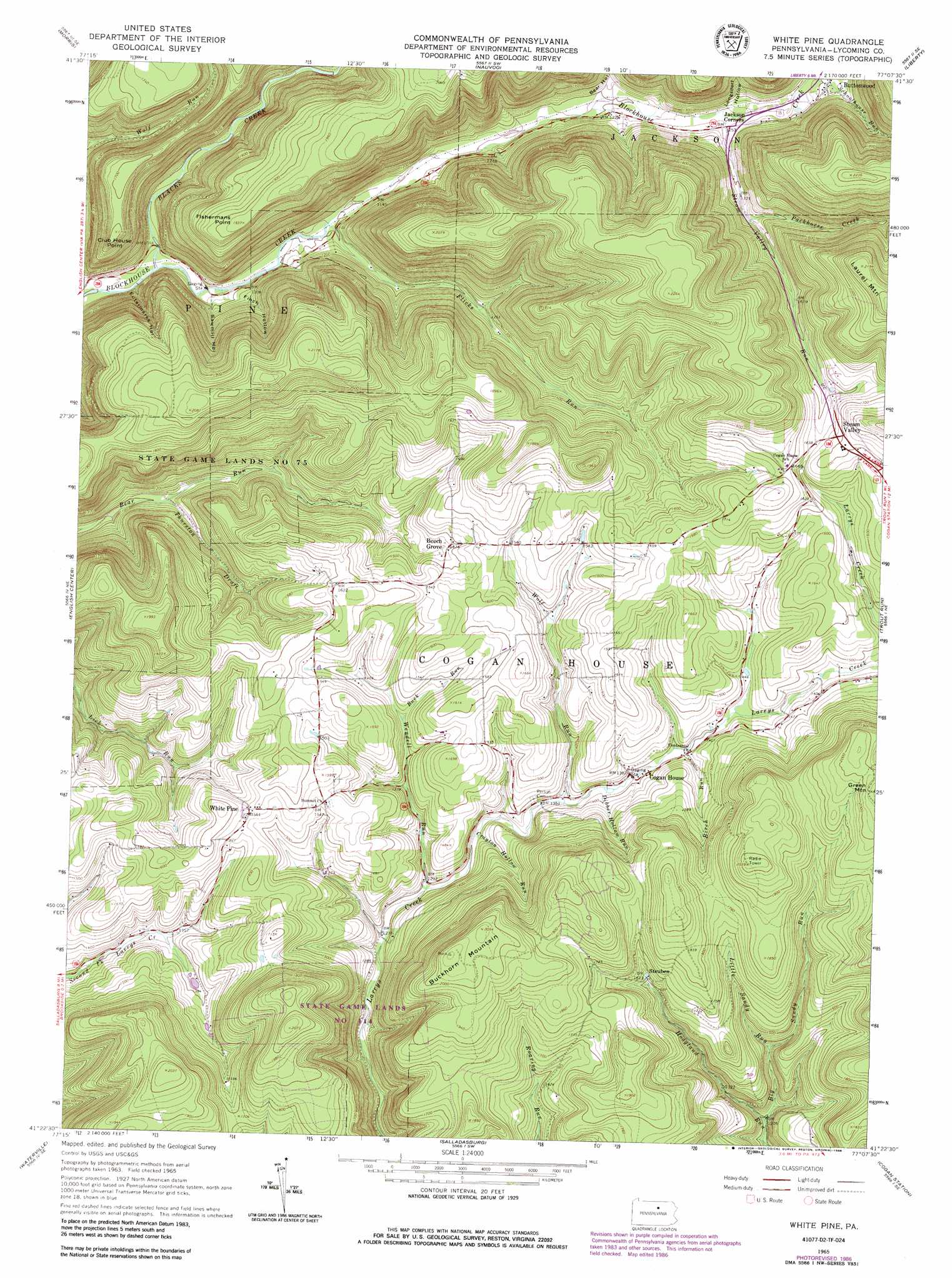
White Pine Topo Map Pennsylvania
To zoom in, hover over the map of White Pine
USGS Topo Quad 41077d2 - 1:24,000 scale
| Topo Map Name: | White Pine |
| USGS Topo Quad ID: | 41077d2 |
| Print Size: | ca. 21 1/4" wide x 27" high |
| Southeast Coordinates: | 41.375° N latitude / 77.125° W longitude |
| Map Center Coordinates: | 41.4375° N latitude / 77.1875° W longitude |
| U.S. State: | PA |
| Filename: | o41077d2.jpg |
| Download Map JPG Image: | White Pine topo map 1:24,000 scale |
| Map Type: | Topographic |
| Topo Series: | 7.5´ |
| Map Scale: | 1:24,000 |
| Source of Map Images: | United States Geological Survey (USGS) |
| Alternate Map Versions: |
White Pine PA 1965, updated 1967 Download PDF Buy paper map White Pine PA 1965, updated 1973 Download PDF Buy paper map White Pine PA 1965, updated 1986 Download PDF Buy paper map White Pine PA 2010 Download PDF Buy paper map White Pine PA 2013 Download PDF Buy paper map White Pine PA 2016 Download PDF Buy paper map |
1:24,000 Topo Quads surrounding White Pine
Tiadaghton |
Antrim |
Cherry Flats |
Blossburg |
Gleason |
Cedar Run |
Morris |
Nauvoo |
Liberty |
Ralston |
Cammal |
English Center |
White Pine |
Trout Run |
Bodines |
Jersey Mills |
Waterville |
Salladasburg |
Cogan Station |
Montoursville North |
Lock Haven |
Jersey Shore |
Linden |
Williamsport |
Montoursville South |
> Back to 41077a1 at 1:100,000 scale
> Back to 41076a1 at 1:250,000 scale
> Back to U.S. Topo Maps home
White Pine topo map: Gazetteer
White Pine: Populated Places
Beech Grove elevation 451m 1479′Buttonwood elevation 401m 1315′
Steam Valley elevation 518m 1699′
Steuben elevation 495m 1624′
White Pine elevation 477m 1564′
White Pine: Streams
Big Sandy Run elevation 363m 1190′Birch Run elevation 425m 1394′
Blacks Creek elevation 313m 1026′
Buck Run elevation 430m 1410′
Crayton Hollow Run elevation 403m 1322′
Dibber Hollow Run elevation 414m 1358′
Flicks Run elevation 331m 1085′
Little Sandy Run elevation 406m 1332′
Packhorse Creek elevation 414m 1358′
Steam Valley Run elevation 376m 1233′
Wendell Run elevation 391m 1282′
Wolf Run elevation 412m 1351′
White Pine: Summits
Buckhorn Mountain elevation 636m 2086′Club House Point elevation 524m 1719′
Fishermans Point elevation 595m 1952′
White Pine: Valleys
Bear Hollow elevation 362m 1187′Eutermarks Hollow elevation 331m 1085′
Finch Hollow elevation 329m 1079′
Longsdorf Hollow elevation 391m 1282′
Sawmill Hollow elevation 335m 1099′
Thurston Draft elevation 340m 1115′
White Pine digital topo map on disk
Buy this White Pine topo map showing relief, roads, GPS coordinates and other geographical features, as a high-resolution digital map file on DVD:
New York, Vermont, Connecticut & Western Massachusetts
Buy digital topo maps: New York, Vermont, Connecticut & Western Massachusetts