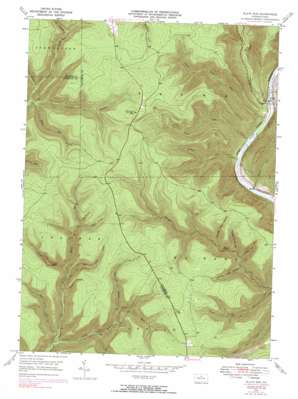
Slate Run Topo Map Pennsylvania
To zoom in, hover over the map of Slate Run
USGS Topo Quad 41077d5 - 1:24,000 scale
| Topo Map Name: | Slate Run |
| USGS Topo Quad ID: | 41077d5 |
| Print Size: | ca. 21 1/4" wide x 27" high |
| Southeast Coordinates: | 41.375° N latitude / 77.5° W longitude |
| Map Center Coordinates: | 41.4375° N latitude / 77.5625° W longitude |
| U.S. State: | PA |
| Filename: | o41077d5.jpg |
| Download Map JPG Image: | Slate Run topo map 1:24,000 scale |
| Map Type: | Topographic |
| Topo Series: | 7.5´ |
| Map Scale: | 1:24,000 |
| Source of Map Images: | United States Geological Survey (USGS) |
| Alternate Map Versions: |
Slate Run PA 1946, updated 1958 Download PDF Buy paper map Slate Run PA 1946, updated 1969 Download PDF Buy paper map Slate Run PA 1946, updated 1972 Download PDF Buy paper map Slate Run PA 1946, updated 1990 Download PDF Buy paper map Slate Run PA 1948 Download PDF Buy paper map Slate Run PA 1948 Download PDF Buy paper map Slate Run PA 1994, updated 1999 Download PDF Buy paper map Slate Run PA 2010 Download PDF Buy paper map Slate Run PA 2013 Download PDF Buy paper map Slate Run PA 2016 Download PDF Buy paper map |
1:24,000 Topo Quads surrounding Slate Run
> Back to 41077a1 at 1:100,000 scale
> Back to 41076a1 at 1:250,000 scale
> Back to U.S. Topo Maps home
Slate Run topo map: Gazetteer
Slate Run: Populated Places
Slate Run elevation 230m 754′Slate Run: Streams
Abes Run elevation 292m 958′Baldwin Branch elevation 370m 1213′
Benson Run elevation 377m 1236′
Bonnell Run elevation 219m 718′
Callahan Run elevation 216m 708′
Cougar Run elevation 369m 1210′
County Line Branch elevation 370m 1213′
Dyer Branch elevation 469m 1538′
Left Branch Hyner Run elevation 300m 984′
Little Slate Run elevation 219m 718′
Naval Run elevation 219m 718′
Riffle Run elevation 217m 711′
Right Branch Hyner Run elevation 283m 928′
Second Big Fork elevation 271m 889′
Slate Run elevation 223m 731′
Spring Run elevation 379m 1243′
Wilcox Branch elevation 386m 1266′
Slate Run: Trails
Baldwin Point Trail elevation 629m 2063′Bear Trap Trail elevation 483m 1584′
Benson Trail elevation 577m 1893′
Big Boyer Trail elevation 522m 1712′
Blackberry Trail elevation 605m 1984′
Callahan Trail elevation 314m 1030′
Campbell Trail elevation 437m 1433′
Dugan Trail elevation 601m 1971′
Gas Line Trail elevation 640m 2099′
Golden Eagle Trail elevation 281m 921′
Harrowed Trail elevation 628m 2060′
Highwood Trail elevation 559m 1833′
Little Boyer Trail elevation 490m 1607′
Little Slate Run Trail elevation 581m 1906′
McClure Ridge Trail elevation 551m 1807′
Mill Hollow Trail elevation 581m 1906′
Reeder Trail elevation 495m 1624′
Refuge Trail elevation 626m 2053′
Riffle Trail elevation 403m 1322′
Rock Run Trail elevation 578m 1896′
Shay Trail elevation 591m 1938′
Slide Hollow Trail elevation 537m 1761′
Slide Hollow Trail elevation 440m 1443′
Store Quarry Trail elevation 572m 1876′
Three Ridge Trail elevation 590m 1935′
Weaver Trail elevation 427m 1400′
Slate Run: Valleys
Big Slide Hollow elevation 360m 1181′Cannon Hole Hollow elevation 310m 1017′
Holt Hollow elevation 454m 1489′
Muschino Hollow elevation 342m 1122′
Number Four Hollow elevation 361m 1184′
Number Three Hollow elevation 333m 1092′
Number Two Hollow elevation 329m 1079′
Slide Hollow elevation 446m 1463′
Slate Run digital topo map on disk
Buy this Slate Run topo map showing relief, roads, GPS coordinates and other geographical features, as a high-resolution digital map file on DVD:
New York, Vermont, Connecticut & Western Massachusetts
Buy digital topo maps: New York, Vermont, Connecticut & Western Massachusetts


