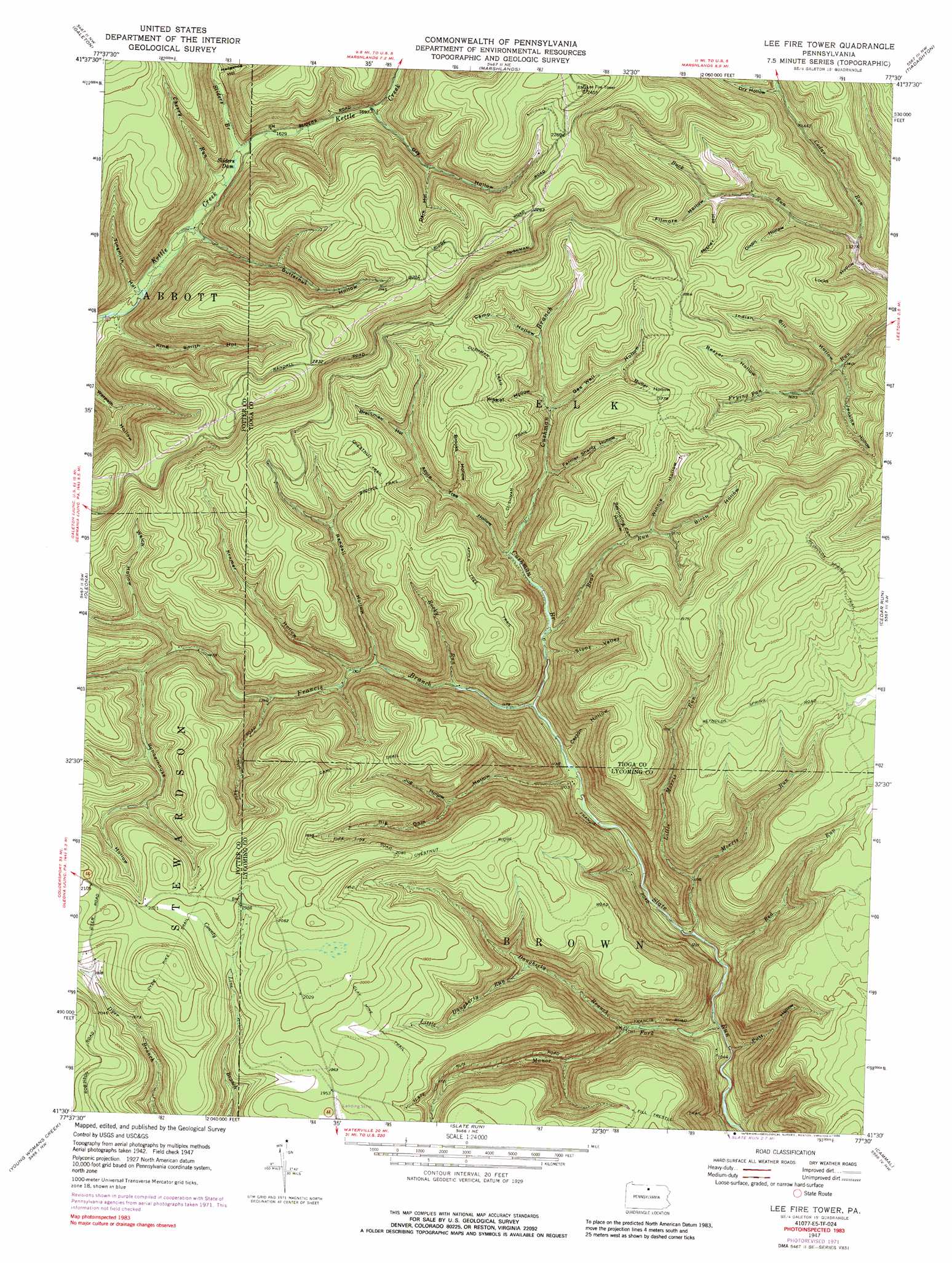
Lee Fire Tower Topo Map Pennsylvania
To zoom in, hover over the map of Lee Fire Tower
USGS Topo Quad 41077e5 - 1:24,000 scale
| Topo Map Name: | Lee Fire Tower |
| USGS Topo Quad ID: | 41077e5 |
| Print Size: | ca. 21 1/4" wide x 27" high |
| Southeast Coordinates: | 41.5° N latitude / 77.5° W longitude |
| Map Center Coordinates: | 41.5625° N latitude / 77.5625° W longitude |
| U.S. State: | PA |
| Filename: | o41077e5.jpg |
| Download Map JPG Image: | Lee Fire Tower topo map 1:24,000 scale |
| Map Type: | Topographic |
| Topo Series: | 7.5´ |
| Map Scale: | 1:24,000 |
| Source of Map Images: | United States Geological Survey (USGS) |
| Alternate Map Versions: |
Lee Fire Tower PA 1947, updated 1954 Download PDF Buy paper map Lee Fire Tower PA 1947, updated 1972 Download PDF Buy paper map Lee Fire Tower PA 1947, updated 1977 Download PDF Buy paper map Lee Fire Tower PA 1947, updated 1988 Download PDF Buy paper map Lee Fire Tower PA 1947, updated 1988 Download PDF Buy paper map Lee Fire Tower PA 1950 Download PDF Buy paper map Lee Fire Tower PA 1977, updated 1979 Download PDF Buy paper map Lee Fire Tower PA 1994, updated 1999 Download PDF Buy paper map Lee Fire Tower PA 2010 Download PDF Buy paper map Lee Fire Tower PA 2013 Download PDF Buy paper map Lee Fire Tower PA 2016 Download PDF Buy paper map |
1:24,000 Topo Quads surrounding Lee Fire Tower
Brookland |
West Pike |
Sabinsville |
Asaph |
Keeneyville |
Cherry Springs |
Galeton |
Marshlands |
Tiadaghton |
Antrim |
Short Run |
Oleona |
Lee Fire Tower |
Cedar Run |
Morris |
Tamarack |
Young Womans Creek |
Slate Run |
Cammal |
English Center |
Renovo West |
Renovo East |
Glen Union |
Jersey Mills |
Waterville |
> Back to 41077e1 at 1:100,000 scale
> Back to 41076a1 at 1:250,000 scale
> Back to U.S. Topo Maps home
Lee Fire Tower topo map: Gazetteer
Lee Fire Tower: Airports
Black Forest Inn Airport elevation 601m 1971′Lee Fire Tower: Areas
Algerine Wild Area elevation 577m 1893′Lee Fire Tower: Dams
Sliders Dam elevation 485m 1591′Lee Fire Tower: Streams
Bear Run elevation 382m 1253′Buck Run elevation 399m 1309′
Cherry Run elevation 483m 1584′
Cushman Branch elevation 421m 1381′
Daugherty Branch elevation 322m 1056′
Francis Branch elevation 352m 1154′
Little Daugherty Run elevation 405m 1328′
Little Morris Run elevation 340m 1115′
Manor Fork elevation 276m 905′
Morris Run elevation 300m 984′
Red Run elevation 290m 951′
Rocky Run elevation 371m 1217′
Sliders Branch elevation 492m 1614′
Lee Fire Tower: Trails
Apple Tree Trail elevation 549m 1801′Big Dam Hollow Trail elevation 514m 1686′
Brooks Trail elevation 551m 1807′
Camp Trail elevation 606m 1988′
Carson Hollow Trail elevation 576m 1889′
Chestnut Trail elevation 562m 1843′
Clay Mine Trail elevation 615m 2017′
Cushman Trail elevation 523m 1715′
Dyer Pike Trail elevation 660m 2165′
Farmer Shanty Trail elevation 505m 1656′
Fill Trestle Trail elevation 555m 1820′
Gaswell Trail elevation 462m 1515′
Kramer Trail elevation 461m 1512′
Little Morris Trail elevation 592m 1942′
Morris Trail elevation 612m 2007′
Reynolds Spring Trail elevation 641m 2103′
Rocky Run Trail elevation 460m 1509′
Water Trough Trail elevation 507m 1663′
Lee Fire Tower: Valleys
Apple Tree Hollow elevation 411m 1348′Beaver Hollow elevation 467m 1532′
Big Dam Hollow elevation 350m 1148′
Birch Hollow elevation 471m 1545′
Brackman Hollow elevation 478m 1568′
Brooks Hollow elevation 442m 1450′
Butler Hollow elevation 503m 1650′
Butternut Hollow elevation 479m 1571′
Camp Hollow elevation 488m 1601′
Carson Hollow elevation 362m 1187′
Dark Hollow elevation 562m 1843′
Dixon Hollow elevation 433m 1420′
Dry Hollow elevation 455m 1492′
Dry Hollow elevation 518m 1699′
Farmer Shanty Hollow elevation 445m 1459′
Filmore Hollow elevation 467m 1532′
Gas Well Hollow elevation 457m 1499′
Hedgehog Hollow elevation 520m 1706′
Indian Bill Hollow elevation 428m 1404′
Jenkins Hollow elevation 419m 1374′
Jug Hollow elevation 441m 1446′
King Smith Hollow elevation 464m 1522′
Kramer Hollow elevation 402m 1318′
Locks Hollow elevation 406m 1332′
Misner Hollow elevation 460m 1509′
Putt Hollow elevation 274m 898′
Randall Hollow elevation 391m 1282′
Schoolhouse Hollow elevation 467m 1532′
Sprinkling Canal Hollow elevation 455m 1492′
Stony Valley elevation 375m 1230′
Tinsmith Hollow elevation 470m 1541′
Welch Hollow elevation 473m 1551′
Wildcat Hollow elevation 470m 1541′
Winnie Hollow elevation 467m 1532′
Lee Fire Tower digital topo map on disk
Buy this Lee Fire Tower topo map showing relief, roads, GPS coordinates and other geographical features, as a high-resolution digital map file on DVD:
New York, Vermont, Connecticut & Western Massachusetts
Buy digital topo maps: New York, Vermont, Connecticut & Western Massachusetts