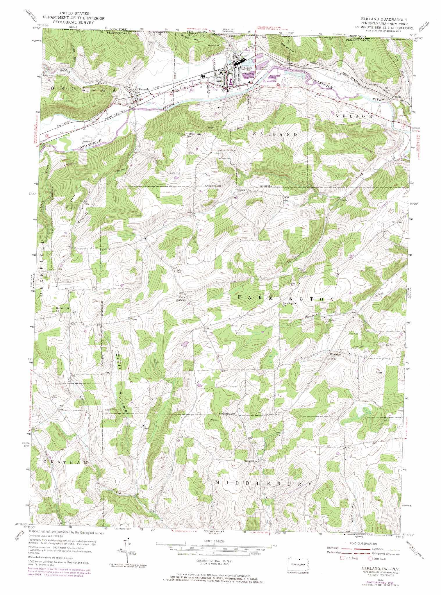
Elkland Topo Map Pennsylvania
To zoom in, hover over the map of Elkland
USGS Topo Quad 41077h3 - 1:24,000 scale
| Topo Map Name: | Elkland |
| USGS Topo Quad ID: | 41077h3 |
| Print Size: | ca. 21 1/4" wide x 27" high |
| Southeast Coordinates: | 41.875° N latitude / 77.25° W longitude |
| Map Center Coordinates: | 41.9375° N latitude / 77.3125° W longitude |
| U.S. States: | PA, NY |
| Filename: | o41077h3.jpg |
| Download Map JPG Image: | Elkland topo map 1:24,000 scale |
| Map Type: | Topographic |
| Topo Series: | 7.5´ |
| Map Scale: | 1:24,000 |
| Source of Map Images: | United States Geological Survey (USGS) |
| Alternate Map Versions: |
Elkland PA 1954, updated 1956 Download PDF Buy paper map Elkland PA 1954, updated 1968 Download PDF Buy paper map Elkland PA 1954, updated 1971 Download PDF Buy paper map Elkland PA 1954, updated 1971 Download PDF Buy paper map Elkland PA 1999, updated 2001 Download PDF Buy paper map Elkland PA 2010 Download PDF Buy paper map Elkland PA 2013 Download PDF Buy paper map Elkland PA 2016 Download PDF Buy paper map |
1:24,000 Topo Quads surrounding Elkland
South Canisteo |
Cameron |
Rathbone |
Campbell |
Corning |
Troupsburg |
Woodhull |
Borden |
Addison |
Caton |
Potter Brook |
Knoxville |
Elkland |
Tioga |
Jackson Summit |
Sabinsville |
Asaph |
Keeneyville |
Crooked Creek |
Mansfield |
Marshlands |
Tiadaghton |
Antrim |
Cherry Flats |
Blossburg |
> Back to 41077e1 at 1:100,000 scale
> Back to 41076a1 at 1:250,000 scale
> Back to U.S. Topo Maps home
Elkland topo map: Gazetteer
Elkland: Airports
Baker Airport elevation 488m 1601′Elkland: Populated Places
Elbridge elevation 501m 1643′Elkland elevation 344m 1128′
Odle Corners elevation 491m 1610′
Osceola elevation 353m 1158′
Shinglebury elevation 458m 1502′
Elkland: Post Offices
Elkland Post Office elevation 345m 1131′Osceola Post Office elevation 354m 1161′
Elkland: Streams
Bulkley Creek elevation 357m 1171′Camp Brook elevation 350m 1148′
Camp Brook elevation 341m 1118′
Gulf Run elevation 384m 1259′
Holden Creek elevation 351m 1151′
Holden Creek elevation 351m 1151′
Redhouse Run elevation 390m 1279′
Thornbottom Creek elevation 331m 1085′
Windfall Brook elevation 353m 1158′
Elkland: Summits
Barney Hill elevation 499m 1637′Briar Hill elevation 551m 1807′
Mutton Hill elevation 476m 1561′
Windfall Hill elevation 559m 1833′
Elkland: Valleys
Croft Hollow elevation 450m 1476′Elkland digital topo map on disk
Buy this Elkland topo map showing relief, roads, GPS coordinates and other geographical features, as a high-resolution digital map file on DVD:
New York, Vermont, Connecticut & Western Massachusetts
Buy digital topo maps: New York, Vermont, Connecticut & Western Massachusetts