Potter Brook Topo Map Pennsylvania
To zoom in, hover over the map of Potter Brook
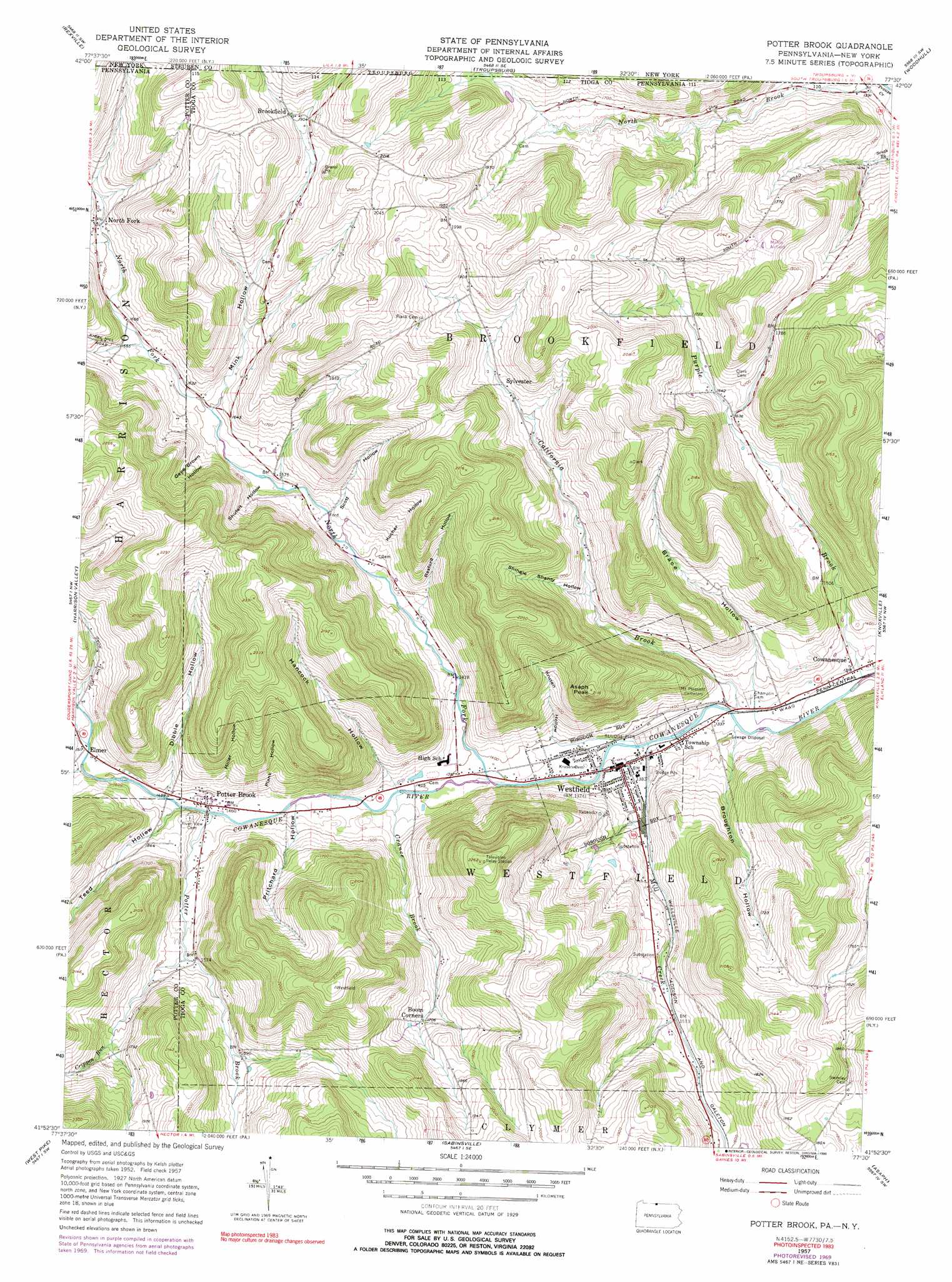
USGS Topo Quad 41077h5 - 1:24,000 scale
| Topo Map Name: | Potter Brook |
| USGS Topo Quad ID: | 41077h5 |
| Print Size: | ca. 21 1/4" wide x 27" high |
| Southeast Coordinates: | 41.875° N latitude / 77.5° W longitude |
| Map Center Coordinates: | 41.9375° N latitude / 77.5625° W longitude |
| U.S. States: | PA, NY |
| Filename: | o41077h5.jpg |
| Download Map JPG Image: | Potter Brook topo map 1:24,000 scale |
| Map Type: | Topographic |
| Topo Series: | 7.5´ |
| Map Scale: | 1:24,000 |
| Source of Map Images: | United States Geological Survey (USGS) |
| Alternate Map Versions: |
Potter Brook PA 1957, updated 1958 Download PDF Buy paper map Potter Brook PA 1957, updated 1971 Download PDF Buy paper map Potter Brook PA 1957, updated 1976 Download PDF Buy paper map Potter Brook PA 1957, updated 1990 Download PDF Buy paper map Potter Brook PA 1957, updated 1990 Download PDF Buy paper map Potter Brook PA 1957, updated 1999 Download PDF Buy paper map Potter Brook PA 2010 Download PDF Buy paper map Potter Brook PA 2013 Download PDF Buy paper map Potter Brook PA 2016 Download PDF Buy paper map |
1:24,000 Topo Quads surrounding Potter Brook
Andover |
Greenwood |
South Canisteo |
Cameron |
Rathbone |
Whitesville |
Rexville |
Troupsburg |
Woodhull |
Borden |
Ulysses |
Harrison Valley |
Potter Brook |
Knoxville |
Elkland |
Brookland |
West Pike |
Sabinsville |
Asaph |
Keeneyville |
Cherry Springs |
Galeton |
Marshlands |
Tiadaghton |
Antrim |
> Back to 41077e1 at 1:100,000 scale
> Back to 41076a1 at 1:250,000 scale
> Back to U.S. Topo Maps home
Potter Brook topo map: Gazetteer
Potter Brook: Airports
Malco Airport elevation 606m 1988′Potter Brook: Dams
Pa-456 Dam elevation 463m 1519′Potter Brook: Populated Places
Brookfield elevation 583m 1912′Elmer elevation 462m 1515′
North Fork elevation 523m 1715′
Potter Brook elevation 447m 1466′
Purple Brook (historical) elevation 571m 1873′
Sylvester elevation 532m 1745′
Westfield elevation 416m 1364′
Potter Brook: Streams
California Brook elevation 407m 1335′Closes Creek elevation 429m 1407′
Crance Brook elevation 427m 1400′
Crippen Run elevation 475m 1558′
Dodge Hollow Run elevation 462m 1515′
Mill Creek elevation 413m 1354′
Moore Hollow Run elevation 457m 1499′
North Fork Cowanesque River elevation 420m 1377′
Potter Brook elevation 445m 1459′
Purple Brook elevation 398m 1305′
White Branch elevation 527m 1729′
Potter Brook: Summits
Asaph Peak elevation 642m 2106′Potter Brook: Valleys
Brace Hollow elevation 426m 1397′Broughton Hollow elevation 420m 1377′
Dibble Hollow elevation 463m 1519′
Gene Brown Hollow elevation 487m 1597′
Hancock Hollow elevation 456m 1496′
Kocher Hollow elevation 462m 1515′
Krusen Hollow elevation 427m 1400′
Miller Hollow elevation 492m 1614′
Mink Hollow elevation 487m 1597′
Mink Hollow elevation 487m 1597′
Plank Hollow elevation 451m 1479′
Pritchard Hollow elevation 449m 1473′
Rexford Hollow elevation 470m 1541′
Scott Hollow elevation 471m 1545′
Shingle Shanty Hollow elevation 462m 1515′
Shufelt Hollow elevation 475m 1558′
Teed Hollow elevation 457m 1499′
Potter Brook digital topo map on disk
Buy this Potter Brook topo map showing relief, roads, GPS coordinates and other geographical features, as a high-resolution digital map file on DVD:
New York, Vermont, Connecticut & Western Massachusetts
Buy digital topo maps: New York, Vermont, Connecticut & Western Massachusetts