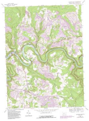
Lecontes Mills Topo Map Pennsylvania
To zoom in, hover over the map of Lecontes Mills
USGS Topo Quad 41078a3 - 1:24,000 scale
| Topo Map Name: | Lecontes Mills |
| USGS Topo Quad ID: | 41078a3 |
| Print Size: | ca. 21 1/4" wide x 27" high |
| Southeast Coordinates: | 41° N latitude / 78.25° W longitude |
| Map Center Coordinates: | 41.0625° N latitude / 78.3125° W longitude |
| U.S. State: | PA |
| Filename: | o41078a3.jpg |
| Download Map JPG Image: | Lecontes Mills topo map 1:24,000 scale |
| Map Type: | Topographic |
| Topo Series: | 7.5´ |
| Map Scale: | 1:24,000 |
| Source of Map Images: | United States Geological Survey (USGS) |
| Alternate Map Versions: |
Lecontes Mills PA 1959, updated 1960 Download PDF Buy paper map Lecontes Mills PA 1959, updated 1960 Download PDF Buy paper map Lecontes Mills PA 1959, updated 1972 Download PDF Buy paper map Lecontes Mills PA 1959, updated 1981 Download PDF Buy paper map Lecontes Mills PA 1959, updated 1983 Download PDF Buy paper map Lecontes Mills PA 1959, updated 1986 Download PDF Buy paper map Lecontes Mills PA 2000, updated 2001 Download PDF Buy paper map Lecontes Mills PA 2010 Download PDF Buy paper map Lecontes Mills PA 2013 Download PDF Buy paper map Lecontes Mills PA 2016 Download PDF Buy paper map |
1:24,000 Topo Quads surrounding Lecontes Mills
> Back to 41078a1 at 1:100,000 scale
> Back to 41078a1 at 1:250,000 scale
> Back to U.S. Topo Maps home
Lecontes Mills topo map: Gazetteer
Lecontes Mills: Airports
Hamilton Heliport elevation 543m 1781′Lecontes Mills: Populated Places
Bald Hill elevation 391m 1282′Bishtown elevation 453m 1486′
Congress Hill elevation 472m 1548′
Croft elevation 338m 1108′
Dale elevation 513m 1683′
Eden elevation 482m 1581′
Egypt elevation 401m 1315′
Gallows Harbor elevation 306m 1003′
Gillingham elevation 503m 1650′
Lecontes Mills elevation 457m 1499′
Needful elevation 434m 1423′
Shawville elevation 334m 1095′
Shiloh elevation 481m 1578′
Surveyor elevation 327m 1072′
Walton elevation 331m 1085′
Lecontes Mills: Streams
Abes Run elevation 322m 1056′Bald Hill Run elevation 308m 1010′
Bear Run elevation 310m 1017′
Bloody Run elevation 320m 1049′
Dale Run elevation 429m 1407′
Little Deer Creek elevation 413m 1354′
Little Surveyor Run elevation 353m 1158′
Little Trout Run elevation 318m 1043′
Millstone Run elevation 315m 1033′
Moravian Run elevation 304m 997′
Stump Lick Run elevation 438m 1437′
Sulphur Run elevation 358m 1174′
Surveyor Run elevation 313m 1026′
Trout Run elevation 316m 1036′
Lecontes Mills digital topo map on disk
Buy this Lecontes Mills topo map showing relief, roads, GPS coordinates and other geographical features, as a high-resolution digital map file on DVD:


