Luthersburg Topo Map Pennsylvania
To zoom in, hover over the map of Luthersburg
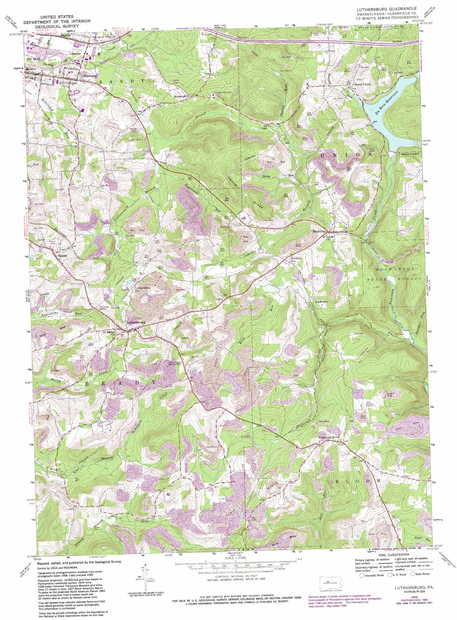
USGS Topo Quad 41078a6 - 1:24,000 scale
| Topo Map Name: | Luthersburg |
| USGS Topo Quad ID: | 41078a6 |
| Print Size: | ca. 21 1/4" wide x 27" high |
| Southeast Coordinates: | 41° N latitude / 78.625° W longitude |
| Map Center Coordinates: | 41.0625° N latitude / 78.6875° W longitude |
| U.S. State: | PA |
| Filename: | o41078a6.jpg |
| Download Map JPG Image: | Luthersburg topo map 1:24,000 scale |
| Map Type: | Topographic |
| Topo Series: | 7.5´ |
| Map Scale: | 1:24,000 |
| Source of Map Images: | United States Geological Survey (USGS) |
| Alternate Map Versions: |
Luthersburg PA 1959, updated 1960 Download PDF Buy paper map Luthersburg PA 1959, updated 1960 Download PDF Buy paper map Luthersburg PA 1959, updated 1972 Download PDF Buy paper map Luthersburg PA 1959, updated 1982 Download PDF Buy paper map Luthersburg PA 1959, updated 1986 Download PDF Buy paper map Luthersburg PA 2010 Download PDF Buy paper map Luthersburg PA 2013 Download PDF Buy paper map Luthersburg PA 2016 Download PDF Buy paper map |
1:24,000 Topo Quads surrounding Luthersburg
Munderf |
Carman |
Brandy Camp |
Kersey |
Weedville |
Hazen |
Falls Creek |
Sabula |
Penfield |
Huntley |
Reynoldsville |
Du Bois |
Luthersburg |
Elliott Park |
Clearfield |
Punxsutawney |
Mcgees Mills |
Mahaffey |
Curwensville |
Glen Richey |
Rochester Mills |
Burnside |
Westover |
Irvona |
Ramey |
> Back to 41078a1 at 1:100,000 scale
> Back to 41078a1 at 1:250,000 scale
> Back to U.S. Topo Maps home
Luthersburg topo map: Gazetteer
Luthersburg: Populated Places
Anderson elevation 529m 1735′Chestnut Grove elevation 598m 1961′
Gelnett elevation 476m 1561′
Home Camp elevation 531m 1742′
Laborde elevation 592m 1942′
Luthersburg elevation 557m 1827′
Oklahoma elevation 440m 1443′
Rockton elevation 536m 1758′
Salem elevation 508m 1666′
Shaffer elevation 433m 1420′
Smith Mills elevation 452m 1482′
Luthersburg: Reservoirs
Du Bois Reservoir elevation 511m 1676′Luthersburg: Ridges
Laurel Ridge elevation 619m 2030′Luthersburg: Streams
Chestnut Run elevation 454m 1489′Dressler Run elevation 511m 1676′
Gravel Lick Run elevation 428m 1404′
Laborde Branch elevation 423m 1387′
Little Anderson Creek elevation 463m 1519′
Luthersburg Branch elevation 436m 1430′
Panther Run elevation 466m 1528′
Rock Run elevation 499m 1637′
Stony Run elevation 490m 1607′
Sugarcamp Run elevation 437m 1433′
Luthersburg: Summits
Coal Hill elevation 621m 2037′Luthersburg digital topo map on disk
Buy this Luthersburg topo map showing relief, roads, GPS coordinates and other geographical features, as a high-resolution digital map file on DVD:
 map DVD")