Devils Elbow Topo Map Pennsylvania
To zoom in, hover over the map of Devils Elbow
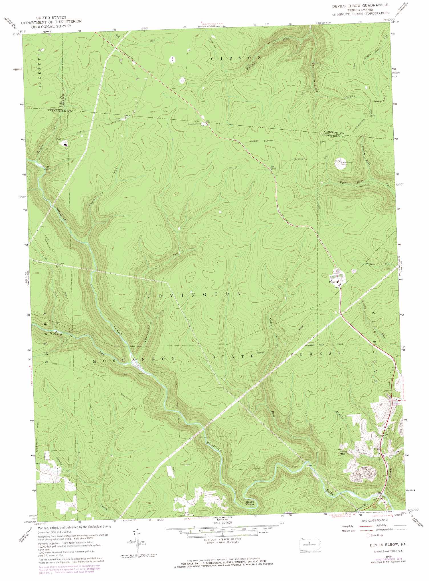
USGS Topo Quad 41078b2 - 1:24,000 scale
| Topo Map Name: | Devils Elbow |
| USGS Topo Quad ID: | 41078b2 |
| Print Size: | ca. 21 1/4" wide x 27" high |
| Southeast Coordinates: | 41.125° N latitude / 78.125° W longitude |
| Map Center Coordinates: | 41.1875° N latitude / 78.1875° W longitude |
| U.S. State: | PA |
| Filename: | o41078b2.jpg |
| Download Map JPG Image: | Devils Elbow topo map 1:24,000 scale |
| Map Type: | Topographic |
| Topo Series: | 7.5´ |
| Map Scale: | 1:24,000 |
| Source of Map Images: | United States Geological Survey (USGS) |
| Alternate Map Versions: |
Devils Elbow PA 1959, updated 1960 Download PDF Buy paper map Devils Elbow PA 1959, updated 1969 Download PDF Buy paper map Devils Elbow PA 1959, updated 1972 Download PDF Buy paper map Devils Elbow PA 1959, updated 1972 Download PDF Buy paper map Devils Elbow PA 2010 Download PDF Buy paper map Devils Elbow PA 2013 Download PDF Buy paper map Devils Elbow PA 2016 Download PDF Buy paper map |
1:24,000 Topo Quads surrounding Devils Elbow
Rathbun |
West Creek |
Cameron |
First Fork |
Hammersley Fork |
Weedville |
Dents Run |
Driftwood |
Sinnemahoning |
Keating |
Huntley |
The Knobs |
Devils Elbow |
Pottersdale |
Snow Shoe Nw |
Clearfield |
Lecontes Mills |
Frenchville |
Karthaus |
Snow Shoe |
Glen Richey |
Wallaceton |
Philipsburg |
Black Moshannon |
Bear Knob |
> Back to 41078a1 at 1:100,000 scale
> Back to 41078a1 at 1:250,000 scale
> Back to U.S. Topo Maps home
Devils Elbow topo map: Gazetteer
Devils Elbow: Areas
Wykoff Run State Forest Natural Area elevation 617m 2024′Devils Elbow: Bends
Devils Elbow elevation 338m 1108′Devils Elbow: Dams
Blackwell Dam (historical) elevation 467m 1532′Devils Elbow: Populated Places
Piper elevation 637m 2089′Devils Elbow: Streams
Arnold Run elevation 327m 1072′Big Sandy Run elevation 462m 1515′
Cole Run elevation 315m 1033′
Gifford Run elevation 393m 1289′
Gifford Run elevation 392m 1286′
Grimes Run elevation 293m 961′
Heichel Run elevation 352m 1154′
Lost Run elevation 438m 1437′
Meeker Run elevation 474m 1555′
Panther Run elevation 443m 1453′
Susman Run elevation 345m 1131′
Twelvemile Run elevation 396m 1299′
Devils Elbow: Summits
Arnold Mountain elevation 455m 1492′Devils Elbow: Trails
Big Spring Draft Trail elevation 530m 1738′Cherry Hollow Trail elevation 596m 1955′
Number Eleven Trail elevation 642m 2106′
Number Five Trail elevation 547m 1794′
Devils Elbow: Valleys
Big Spring Draft elevation 447m 1466′Dry Draft elevation 590m 1935′
Dry Draft elevation 495m 1624′
Dutch Hollow elevation 312m 1023′
Sanders Draft elevation 578m 1896′
Schnarr Draft elevation 544m 1784′
Devils Elbow digital topo map on disk
Buy this Devils Elbow topo map showing relief, roads, GPS coordinates and other geographical features, as a high-resolution digital map file on DVD:
 map DVD")