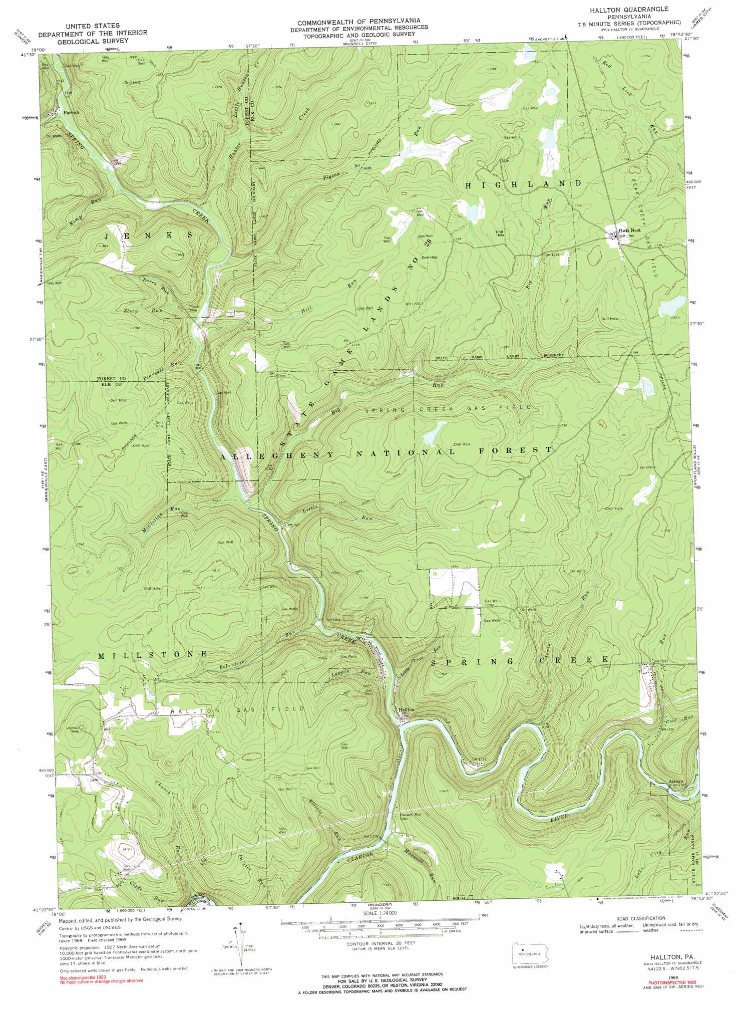
Hallton Topo Map Pennsylvania
To zoom in, hover over the map of Hallton
USGS Topo Quad 41078d8 - 1:24,000 scale
| Topo Map Name: | Hallton |
| USGS Topo Quad ID: | 41078d8 |
| Print Size: | ca. 21 1/4" wide x 27" high |
| Southeast Coordinates: | 41.375° N latitude / 78.875° W longitude |
| Map Center Coordinates: | 41.4375° N latitude / 78.9375° W longitude |
| U.S. State: | PA |
| Filename: | o41078d8.jpg |
| Download Map JPG Image: | Hallton topo map 1:24,000 scale |
| Map Type: | Topographic |
| Topo Series: | 7.5´ |
| Map Scale: | 1:24,000 |
| Source of Map Images: | United States Geological Survey (USGS) |
| Alternate Map Versions: |
Hallton PA 1969, updated 1972 Download PDF Buy paper map Hallton PA 1969, updated 1972 Download PDF Buy paper map Hallton PA 2011 Download PDF Buy paper map Hallton PA 2013 Download PDF Buy paper map Hallton PA 2016 Download PDF Buy paper map |
| FStopo: | US Forest Service topo Hallton is available: Download FStopo PDF Download FStopo TIF |
1:24,000 Topo Quads surrounding Hallton
Cherry Grove |
Sheffield |
Ludlow |
Kane |
Mount Jewett |
Mayburg |
Lynch |
Russell City |
James City |
Wilcox |
Marienville West |
Marienville East |
Hallton |
Portland Mills |
Ridgway |
Cooksburg |
Sigel |
Munderf |
Carman |
Brandy Camp |
Corsica |
Brookville |
Hazen |
Falls Creek |
Sabula |
> Back to 41078a1 at 1:100,000 scale
> Back to 41078a1 at 1:250,000 scale
> Back to U.S. Topo Maps home
Hallton topo map: Gazetteer
Hallton: Oilfields
Hallton Gas Field elevation 525m 1722′Spring Creek Gas Field elevation 546m 1791′
Hallton: Parks
State Game Lands Number 28 elevation 534m 1751′Hallton: Populated Places
Arroyo elevation 398m 1305′Beuhler Corner elevation 478m 1568′
Hallton elevation 400m 1312′
Owls Nest elevation 543m 1781′
Parrish elevation 427m 1400′
Hallton: Streams
Beech Bottom Run elevation 395m 1295′Belvidere Run elevation 392m 1286′
Big Run elevation 396m 1299′
Church Run elevation 378m 1240′
Cole Run elevation 409m 1341′
Crow Run elevation 395m 1295′
Elliott Run elevation 382m 1253′
Hill Run elevation 414m 1358′
Hunter Creek elevation 419m 1374′
Irwin Run elevation 392m 1286′
Kemp Run elevation 422m 1384′
Lake City Run elevation 390m 1279′
Lappin Run elevation 387m 1269′
Little Crow Run elevation 400m 1312′
Little Hunter Creek elevation 449m 1473′
Little Run elevation 403m 1322′
Maxwell Run elevation 382m 1253′
McClellan Run elevation 399m 1309′
Pearsall Run elevation 409m 1341′
Pigeon Run elevation 417m 1368′
Raven Run elevation 441m 1446′
Spring Creek elevation 380m 1246′
Steep Run elevation 413m 1354′
Wolf Run elevation 425m 1394′
Woodchuck Run elevation 449m 1473′
Hallton digital topo map on disk
Buy this Hallton topo map showing relief, roads, GPS coordinates and other geographical features, as a high-resolution digital map file on DVD:
 map DVD")