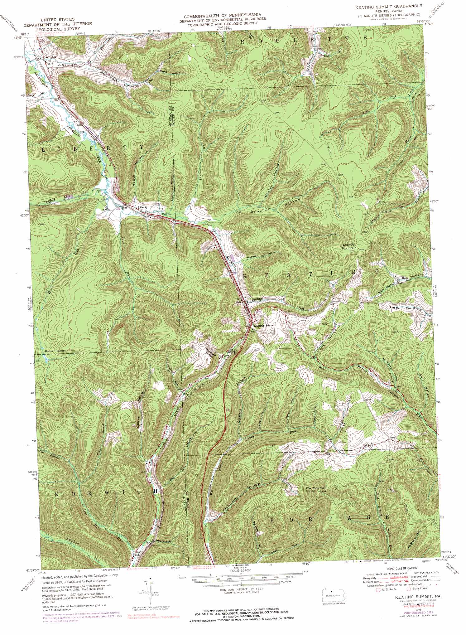
Keating Summit Topo Map Pennsylvania
To zoom in, hover over the map of Keating Summit
USGS Topo Quad 41078f2 - 1:24,000 scale
| Topo Map Name: | Keating Summit |
| USGS Topo Quad ID: | 41078f2 |
| Print Size: | ca. 21 1/4" wide x 27" high |
| Southeast Coordinates: | 41.625° N latitude / 78.125° W longitude |
| Map Center Coordinates: | 41.6875° N latitude / 78.1875° W longitude |
| U.S. State: | PA |
| Filename: | o41078f2.jpg |
| Download Map JPG Image: | Keating Summit topo map 1:24,000 scale |
| Map Type: | Topographic |
| Topo Series: | 7.5´ |
| Map Scale: | 1:24,000 |
| Source of Map Images: | United States Geological Survey (USGS) |
| Alternate Map Versions: |
Keating Summit PA 1948, updated 1958 Download PDF Buy paper map Keating Summit PA 1948, updated 1972 Download PDF Buy paper map Keating Summit PA 1948, updated 1990 Download PDF Buy paper map Keating Summit PA 1950 Download PDF Buy paper map Keating Summit PA 1950, updated 1950 Download PDF Buy paper map Keating Summit PA 2010 Download PDF Buy paper map Keating Summit PA 2013 Download PDF Buy paper map Keating Summit PA 2016 Download PDF Buy paper map |
1:24,000 Topo Quads surrounding Keating Summit
Eldred |
Bullis Mills |
Shinglehouse |
Oswayo |
Ellisburg |
Smethport |
Port Allegany |
Roulette |
Coudersport |
Sweden Valley |
Crosby |
Norwich |
Keating Summit |
Austin |
Ayers Hill |
Wildwood Fire Tower |
Rich Valley |
Emporium |
Wharton |
Conrad |
Rathbun |
West Creek |
Cameron |
First Fork |
Hammersley Fork |
> Back to 41078e1 at 1:100,000 scale
> Back to 41078a1 at 1:250,000 scale
> Back to U.S. Topo Maps home
Keating Summit topo map: Gazetteer
Keating Summit: Populated Places
Keating Summit elevation 583m 1912′Liberty elevation 500m 1640′
Wrights elevation 479m 1571′
Keating Summit: Streams
Dempsey Run elevation 505m 1656′Fair Run elevation 495m 1624′
Half Mile Run elevation 404m 1325′
Hamilton Run elevation 471m 1545′
Indian Run elevation 505m 1656′
Left Branch Half Mile Run elevation 474m 1555′
Right Branch Half Mile Run elevation 463m 1519′
Right Fork Reed Run elevation 528m 1732′
Rock Run elevation 493m 1617′
Scaffold Lick Run elevation 492m 1614′
Slide Hollow Branch elevation 517m 1696′
South Branch Hamilton Run elevation 496m 1627′
Whiting Creek elevation 553m 1814′
Keating Summit: Summits
Fox Mountain elevation 734m 2408′Lookout Mountain elevation 754m 2473′
Lookout Mountain Overlook elevation 739m 2424′
Keating Summit: Trails
Brown Hollow Number 1 Trail elevation 651m 2135′Brown Hollow Number 2 Trail elevation 561m 1840′
Brown Hollow Number 3 Trail elevation 670m 2198′
Keating Summit: Valleys
Andrew Hollow elevation 555m 1820′Big Fill Hollow elevation 450m 1476′
Brown Hollow elevation 518m 1699′
Buck Hollow elevation 500m 1640′
Buckbee Hollow elevation 439m 1440′
Bush Hollow elevation 526m 1725′
Cady Hollow elevation 475m 1558′
Camp Hollow elevation 568m 1863′
Cannon Hollow elevation 457m 1499′
County Line Hollow elevation 519m 1702′
Crawford Hollow elevation 493m 1617′
Culver Hollow elevation 505m 1656′
Healey Hollow elevation 547m 1794′
Heath Hollow elevation 505m 1656′
Little Fill Hollow elevation 432m 1417′
McCurvey Hollow elevation 523m 1715′
McLaughlin Hollow elevation 535m 1755′
Mitcheltree Hollow elevation 546m 1791′
Planing Mill Hollow elevation 549m 1801′
Reese Hollow elevation 547m 1794′
Slabtown Hollow elevation 445m 1459′
Smith Hollow elevation 639m 2096′
Keating Summit digital topo map on disk
Buy this Keating Summit topo map showing relief, roads, GPS coordinates and other geographical features, as a high-resolution digital map file on DVD:
 map DVD")