Roulette Topo Map Pennsylvania
To zoom in, hover over the map of Roulette
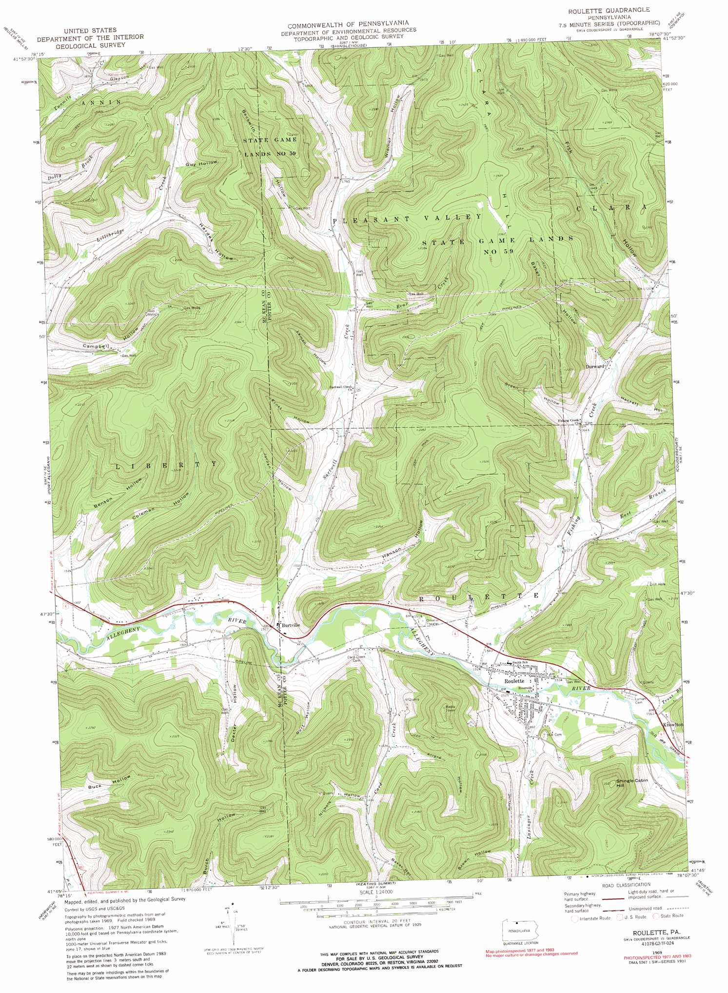
USGS Topo Quad 41078g2 - 1:24,000 scale
| Topo Map Name: | Roulette |
| USGS Topo Quad ID: | 41078g2 |
| Print Size: | ca. 21 1/4" wide x 27" high |
| Southeast Coordinates: | 41.75° N latitude / 78.125° W longitude |
| Map Center Coordinates: | 41.8125° N latitude / 78.1875° W longitude |
| U.S. State: | PA |
| Filename: | o41078g2.jpg |
| Download Map JPG Image: | Roulette topo map 1:24,000 scale |
| Map Type: | Topographic |
| Topo Series: | 7.5´ |
| Map Scale: | 1:24,000 |
| Source of Map Images: | United States Geological Survey (USGS) |
| Alternate Map Versions: |
Roulette PA 1969, updated 1972 Download PDF Buy paper map Roulette PA 1969, updated 1980 Download PDF Buy paper map Roulette PA 1969, updated 1989 Download PDF Buy paper map Roulette PA 1969, updated 1989 Download PDF Buy paper map Roulette PA 2010 Download PDF Buy paper map Roulette PA 2013 Download PDF Buy paper map Roulette PA 2016 Download PDF Buy paper map |
1:24,000 Topo Quads surrounding Roulette
Olean |
Portville |
Bolivar |
Allentown |
Wellsville South |
Eldred |
Bullis Mills |
Shinglehouse |
Oswayo |
Ellisburg |
Smethport |
Port Allegany |
Roulette |
Coudersport |
Sweden Valley |
Crosby |
Norwich |
Keating Summit |
Austin |
Ayers Hill |
Wildwood Fire Tower |
Rich Valley |
Emporium |
Wharton |
Conrad |
> Back to 41078e1 at 1:100,000 scale
> Back to 41078a1 at 1:250,000 scale
> Back to U.S. Topo Maps home
Roulette topo map: Gazetteer
Roulette: Parks
State Game Lands Number 59 elevation 726m 2381′Roulette: Populated Places
Burtville elevation 460m 1509′Durward elevation 510m 1673′
Knowlton elevation 480m 1574′
Roulette elevation 466m 1528′
Williston elevation 510m 1673′
Roulette: Streams
Bear Creek elevation 518m 1699′Buck Run elevation 686m 2250′
Card Creek elevation 462m 1515′
Coleman Creek elevation 451m 1479′
East Branch Fishing Creek elevation 482m 1581′
Fishing Creek elevation 463m 1519′
Fisk Hollow Run elevation 523m 1715′
Laninger Creek elevation 467m 1532′
Sartwell Creek elevation 457m 1499′
Trout Brook elevation 470m 1541′
Roulette: Summits
Clara Hill elevation 740m 2427′Shingle Cabin Hill elevation 706m 2316′
Roulette: Valleys
Allard Hollow elevation 499m 1637′Baker Hollow elevation 551m 1807′
Baker Hollow elevation 516m 1692′
Beckwith Hollow elevation 527m 1729′
Benson Hollow elevation 463m 1519′
Brown Hollow elevation 521m 1709′
Burch Hollow elevation 529m 1735′
Burt Hollow elevation 468m 1535′
Coleman Hollow elevation 463m 1519′
Dexter Hollow elevation 464m 1522′
Ernst Hollow elevation 488m 1601′
Fisk Hollow elevation 525m 1722′
Gleason Hollow elevation 547m 1794′
Green Hollow elevation 505m 1656′
Guy Hollow elevation 556m 1824′
Hackett Hollow elevation 508m 1666′
Hanson Hollow elevation 469m 1538′
Hardes Hollow elevation 544m 1784′
Jordan Hollow elevation 482m 1581′
Leman Hollow elevation 501m 1643′
Meacham Hollow elevation 474m 1555′
Nichols Hollow elevation 517m 1696′
Wiemer Hollow elevation 536m 1758′
Roulette digital topo map on disk
Buy this Roulette topo map showing relief, roads, GPS coordinates and other geographical features, as a high-resolution digital map file on DVD:
 map DVD")