Lewis Run Topo Map Pennsylvania
To zoom in, hover over the map of Lewis Run
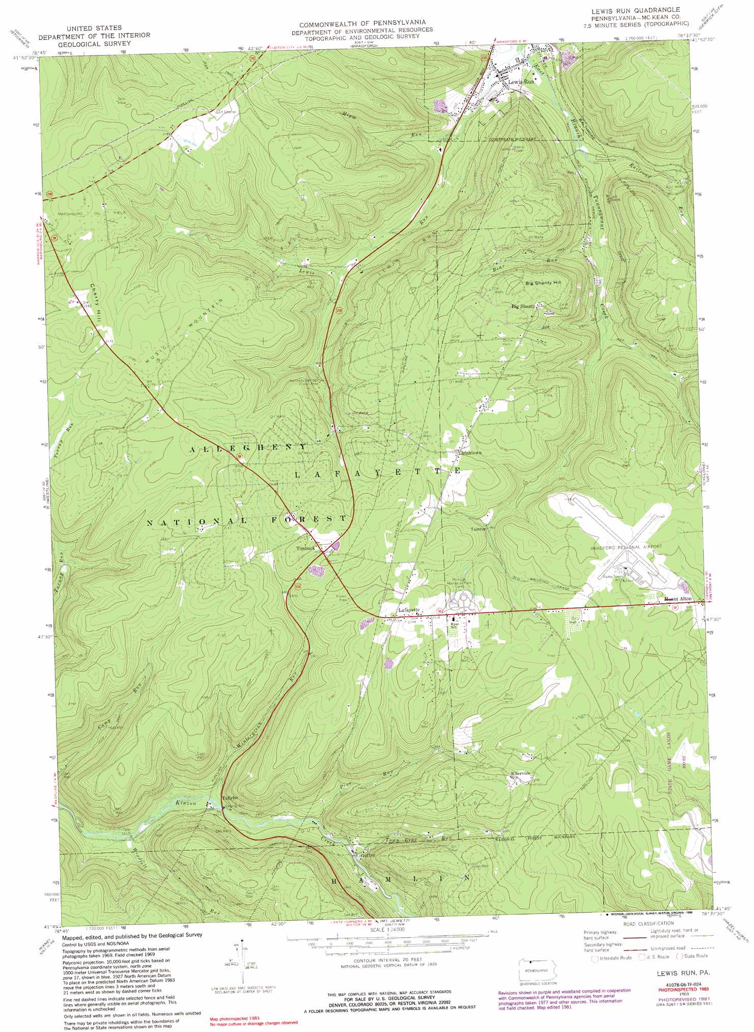
USGS Topo Quad 41078g6 - 1:24,000 scale
| Topo Map Name: | Lewis Run |
| USGS Topo Quad ID: | 41078g6 |
| Print Size: | ca. 21 1/4" wide x 27" high |
| Southeast Coordinates: | 41.75° N latitude / 78.625° W longitude |
| Map Center Coordinates: | 41.8125° N latitude / 78.6875° W longitude |
| U.S. State: | PA |
| Filename: | o41078g6.jpg |
| Download Map JPG Image: | Lewis Run topo map 1:24,000 scale |
| Map Type: | Topographic |
| Topo Series: | 7.5´ |
| Map Scale: | 1:24,000 |
| Source of Map Images: | United States Geological Survey (USGS) |
| Alternate Map Versions: |
Lewis Run PA 1969, updated 1972 Download PDF Buy paper map Lewis Run PA 1969, updated 1981 Download PDF Buy paper map Lewis Run PA 1969, updated 1988 Download PDF Buy paper map Lewis Run PA 2011 Download PDF Buy paper map Lewis Run PA 2013 Download PDF Buy paper map Lewis Run PA 2016 Download PDF Buy paper map |
| FStopo: | US Forest Service topo Lewis Run is available: Download FStopo PDF Download FStopo TIF |
1:24,000 Topo Quads surrounding Lewis Run
Steamburg |
Red House |
Limestone |
Knapp Creek |
Olean |
Cornplanter Run |
Stickney |
Bradford |
Derrick City |
Eldred |
Cornplanter Bridge |
Westline |
Lewis Run |
Cyclone |
Smethport |
Ludlow |
Kane |
Mount Jewett |
Hazel Hurst |
Crosby |
Russell City |
James City |
Wilcox |
Glen Hazel |
Wildwood Fire Tower |
> Back to 41078e1 at 1:100,000 scale
> Back to 41078a1 at 1:250,000 scale
> Back to U.S. Topo Maps home
Lewis Run topo map: Gazetteer
Lewis Run: Airports
Bradford Regional Airport elevation 645m 2116′Lewis Run: Oilfields
Lewis Run Oil Field elevation 568m 1863′Marshburg Oil Field elevation 657m 2155′
Music Mountain Oil Field elevation 669m 2194′
Lewis Run: Parks
State Game Lands Number Sixty Two elevation 625m 2050′Lewis Run: Populated Places
Big Shanty elevation 639m 2096′Guffey elevation 487m 1597′
Irishtown elevation 641m 2103′
Lafayette elevation 653m 2142′
Lewis Run elevation 473m 1551′
Mount Alton elevation 631m 2070′
Riterville elevation 642m 2106′
Taintor elevation 598m 1961′
Tallyho elevation 475m 1558′
Timbuck elevation 634m 2080′
Lewis Run: Streams
Bear Run elevation 500m 1640′Droney Run elevation 524m 1719′
Elk Bar Run elevation 478m 1568′
Lewis Run elevation 469m 1538′
Lewis Run elevation 469m 1538′
Miam Run elevation 480m 1574′
Pine Run elevation 480m 1574′
Railroad Run elevation 483m 1584′
Town Line Run elevation 487m 1597′
Windfall Run elevation 463m 1519′
Wintergreen Run elevation 473m 1551′
Lewis Run: Summits
Big Shanty Hill elevation 671m 2201′Cherry Hill elevation 672m 2204′
Lewis Run: Valleys
Lewis Hollow elevation 491m 1610′Miam Hollow elevation 504m 1653′
Lewis Run digital topo map on disk
Buy this Lewis Run topo map showing relief, roads, GPS coordinates and other geographical features, as a high-resolution digital map file on DVD:
 map DVD")