Hilliards Topo Map Pennsylvania
To zoom in, hover over the map of Hilliards
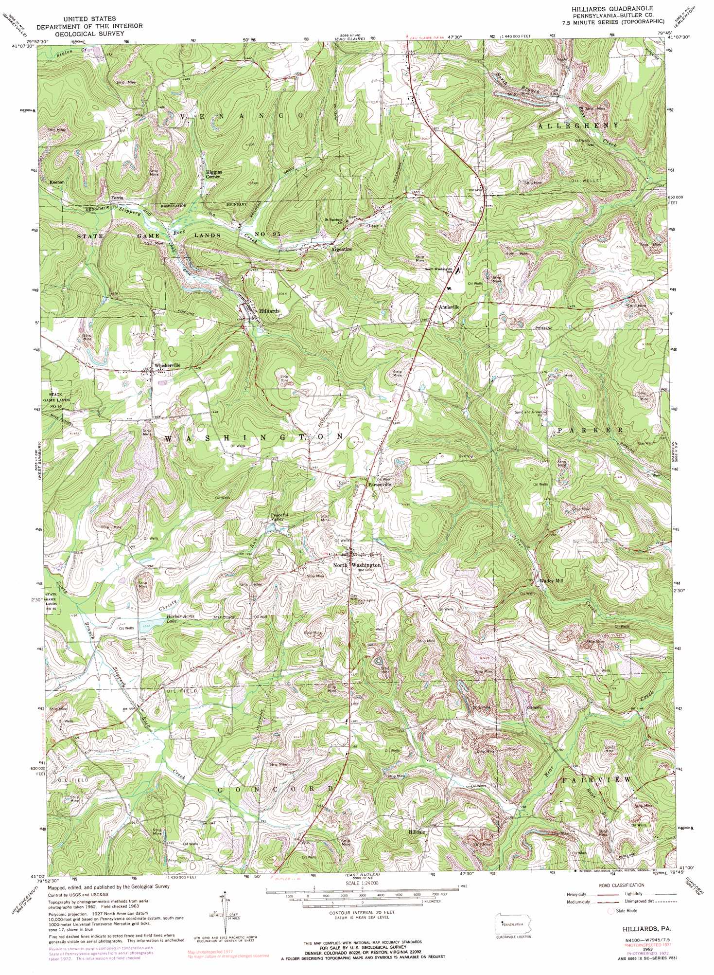
USGS Topo Quad 41079a7 - 1:24,000 scale
| Topo Map Name: | Hilliards |
| USGS Topo Quad ID: | 41079a7 |
| Print Size: | ca. 21 1/4" wide x 27" high |
| Southeast Coordinates: | 41° N latitude / 79.75° W longitude |
| Map Center Coordinates: | 41.0625° N latitude / 79.8125° W longitude |
| U.S. State: | PA |
| Filename: | o41079a7.jpg |
| Download Map JPG Image: | Hilliards topo map 1:24,000 scale |
| Map Type: | Topographic |
| Topo Series: | 7.5´ |
| Map Scale: | 1:24,000 |
| Source of Map Images: | United States Geological Survey (USGS) |
| Alternate Map Versions: |
Hilliards PA 1963, updated 1965 Download PDF Buy paper map Hilliards PA 1963, updated 1971 Download PDF Buy paper map Hilliards PA 1963, updated 1973 Download PDF Buy paper map Hilliards PA 1963, updated 1991 Download PDF Buy paper map Hilliards PA 2010 Download PDF Buy paper map Hilliards PA 2013 Download PDF Buy paper map Hilliards PA 2016 Download PDF Buy paper map |
1:24,000 Topo Quads surrounding Hilliards
Sandy Lake |
Polk |
Kennerdell |
Cranberry |
Kossuth |
Grove City |
Barkeyville |
Eau Claire |
Emlenton |
Knox |
Slippery Rock |
West Sunbury |
Hilliards |
Parker |
Rimersburg |
Prospect |
Mount Chestnut |
East Butler |
Chicora |
East Brady |
Evans City |
Butler |
Saxonburg |
Worthington |
Kittanning |
> Back to 41079a1 at 1:100,000 scale
> Back to 41078a1 at 1:250,000 scale
> Back to U.S. Topo Maps home
Hilliards topo map: Gazetteer
Hilliards: Lakes
Harbar Acres Lake elevation 369m 1210′Hilliards: Populated Places
Annisville elevation 452m 1482′Argentine elevation 385m 1263′
Ferris elevation 370m 1213′
Higgins Corner elevation 384m 1259′
Hilldale elevation 418m 1371′
Hilliards elevation 389m 1276′
Keenan elevation 385m 1263′
North Washington elevation 460m 1509′
Parsonville elevation 452m 1482′
Peaceful Valley elevation 392m 1286′
Walley Mill elevation 361m 1184′
Whiskerville elevation 453m 1486′
Hilliards: Streams
Christy Run elevation 366m 1200′Rays Run elevation 350m 1148′
Hilliards digital topo map on disk
Buy this Hilliards topo map showing relief, roads, GPS coordinates and other geographical features, as a high-resolution digital map file on DVD:
 map DVD")