Eau Claire Topo Map Pennsylvania
To zoom in, hover over the map of Eau Claire
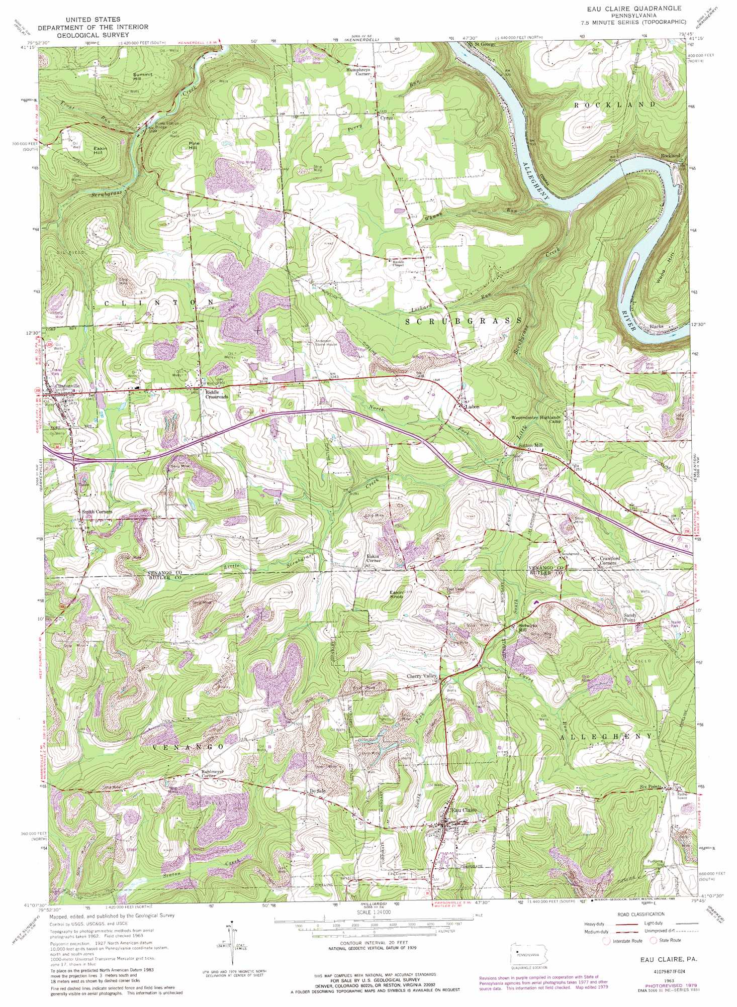
USGS Topo Quad 41079b7 - 1:24,000 scale
| Topo Map Name: | Eau Claire |
| USGS Topo Quad ID: | 41079b7 |
| Print Size: | ca. 21 1/4" wide x 27" high |
| Southeast Coordinates: | 41.125° N latitude / 79.75° W longitude |
| Map Center Coordinates: | 41.1875° N latitude / 79.8125° W longitude |
| U.S. State: | PA |
| Filename: | o41079b7.jpg |
| Download Map JPG Image: | Eau Claire topo map 1:24,000 scale |
| Map Type: | Topographic |
| Topo Series: | 7.5´ |
| Map Scale: | 1:24,000 |
| Source of Map Images: | United States Geological Survey (USGS) |
| Alternate Map Versions: |
Eau Claire PA 1963, updated 1965 Download PDF Buy paper map Eau Claire PA 1963, updated 1973 Download PDF Buy paper map Eau Claire PA 1963, updated 1979 Download PDF Buy paper map Eau Claire PA 1963, updated 1989 Download PDF Buy paper map Eau Claire PA 1963, updated 1989 Download PDF Buy paper map Eau Claire PA 2010 Download PDF Buy paper map Eau Claire PA 2013 Download PDF Buy paper map Eau Claire PA 2016 Download PDF Buy paper map |
1:24,000 Topo Quads surrounding Eau Claire
New Lebanon |
Utica |
Franklin |
Oil City |
President |
Sandy Lake |
Polk |
Kennerdell |
Cranberry |
Kossuth |
Grove City |
Barkeyville |
Eau Claire |
Emlenton |
Knox |
Slippery Rock |
West Sunbury |
Hilliards |
Parker |
Rimersburg |
Prospect |
Mount Chestnut |
East Butler |
Chicora |
East Brady |
> Back to 41079a1 at 1:100,000 scale
> Back to 41078a1 at 1:250,000 scale
> Back to U.S. Topo Maps home
Eau Claire topo map: Gazetteer
Eau Claire: Dams
Johnston Dam elevation 417m 1368′Eau Claire: Mines
Annandale Sandstone Quarry elevation 389m 1276′Eau Claire: Populated Places
Blacks elevation 278m 912′Cherry Valley elevation 405m 1328′
Clintonville elevation 434m 1423′
Crawford Corners elevation 440m 1443′
Cyrus elevation 408m 1338′
De Sale elevation 439m 1440′
Eakin Corner elevation 421m 1381′
Eau Claire elevation 463m 1519′
Humphreys Corner elevation 417m 1368′
Kohlmeyer Corner elevation 464m 1522′
Lisbon elevation 410m 1345′
Pine Grove elevation 385m 1263′
Riddle Crossroads elevation 443m 1453′
Rockland elevation 285m 935′
Sandy Point elevation 440m 1443′
Sedwicks Mill elevation 390m 1279′
Six Points elevation 466m 1528′
Smith Corners elevation 449m 1473′
Sutton Mill elevation 379m 1243′
Eau Claire: Reservoirs
Lake Johnston elevation 417m 1368′Eau Claire: Streams
Carrs Run elevation 390m 1279′Little Scrubgrass Creek elevation 274m 898′
Lockard Run elevation 294m 964′
North Fork Little Scrubgrass Creek elevation 363m 1190′
Perry Run elevation 272m 892′
Shull Run elevation 271m 889′
South Fork Little Scrubgrass Creek elevation 358m 1174′
Trout Run elevation 311m 1020′
Whann Run elevation 272m 892′
Eau Claire: Summits
Eakin Hill elevation 440m 1443′Eakin Knob elevation 475m 1558′
Pine Hill elevation 440m 1443′
Summit Hill elevation 433m 1420′
Wood Hill elevation 399m 1309′
Eau Claire digital topo map on disk
Buy this Eau Claire topo map showing relief, roads, GPS coordinates and other geographical features, as a high-resolution digital map file on DVD:
 map DVD")