Cranberry Topo Map Pennsylvania
To zoom in, hover over the map of Cranberry
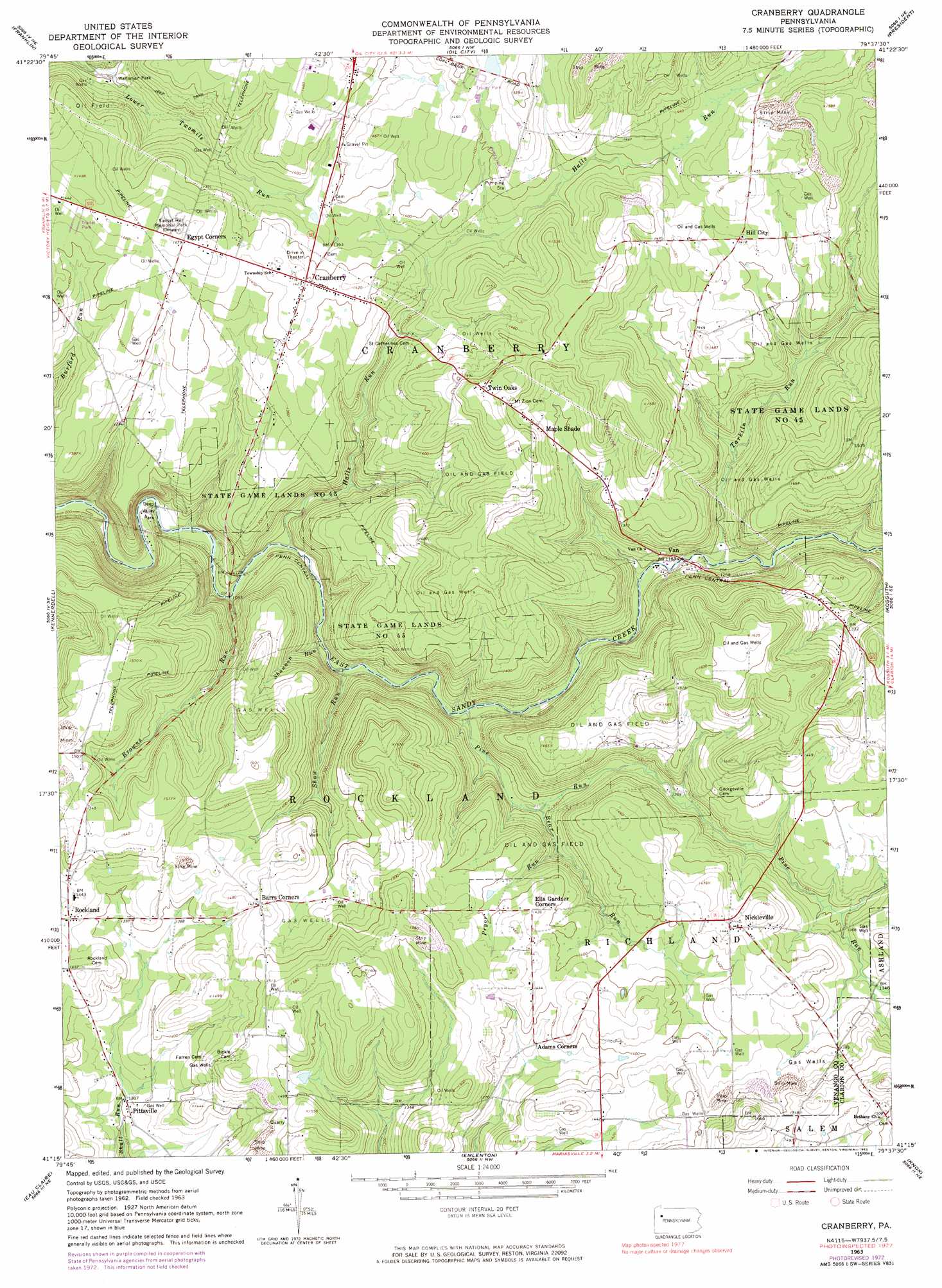
USGS Topo Quad 41079c6 - 1:24,000 scale
| Topo Map Name: | Cranberry |
| USGS Topo Quad ID: | 41079c6 |
| Print Size: | ca. 21 1/4" wide x 27" high |
| Southeast Coordinates: | 41.25° N latitude / 79.625° W longitude |
| Map Center Coordinates: | 41.3125° N latitude / 79.6875° W longitude |
| U.S. State: | PA |
| Filename: | o41079c6.jpg |
| Download Map JPG Image: | Cranberry topo map 1:24,000 scale |
| Map Type: | Topographic |
| Topo Series: | 7.5´ |
| Map Scale: | 1:24,000 |
| Source of Map Images: | United States Geological Survey (USGS) |
| Alternate Map Versions: |
Cranberry PA 1963, updated 1965 Download PDF Buy paper map Cranberry PA 1963, updated 1973 Download PDF Buy paper map Cranberry PA 1963, updated 1983 Download PDF Buy paper map Cranberry PA 2010 Download PDF Buy paper map Cranberry PA 2013 Download PDF Buy paper map Cranberry PA 2016 Download PDF Buy paper map |
1:24,000 Topo Quads surrounding Cranberry
Sugar Lake |
Dempseytown |
Titusville South |
Pleasantville |
West Hickory |
Utica |
Franklin |
Oil City |
President |
Tionesta |
Polk |
Kennerdell |
Cranberry |
Kossuth |
Fryburg |
Barkeyville |
Eau Claire |
Emlenton |
Knox |
Clarion |
West Sunbury |
Hilliards |
Parker |
Rimersburg |
Sligo |
> Back to 41079a1 at 1:100,000 scale
> Back to 41078a1 at 1:250,000 scale
> Back to U.S. Topo Maps home
Cranberry topo map: Gazetteer
Cranberry: Airports
Seneca Airpark elevation 442m 1450′Seneca Airport elevation 434m 1423′
Cranberry: Parks
Bissel Park (historical) elevation 430m 1410′State Game Lands Number 45 elevation 433m 1420′
Waltonian Park elevation 361m 1184′
Cranberry: Populated Places
Barrs Corners elevation 449m 1473′Cranberry elevation 432m 1417′
Egypt Corners elevation 452m 1482′
Hill City elevation 432m 1417′
Maple Shade elevation 432m 1417′
Nickleville elevation 443m 1453′
Pittsville elevation 399m 1309′
Rockland elevation 436m 1430′
Twin Oaks elevation 473m 1551′
Van elevation 362m 1187′
Cranberry: Post Offices
Cass Post Office (historical) elevation 365m 1197′Cranberry Post Office (historical) elevation 436m 1430′
Pittsville Post Office (historical) elevation 406m 1332′
Rockland Post Office (historical) elevation 448m 1469′
Cranberry: Streams
Bear Run elevation 367m 1204′Browns Run elevation 338m 1108′
Halls Run elevation 339m 1112′
Pine Run elevation 355m 1164′
Pryor Run elevation 384m 1259′
Pryor Run elevation 358m 1174′
Shannon Run elevation 347m 1138′
Shaw Run elevation 343m 1125′
Tarkiln Run elevation 366m 1200′
Cranberry digital topo map on disk
Buy this Cranberry topo map showing relief, roads, GPS coordinates and other geographical features, as a high-resolution digital map file on DVD:
 map DVD")