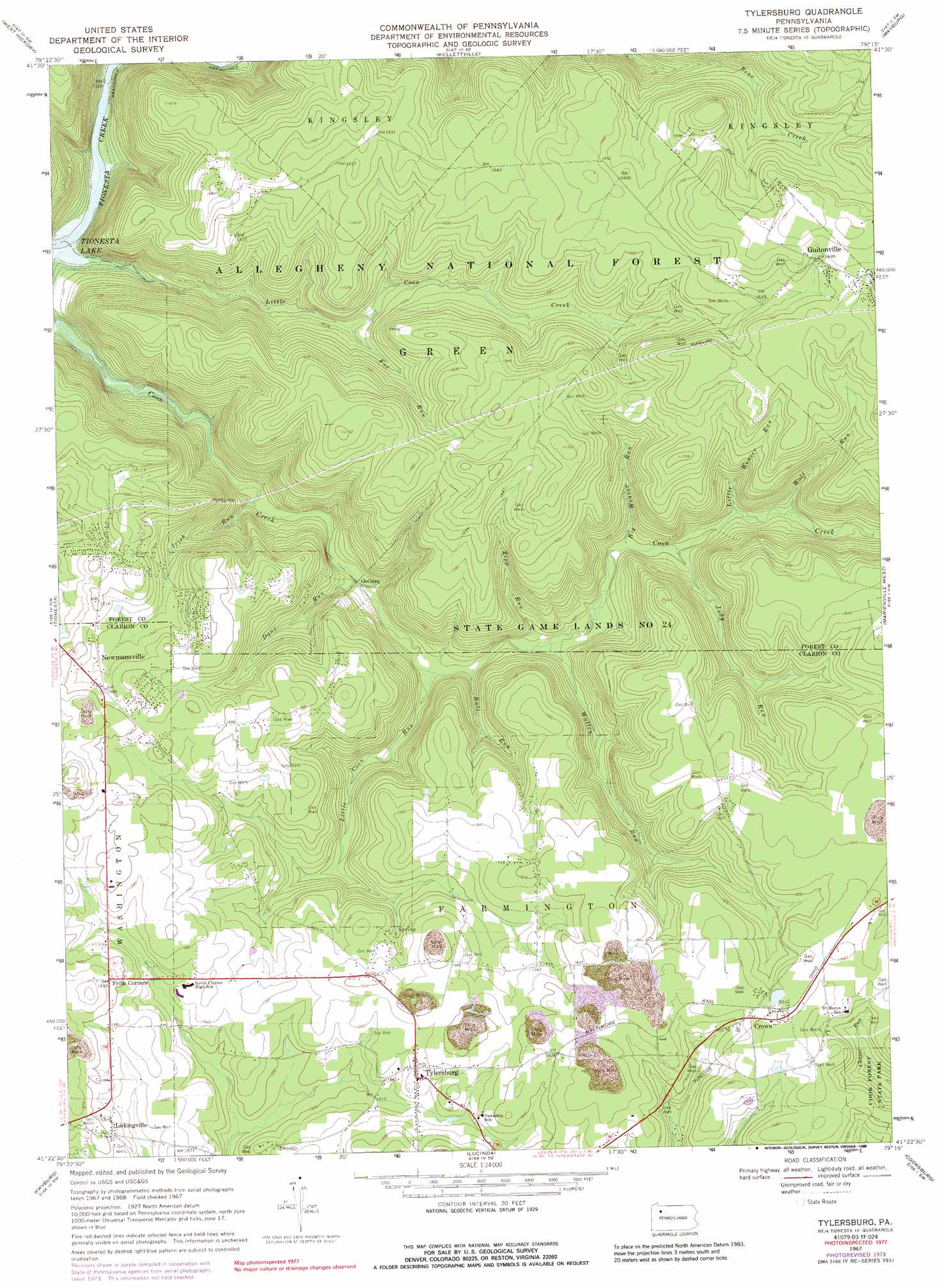
Tylersburg Topo Map Pennsylvania
To zoom in, hover over the map of Tylersburg
USGS Topo Quad 41079d3 - 1:24,000 scale
| Topo Map Name: | Tylersburg |
| USGS Topo Quad ID: | 41079d3 |
| Print Size: | ca. 21 1/4" wide x 27" high |
| Southeast Coordinates: | 41.375° N latitude / 79.25° W longitude |
| Map Center Coordinates: | 41.4375° N latitude / 79.3125° W longitude |
| U.S. State: | PA |
| Filename: | o41079d3.jpg |
| Download Map JPG Image: | Tylersburg topo map 1:24,000 scale |
| Map Type: | Topographic |
| Topo Series: | 7.5´ |
| Map Scale: | 1:24,000 |
| Source of Map Images: | United States Geological Survey (USGS) |
| Alternate Map Versions: |
Tylersburg PA 1967, updated 1971 Download PDF Buy paper map Tylersburg PA 1967, updated 1973 Download PDF Buy paper map Tylersburg PA 1967, updated 1988 Download PDF Buy paper map Tylersburg PA 1967, updated 1988 Download PDF Buy paper map Tylersburg PA 2011 Download PDF Buy paper map Tylersburg PA 2013 Download PDF Buy paper map Tylersburg PA 2016 Download PDF Buy paper map |
| FStopo: | US Forest Service topo Tylersburg is available: Download FStopo PDF Download FStopo TIF |
1:24,000 Topo Quads surrounding Tylersburg
Grand Valley |
Tidioute |
Cobham |
Cherry Grove |
Sheffield |
Pleasantville |
West Hickory |
Kellettville |
Mayburg |
Lynch |
President |
Tionesta |
Tylersburg |
Marienville West |
Marienville East |
Kossuth |
Fryburg |
Lucinda |
Cooksburg |
Sigel |
Knox |
Clarion |
Strattanville |
Corsica |
Brookville |
> Back to 41079a1 at 1:100,000 scale
> Back to 41078a1 at 1:250,000 scale
> Back to U.S. Topo Maps home
Tylersburg topo map: Gazetteer
Tylersburg: Airports
Armitage Newmansville Airport elevation 490m 1607′Tylersburg: Parks
State Game Lands Number 24 elevation 481m 1578′Tylersburg: Populated Places
Crown elevation 502m 1646′Frills Corners elevation 494m 1620′
Golinza elevation 371m 1217′
Guitonville elevation 516m 1692′
Lickingville elevation 485m 1591′
Newmansville elevation 482m 1581′
Tylersburg elevation 476m 1561′
Tylersburg: Streams
Big Weaver Run elevation 394m 1292′Bull Run elevation 377m 1236′
Dans Run elevation 371m 1217′
Fox Run elevation 408m 1338′
Irish Run elevation 361m 1184′
Judy Run elevation 394m 1292′
Little Coon Creek elevation 335m 1099′
Little Coon Run elevation 377m 1236′
Little Weaver Run elevation 401m 1315′
Walley Run elevation 383m 1256′
Wolf Run elevation 405m 1328′
Zipp Run elevation 383m 1256′
Tylersburg digital topo map on disk
Buy this Tylersburg topo map showing relief, roads, GPS coordinates and other geographical features, as a high-resolution digital map file on DVD:
 map DVD")