Utica Topo Map Pennsylvania
To zoom in, hover over the map of Utica
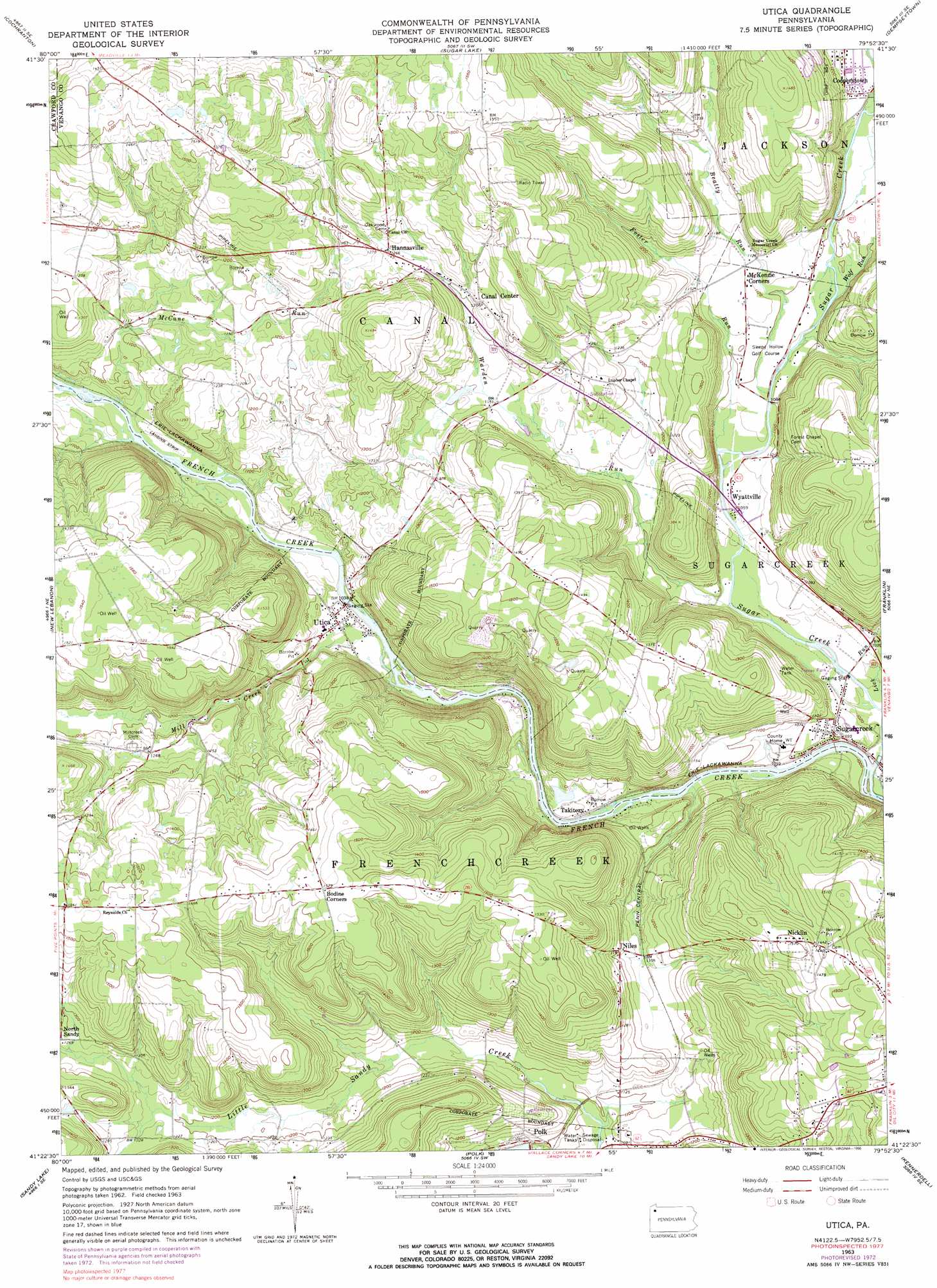
USGS Topo Quad 41079d8 - 1:24,000 scale
| Topo Map Name: | Utica |
| USGS Topo Quad ID: | 41079d8 |
| Print Size: | ca. 21 1/4" wide x 27" high |
| Southeast Coordinates: | 41.375° N latitude / 79.875° W longitude |
| Map Center Coordinates: | 41.4375° N latitude / 79.9375° W longitude |
| U.S. State: | PA |
| Filename: | o41079d8.jpg |
| Download Map JPG Image: | Utica topo map 1:24,000 scale |
| Map Type: | Topographic |
| Topo Series: | 7.5´ |
| Map Scale: | 1:24,000 |
| Source of Map Images: | United States Geological Survey (USGS) |
| Alternate Map Versions: |
Utica PA 1963, updated 1964 Download PDF Buy paper map Utica PA 1963, updated 1973 Download PDF Buy paper map Utica PA 1963, updated 1973 Download PDF Buy paper map Utica PA 1963, updated 1984 Download PDF Buy paper map Utica PA 1963, updated 1990 Download PDF Buy paper map Utica PA 2010 Download PDF Buy paper map Utica PA 2013 Download PDF Buy paper map Utica PA 2016 Download PDF Buy paper map |
1:24,000 Topo Quads surrounding Utica
Meadville |
Blooming Valley |
Townville |
Centerville |
Titusville North |
Geneva |
Cochranton |
Sugar Lake |
Dempseytown |
Titusville South |
Hadley |
New Lebanon |
Utica |
Franklin |
Oil City |
Jackson Center |
Sandy Lake |
Polk |
Kennerdell |
Cranberry |
Mercer |
Grove City |
Barkeyville |
Eau Claire |
Emlenton |
> Back to 41079a1 at 1:100,000 scale
> Back to 41078a1 at 1:250,000 scale
> Back to U.S. Topo Maps home
Utica topo map: Gazetteer
Utica: Airports
Port Engel Airport elevation 323m 1059′Port Roydel Airport elevation 401m 1315′
Utica: Dams
Polk Dam elevation 333m 1092′Utica: Populated Places
Canal Center elevation 390m 1279′Hannasville elevation 385m 1263′
Nicklin elevation 447m 1466′
Niles elevation 371m 1217′
North Sandy elevation 392m 1286′
Sugarcreek elevation 316m 1036′
Takitezy elevation 316m 1036′
Utica elevation 320m 1049′
Wyattville elevation 330m 1082′
Utica: Post Offices
Utica Post Office (historical) elevation 323m 1059′Utica: Reservoirs
Polk Dam Lake elevation 333m 1092′Utica: Streams
Beatty Run elevation 335m 1099′Foster Run elevation 343m 1125′
Lick Run elevation 313m 1026′
McCune Run elevation 315m 1033′
Mill Creek elevation 306m 1003′
Sugar Creek elevation 307m 1007′
Warden Run elevation 326m 1069′
Wolf Run elevation 357m 1171′
Utica digital topo map on disk
Buy this Utica topo map showing relief, roads, GPS coordinates and other geographical features, as a high-resolution digital map file on DVD:
 map DVD")