Dempseytown Topo Map Pennsylvania
To zoom in, hover over the map of Dempseytown
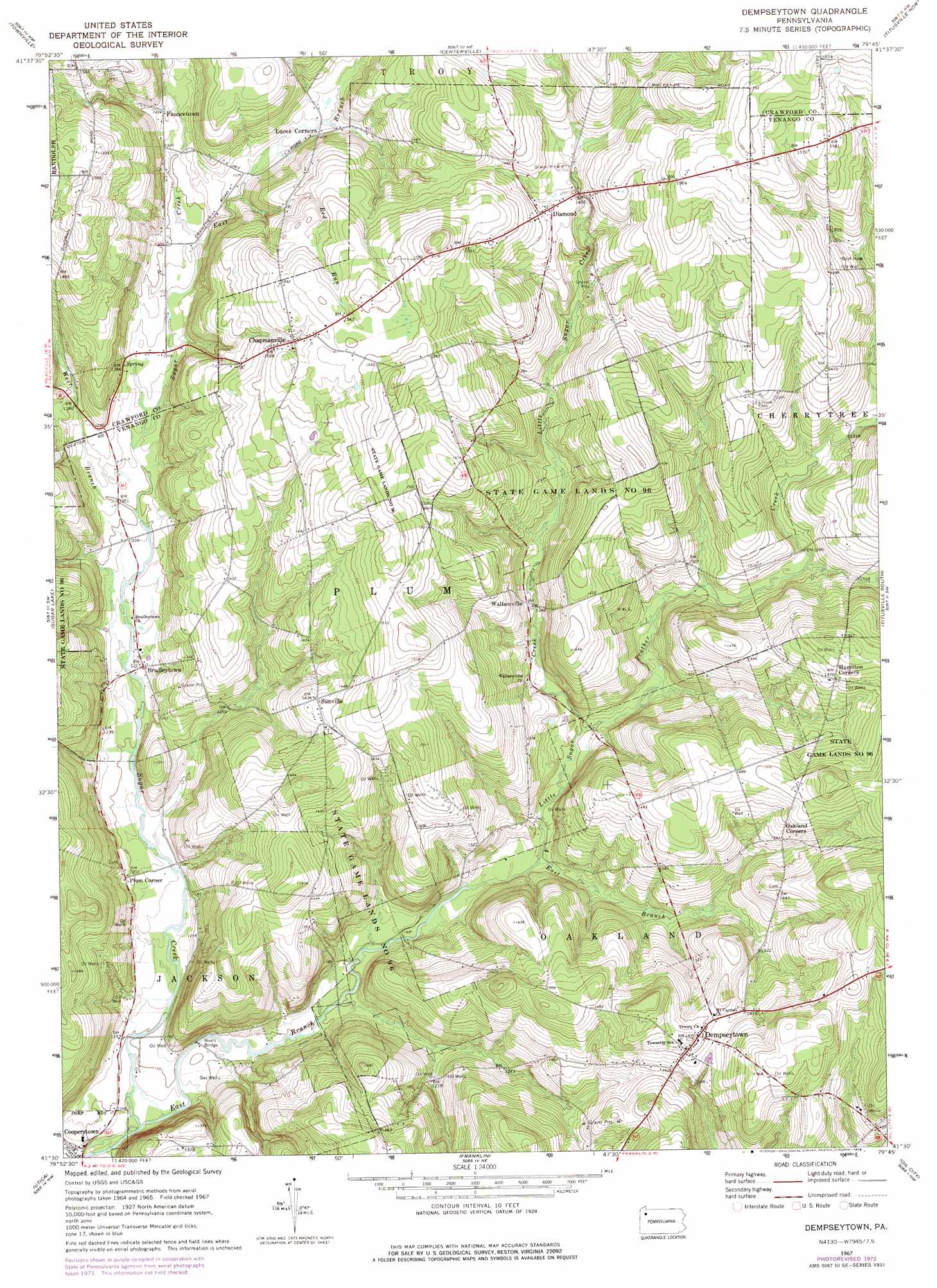
USGS Topo Quad 41079e7 - 1:24,000 scale
| Topo Map Name: | Dempseytown |
| USGS Topo Quad ID: | 41079e7 |
| Print Size: | ca. 21 1/4" wide x 27" high |
| Southeast Coordinates: | 41.5° N latitude / 79.75° W longitude |
| Map Center Coordinates: | 41.5625° N latitude / 79.8125° W longitude |
| U.S. State: | PA |
| Filename: | o41079e7.jpg |
| Download Map JPG Image: | Dempseytown topo map 1:24,000 scale |
| Map Type: | Topographic |
| Topo Series: | 7.5´ |
| Map Scale: | 1:24,000 |
| Source of Map Images: | United States Geological Survey (USGS) |
| Alternate Map Versions: |
Dempseytown PA 1967, updated 1972 Download PDF Buy paper map Dempseytown PA 1967, updated 1975 Download PDF Buy paper map Dempseytown PA 1967, updated 1976 Download PDF Buy paper map Dempseytown PA 2010 Download PDF Buy paper map Dempseytown PA 2013 Download PDF Buy paper map Dempseytown PA 2016 Download PDF Buy paper map |
1:24,000 Topo Quads surrounding Dempseytown
Cambridge Springs |
Millers Station |
Lake Canadohta |
Spartansburg |
Spring Creek |
Blooming Valley |
Townville |
Centerville |
Titusville North |
Grand Valley |
Cochranton |
Sugar Lake |
Dempseytown |
Titusville South |
Pleasantville |
New Lebanon |
Utica |
Franklin |
Oil City |
President |
Sandy Lake |
Polk |
Kennerdell |
Cranberry |
Kossuth |
> Back to 41079e1 at 1:100,000 scale
> Back to 41078a1 at 1:250,000 scale
> Back to U.S. Topo Maps home
Dempseytown topo map: Gazetteer
Dempseytown: Bridges
Boals Bridge elevation 350m 1148′Dempseytown: Parks
State Game Lands Number 96 elevation 451m 1479′Dempseytown: Populated Places
Bradleytown elevation 371m 1217′Chapmanville elevation 454m 1489′
Dempseytown elevation 447m 1466′
Diamond elevation 436m 1430′
Fauncetown elevation 405m 1328′
Luces Corners elevation 409m 1341′
Plum Corner elevation 368m 1207′
Sunville elevation 438m 1437′
Wallaceville elevation 381m 1250′
Dempseytown: Post Offices
Plum Post Office (historical) elevation 455m 1492′Sunville Post Office (historical) elevation 438m 1437′
Wallaceville Post Office (historical) elevation 382m 1253′
Dempseytown: Streams
Dry Run elevation 406m 1332′East Branch Sugar Creek elevation 392m 1286′
East Branch Sugar Creek elevation 344m 1128′
Little Sugar Creek elevation 360m 1181′
Prather Creek elevation 365m 1197′
Red Run elevation 399m 1309′
West Branch Sugar Creek elevation 381m 1250′
Dempseytown digital topo map on disk
Buy this Dempseytown topo map showing relief, roads, GPS coordinates and other geographical features, as a high-resolution digital map file on DVD:
 map DVD")