Campbell Topo Map Ohio
To zoom in, hover over the map of Campbell
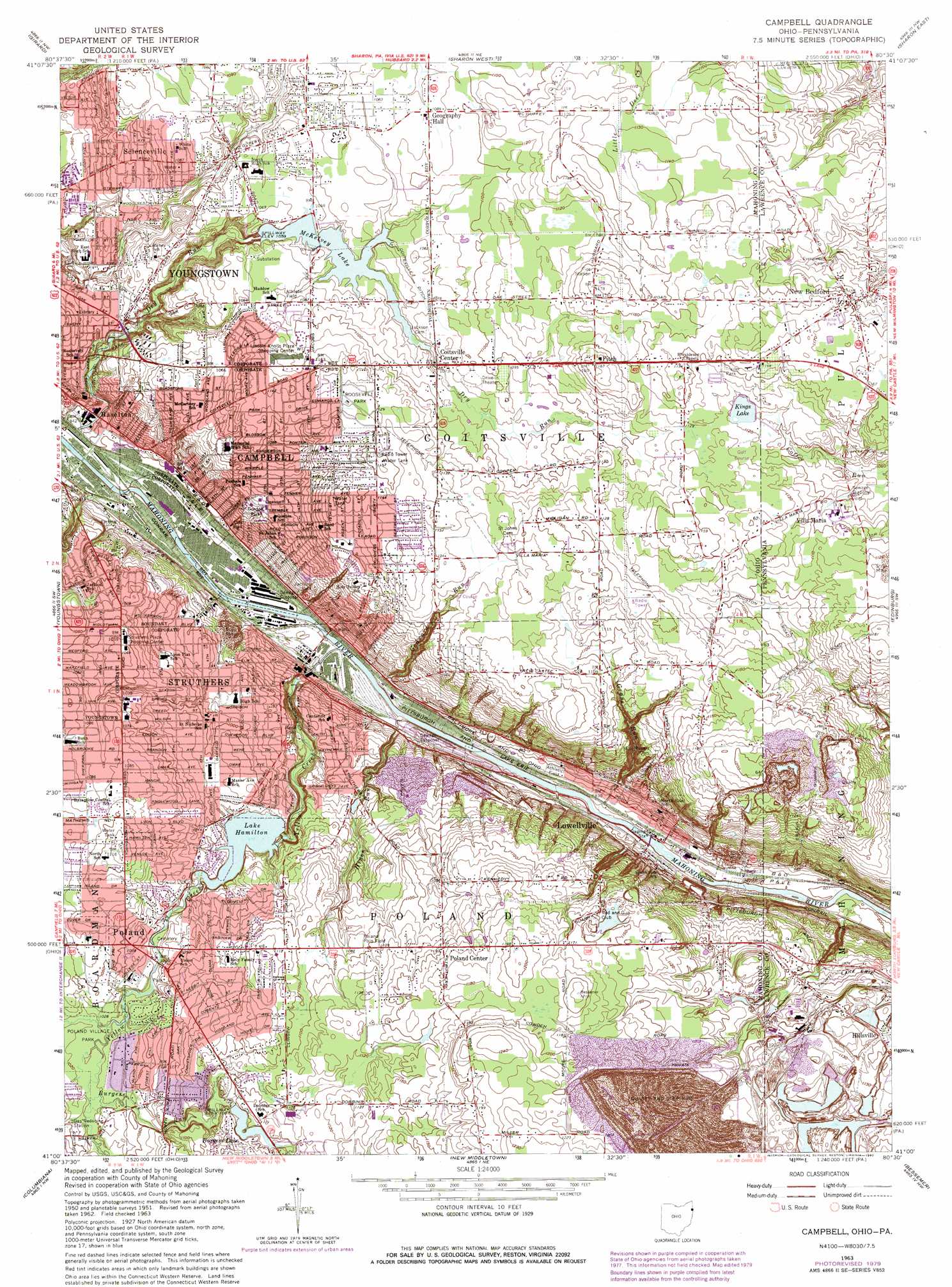
USGS Topo Quad 41080a5 - 1:24,000 scale
| Topo Map Name: | Campbell |
| USGS Topo Quad ID: | 41080a5 |
| Print Size: | ca. 21 1/4" wide x 27" high |
| Southeast Coordinates: | 41° N latitude / 80.5° W longitude |
| Map Center Coordinates: | 41.0625° N latitude / 80.5625° W longitude |
| U.S. States: | OH, PA |
| Filename: | o41080a5.jpg |
| Download Map JPG Image: | Campbell topo map 1:24,000 scale |
| Map Type: | Topographic |
| Topo Series: | 7.5´ |
| Map Scale: | 1:24,000 |
| Source of Map Images: | United States Geological Survey (USGS) |
| Alternate Map Versions: |
Campbell OH 1951, updated 1953 Download PDF Buy paper map Campbell OH 1963, updated 1964 Download PDF Buy paper map Campbell OH 1963, updated 1971 Download PDF Buy paper map Campbell OH 1963, updated 1980 Download PDF Buy paper map Campbell OH 2010 Download PDF Buy paper map Campbell OH 2013 Download PDF Buy paper map Campbell OH 2016 Download PDF Buy paper map |
1:24,000 Topo Quads surrounding Campbell
Champion |
Cortland |
Orangeville |
Sharpsville |
Fredonia |
Warren |
Girard |
Sharon West |
Sharon East |
Greenfield |
Canfield |
Youngstown |
Campbell |
Edinburg |
New Castle North |
Salem |
Columbiana |
New Middletown |
Bessemer |
New Castle South |
Lisbon |
Elkton |
East Palestine |
New Galilee |
Beaver Falls |
> Back to 41080a1 at 1:100,000 scale
> Back to 41080a1 at 1:250,000 scale
> Back to U.S. Topo Maps home
Campbell topo map: Gazetteer
Campbell: Airports
J and B Sky Ranch Airport elevation 348m 1141′Campbell: Bridges
White Bridge elevation 304m 997′Campbell: Canals
Coitsville Ditch elevation 328m 1076′Campbell: Dams
Burgess Lake Dam elevation 334m 1095′Kings Lake Dam elevation 339m 1112′
Lake Hamilton Dam elevation 284m 931′
McKelvey Lake Dam elevation 306m 1003′
Campbell: Falls
Quakertown Falls elevation 286m 938′Campbell: Lakes
Burgess Lake elevation 334m 1095′Campbell: Parks
Boehme Park elevation 293m 961′Buckeye Park elevation 314m 1030′
Fifth Street Park elevation 301m 987′
Gordon Park elevation 299m 980′
Jackson Park elevation 297m 974′
Lincoln Park elevation 280m 918′
Nebo Field elevation 290m 951′
Oak Street Extension Park elevation 329m 1079′
Poland Polo Field elevation 333m 1092′
Poland Village Park elevation 312m 1023′
Roosevelt Park elevation 343m 1125′
South Main Street Historic District elevation 315m 1033′
Victory Field elevation 293m 961′
White Park elevation 329m 1079′
Yellow Creek Park elevation 260m 853′
Campbell: Populated Places
Campbell elevation 314m 1030′Coitsville Center elevation 327m 1072′
Crab Creek Junction elevation 264m 866′
Fitch elevation 356m 1167′
Geography Hall elevation 331m 1085′
Haselton elevation 261m 856′
King's Mobile Home Park elevation 345m 1131′
Lowellville elevation 250m 820′
New Bedford elevation 349m 1145′
Newport (historical) elevation 255m 836′
Poland elevation 318m 1043′
Poland Center elevation 349m 1145′
Scienceville elevation 308m 1010′
Struthers elevation 307m 1007′
Thorn Hill elevation 326m 1069′
Villa Maria elevation 332m 1089′
Campbell: Post Offices
Coitsville Post Office (historical) elevation 329m 1079′Haselton Post Office (historical) elevation 261m 856′
Lowellville Post Office elevation 250m 820′
Poland Centre Post Office (historical) elevation 349m 1145′
Poland Post Office (historical) elevation 318m 1043′
Scienceville Post Office (historical) elevation 309m 1013′
Campbell: Reservoirs
Kings Lake elevation 339m 1112′Lake Hamilton elevation 284m 931′
McKelvey Lake elevation 306m 1003′
Campbell: Streams
Burgess Run elevation 310m 1017′Dry Run elevation 256m 839′
Godward Run elevation 252m 826′
Grays Run elevation 246m 807′
Hines Run elevation 248m 813′
Pine Hollow Creek elevation 256m 839′
Yellow Creek elevation 247m 810′
Campbell digital topo map on disk
Buy this Campbell topo map showing relief, roads, GPS coordinates and other geographical features, as a high-resolution digital map file on DVD:
 map DVD")