Youngstown Topo Map Ohio
To zoom in, hover over the map of Youngstown
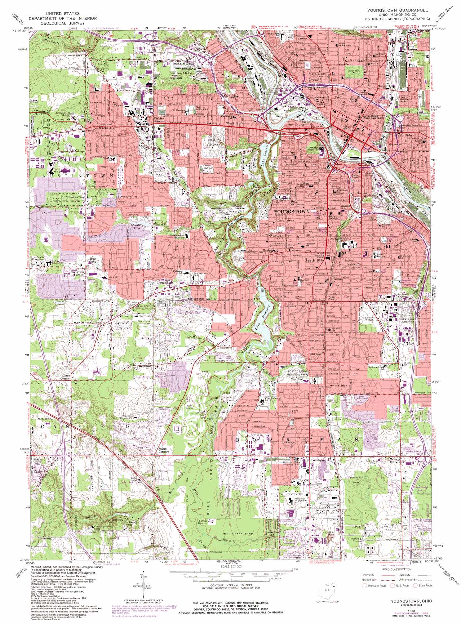
USGS Topo Quad 41080a6 - 1:24,000 scale
| Topo Map Name: | Youngstown |
| USGS Topo Quad ID: | 41080a6 |
| Print Size: | ca. 21 1/4" wide x 27" high |
| Southeast Coordinates: | 41° N latitude / 80.625° W longitude |
| Map Center Coordinates: | 41.0625° N latitude / 80.6875° W longitude |
| U.S. State: | OH |
| Filename: | o41080a6.jpg |
| Download Map JPG Image: | Youngstown topo map 1:24,000 scale |
| Map Type: | Topographic |
| Topo Series: | 7.5´ |
| Map Scale: | 1:24,000 |
| Source of Map Images: | United States Geological Survey (USGS) |
| Alternate Map Versions: |
Youngstown OH 1951, updated 1953 Download PDF Buy paper map Youngstown OH 1963, updated 1965 Download PDF Buy paper map Youngstown OH 1963, updated 1971 Download PDF Buy paper map Youngstown OH 1963, updated 1980 Download PDF Buy paper map Youngstown OH 1963, updated 1984 Download PDF Buy paper map Youngstown OH 1963, updated 1984 Download PDF Buy paper map Youngstown OH 1994, updated 1997 Download PDF Buy paper map Youngstown OH 2010 Download PDF Buy paper map Youngstown OH 2013 Download PDF Buy paper map Youngstown OH 2016 Download PDF Buy paper map |
1:24,000 Topo Quads surrounding Youngstown
Southington |
Champion |
Cortland |
Orangeville |
Sharpsville |
Newton Falls |
Warren |
Girard |
Sharon West |
Sharon East |
Lake Milton |
Canfield |
Youngstown |
Campbell |
Edinburg |
Damascus |
Salem |
Columbiana |
New Middletown |
Bessemer |
Hanoverton |
Lisbon |
Elkton |
East Palestine |
New Galilee |
> Back to 41080a1 at 1:100,000 scale
> Back to 41080a1 at 1:250,000 scale
> Back to U.S. Topo Maps home
Youngstown topo map: Gazetteer
Youngstown: Airports
Northside and Tod Childrens Hospital Heliport elevation 261m 856′Youngstown: Canals
Boardman Ditch elevation 319m 1046′Charles Ditch elevation 326m 1069′
Youngstown: Crossings
Interchange 11 elevation 322m 1056′Interchange 2 elevation 305m 1000′
Interchange 4 elevation 262m 859′
Interchange 5 elevation 277m 908′
Interchange 6 elevation 288m 944′
Interchange 7 elevation 299m 980′
Interchange 9 elevation 308m 1010′
Youngstown: Dams
Lake Cohasset Dam elevation 272m 892′Lake Glacier Dam elevation 260m 853′
Newport Lake Dam elevation 297m 974′
Rock Island Lake Dam elevation 300m 984′
Youngstown: Lakes
Lake Glacier elevation 260m 853′Lake Macachee elevation 306m 1003′
Lily Pond elevation 273m 895′
Rose Lake elevation 334m 1095′
Youngstown: Parks
Arlington Avenue Historic District elevation 287m 941′Bancroft Park elevation 330m 1082′
Boardman Park elevation 325m 1066′
Boris Field elevation 309m 1013′
Brier Hill Park elevation 292m 958′
Chicago Park elevation 321m 1053′
Crandall Park elevation 323m 1059′
Delason Park elevation 324m 1062′
Evans Field elevation 311m 1020′
Fosterville Park elevation 317m 1040′
Gibson Park elevation 283m 928′
Harrison Field elevation 261m 856′
Homestead Park elevation 320m 1049′
Idora Park elevation 318m 1043′
Kochis Park elevation 289m 948′
Kyle Park elevation 326m 1069′
Mill Creek Park elevation 300m 984′
Oak Park elevation 267m 875′
Parmelee Park elevation 320m 1049′
Pemberton Park elevation 317m 1040′
Pine Hollow Park elevation 303m 994′
Schenley Park elevation 320m 1049′
Sheridan Park elevation 326m 1069′
South Side Park elevation 286m 938′
Stambaugh Park elevation 298m 977′
Stambaugh Stadium elevation 297m 974′
Taft Park elevation 324m 1062′
Volney Rogers Field elevation 285m 935′
Wick Avenue Historic District elevation 277m 908′
Wick Park elevation 312m 1023′
Wick Park Historic District elevation 314m 1030′
Youngstown: Populated Places
Boardman elevation 339m 1112′Brier Hill elevation 317m 1040′
Central Mobile Home Park elevation 348m 1141′
Cornersburg elevation 325m 1066′
East Side elevation 264m 866′
Flint Hill elevation 333m 1092′
Fosterville elevation 323m 1059′
Fourmile Run elevation 313m 1026′
Kyles Corners elevation 328m 1076′
Lynns Corners elevation 348m 1141′
Martin Mobile Home Park elevation 338m 1108′
McKays Corners elevation 322m 1056′
North Side elevation 313m 1026′
Perkins Corners elevation 319m 1046′
South Side elevation 324m 1062′
Starrs Corners elevation 312m 1023′
West Side elevation 310m 1017′
Wickliffe elevation 330m 1082′
Williamston elevation 281m 921′
Youngstown elevation 259m 849′
Youngstown: Post Offices
Boardman Rural Station Post Office (historical) elevation 340m 1115′Brier Hill Post Office (historical) elevation 317m 1040′
Cornersburg Post Office (historical) elevation 318m 1043′
Kyles Corner Post Office (historical) elevation 328m 1076′
Youngstown Post Office elevation 259m 849′
Youngstown: Reservoirs
Lake Cohasset elevation 272m 892′Meridian Lake elevation 321m 1053′
Newport Lake elevation 297m 974′
Rock Island Lake elevation 300m 984′
Youngstown: Streams
Andersons Run elevation 300m 984′Ax Factory Run elevation 274m 898′
Bears Den Run elevation 262m 859′
Crab Creek elevation 254m 833′
Cranberry Run elevation 301m 987′
East Branch Crab Creek elevation 256m 839′
Indian Run elevation 302m 990′
Mill Creek elevation 253m 830′
Sawmill Run elevation 304m 997′
Youngstown digital topo map on disk
Buy this Youngstown topo map showing relief, roads, GPS coordinates and other geographical features, as a high-resolution digital map file on DVD:
 map DVD")