Grove City Topo Map Pennsylvania
To zoom in, hover over the map of Grove City
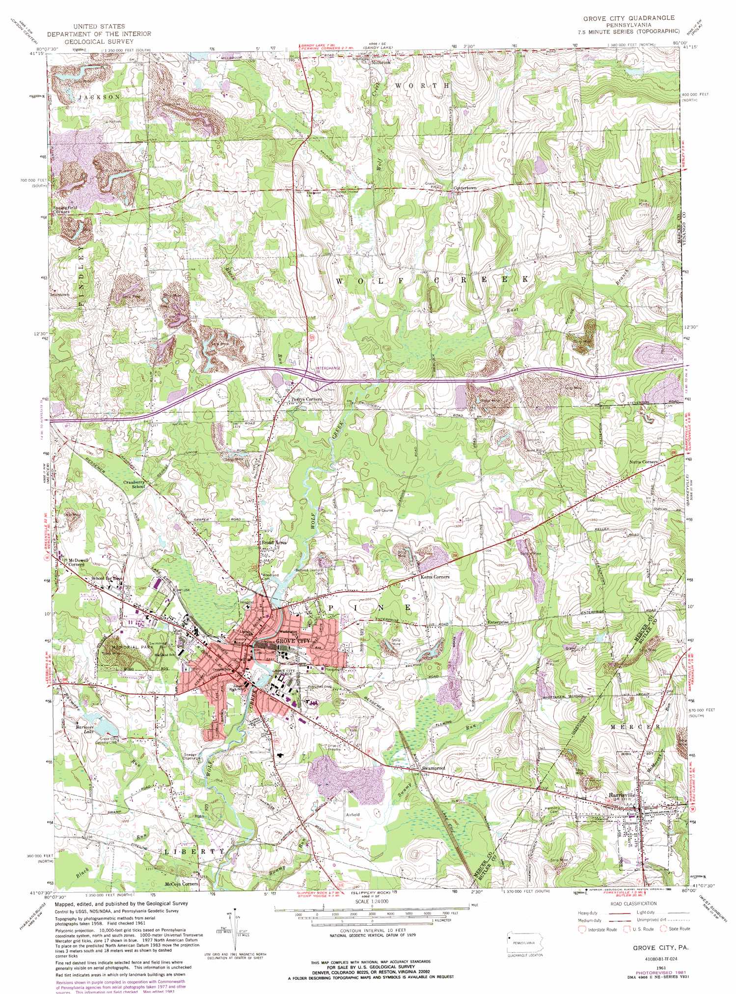
USGS Topo Quad 41080b1 - 1:24,000 scale
| Topo Map Name: | Grove City |
| USGS Topo Quad ID: | 41080b1 |
| Print Size: | ca. 21 1/4" wide x 27" high |
| Southeast Coordinates: | 41.125° N latitude / 80° W longitude |
| Map Center Coordinates: | 41.1875° N latitude / 80.0625° W longitude |
| U.S. State: | PA |
| Filename: | o41080b1.jpg |
| Download Map JPG Image: | Grove City topo map 1:24,000 scale |
| Map Type: | Topographic |
| Topo Series: | 7.5´ |
| Map Scale: | 1:24,000 |
| Source of Map Images: | United States Geological Survey (USGS) |
| Alternate Map Versions: |
Grove City PA 1961, updated 1963 Download PDF Buy paper map Grove City PA 1961, updated 1972 Download PDF Buy paper map Grove City PA 1961, updated 1982 Download PDF Buy paper map Grove City PA 1961, updated 1989 Download PDF Buy paper map Grove City PA 2010 Download PDF Buy paper map Grove City PA 2013 Download PDF Buy paper map Grove City PA 2016 Download PDF Buy paper map |
1:24,000 Topo Quads surrounding Grove City
Greenville East |
Hadley |
New Lebanon |
Utica |
Franklin |
Fredonia |
Jackson Center |
Sandy Lake |
Polk |
Kennerdell |
Greenfield |
Mercer |
Grove City |
Barkeyville |
Eau Claire |
New Castle North |
Harlansburg |
Slippery Rock |
West Sunbury |
Hilliards |
New Castle South |
Portersville |
Prospect |
Mount Chestnut |
East Butler |
> Back to 41080a1 at 1:100,000 scale
> Back to 41080a1 at 1:250,000 scale
> Back to U.S. Topo Maps home
Grove City topo map: Gazetteer
Grove City: Airports
Allison Airport elevation 403m 1322′August-Menzies-Monroe Airport elevation 383m 1256′
Flying M Ranch Airport elevation 409m 1341′
Grove City Landing Area elevation 382m 1253′
Sagulla Airport elevation 417m 1368′
Grove City: Dams
Barmore Lake Dam elevation 374m 1227′Grove City: Parks
Memorial Park elevation 386m 1266′Grove City: Populated Places
Broad Acres elevation 387m 1269′Centertown elevation 393m 1289′
Enterprise elevation 412m 1351′
Grove City elevation 387m 1269′
Harrisville elevation 400m 1312′
Irishtown elevation 372m 1220′
Kerrs Corners elevation 409m 1341′
McCoys Corners elevation 374m 1227′
McCoytown elevation 390m 1279′
Millbrook elevation 398m 1305′
Perrys Corners elevation 385m 1263′
Swamproot (historical) elevation 390m 1279′
Grove City: Reservoirs
Barmore Lake elevation 376m 1233′Grove City: Streams
Barmore Run elevation 369m 1210′Black Run elevation 366m 1200′
Black Run elevation 378m 1240′
East Branch Wolf Creek elevation 381m 1250′
Grove City digital topo map on disk
Buy this Grove City topo map showing relief, roads, GPS coordinates and other geographical features, as a high-resolution digital map file on DVD:
 map DVD")