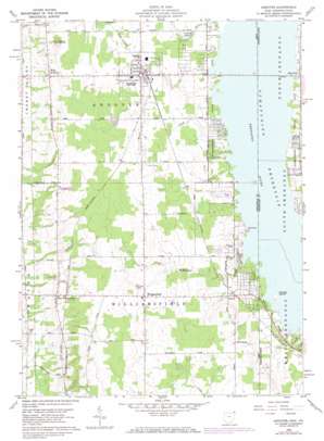
Andover Topo Map Ohio
To zoom in, hover over the map of Andover
USGS Topo Quad 41080e5 - 1:24,000 scale
| Topo Map Name: | Andover |
| USGS Topo Quad ID: | 41080e5 |
| Print Size: | ca. 21 1/4" wide x 27" high |
| Southeast Coordinates: | 41.5° N latitude / 80.5° W longitude |
| Map Center Coordinates: | 41.5625° N latitude / 80.5625° W longitude |
| U.S. States: | OH, PA |
| Filename: | o41080e5.jpg |
| Download Map JPG Image: | Andover topo map 1:24,000 scale |
| Map Type: | Topographic |
| Topo Series: | 7.5´ |
| Map Scale: | 1:24,000 |
| Source of Map Images: | United States Geological Survey (USGS) |
| Alternate Map Versions: |
Andover OH 1959, updated 1961 Download PDF Buy paper map Andover OH 1959, updated 1968 Download PDF Buy paper map Andover OH 1959, updated 1971 Download PDF Buy paper map Andover OH 1994, updated 1997 Download PDF Buy paper map Andover OH 2010 Download PDF Buy paper map Andover OH 2013 Download PDF Buy paper map Andover OH 2016 Download PDF Buy paper map |
1:24,000 Topo Quads surrounding Andover
> Back to 41080e1 at 1:100,000 scale
> Back to 41080a1 at 1:250,000 scale
> Back to U.S. Topo Maps home
Andover topo map: Gazetteer
Andover: Airports
Hal Joy Airfield elevation 351m 1151′Andover: Islands
Stocker Island elevation 308m 1010′Andover: Populated Places
Andover elevation 333m 1092′Andover Country Meadows elevation 317m 1040′
Simons elevation 324m 1062′
West Andover elevation 322m 1056′
West Williamsfield elevation 328m 1076′
Williamsfield elevation 346m 1135′
Andover: Post Offices
Andover Post Office elevation 332m 1089′West Andover Post Office (historical) elevation 320m 1049′
Williamsfield Post Office elevation 346m 1135′
Andover: Reservoirs
Crystal Lake elevation 316m 1036′Andover: Streams
Black Creek elevation 307m 1007′Gravel Run elevation 308m 1010′
McMichael Creek elevation 307m 1007′
Andover: Summits
Owens Mound elevation 363m 1190′Andover digital topo map on disk
Buy this Andover topo map showing relief, roads, GPS coordinates and other geographical features, as a high-resolution digital map file on DVD:


