Cambridge Springs Topo Map Pennsylvania
To zoom in, hover over the map of Cambridge Springs
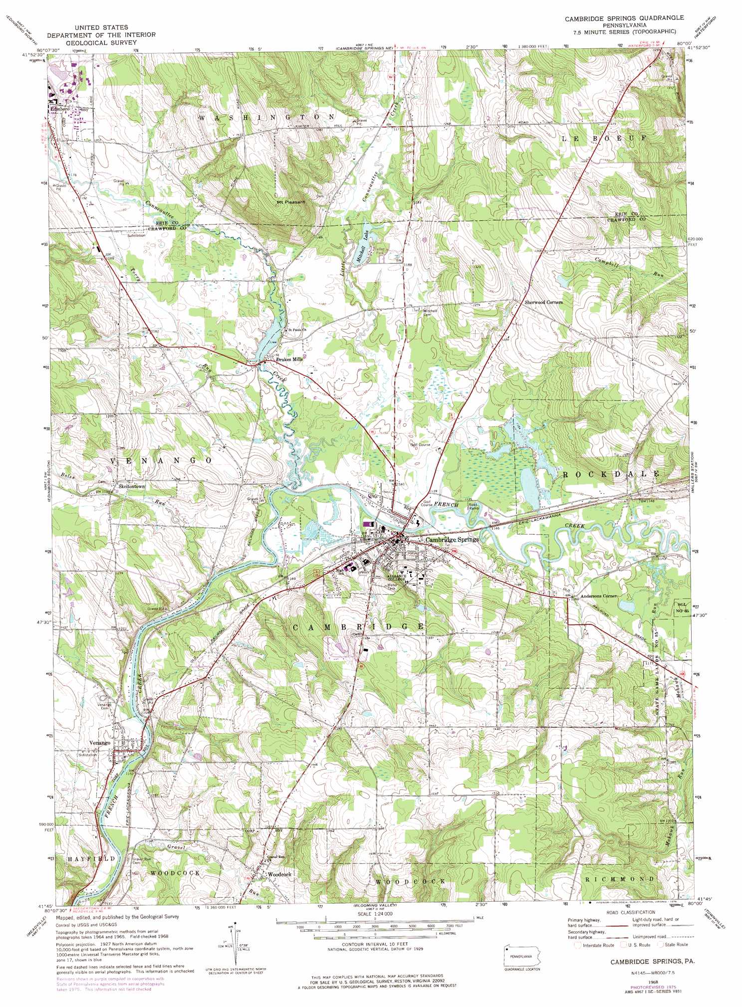
USGS Topo Quad 41080g1 - 1:24,000 scale
| Topo Map Name: | Cambridge Springs |
| USGS Topo Quad ID: | 41080g1 |
| Print Size: | ca. 21 1/4" wide x 27" high |
| Southeast Coordinates: | 41.75° N latitude / 80° W longitude |
| Map Center Coordinates: | 41.8125° N latitude / 80.0625° W longitude |
| U.S. State: | PA |
| Filename: | o41080g1.jpg |
| Download Map JPG Image: | Cambridge Springs topo map 1:24,000 scale |
| Map Type: | Topographic |
| Topo Series: | 7.5´ |
| Map Scale: | 1:24,000 |
| Source of Map Images: | United States Geological Survey (USGS) |
| Alternate Map Versions: |
Cambridge Springs PA 1968, updated 1972 Download PDF Buy paper map Cambridge Springs PA 1968, updated 1976 Download PDF Buy paper map Cambridge Springs PA 2010 Download PDF Buy paper map Cambridge Springs PA 2013 Download PDF Buy paper map Cambridge Springs PA 2016 Download PDF Buy paper map |
1:24,000 Topo Quads surrounding Cambridge Springs
Fairview |
Swanville |
Erie South |
Hammett |
Wattsburg |
Albion |
Edinboro North |
Cambridge Springs Ne |
Waterford |
Union City |
Conneautville |
Edinboro South |
Cambridge Springs |
Millers Station |
Lake Canadohta |
Harmonsburg |
Meadville |
Blooming Valley |
Townville |
Centerville |
Conneaut Lake |
Geneva |
Cochranton |
Sugar Lake |
Dempseytown |
> Back to 41080e1 at 1:100,000 scale
> Back to 41080a1 at 1:250,000 scale
> Back to U.S. Topo Maps home
Cambridge Springs topo map: Gazetteer
Cambridge Springs: Airports
Gravel Run Airport elevation 359m 1177′Rolling Acres Farm Airport elevation 364m 1194′
Cambridge Springs: Lakes
Mitchell Lake elevation 353m 1158′Cambridge Springs: Parks
State Game Lands Number 277 elevation 368m 1207′Cambridge Springs: Populated Places
Andersons Corner elevation 354m 1161′Cambridge Springs elevation 353m 1158′
Drakes Mills elevation 351m 1151′
Skeltontown elevation 366m 1200′
Venango elevation 349m 1145′
Woodcock elevation 366m 1200′
Cambridge Springs: Streams
Boles Run elevation 343m 1125′Conneauttee Creek elevation 344m 1128′
Cummings Run elevation 354m 1161′
Darrows Creek elevation 359m 1177′
Gravel Run elevation 341m 1118′
Little Conneauttee Creek elevation 344m 1128′
Mohawk Run elevation 342m 1122′
Spa Run elevation 341m 1118′
Torry Run elevation 344m 1128′
Cambridge Springs: Summits
Mount Pleasant elevation 454m 1489′Cambridge Springs digital topo map on disk
Buy this Cambridge Springs topo map showing relief, roads, GPS coordinates and other geographical features, as a high-resolution digital map file on DVD:
 map DVD")