Wadsworth Topo Map Ohio
To zoom in, hover over the map of Wadsworth
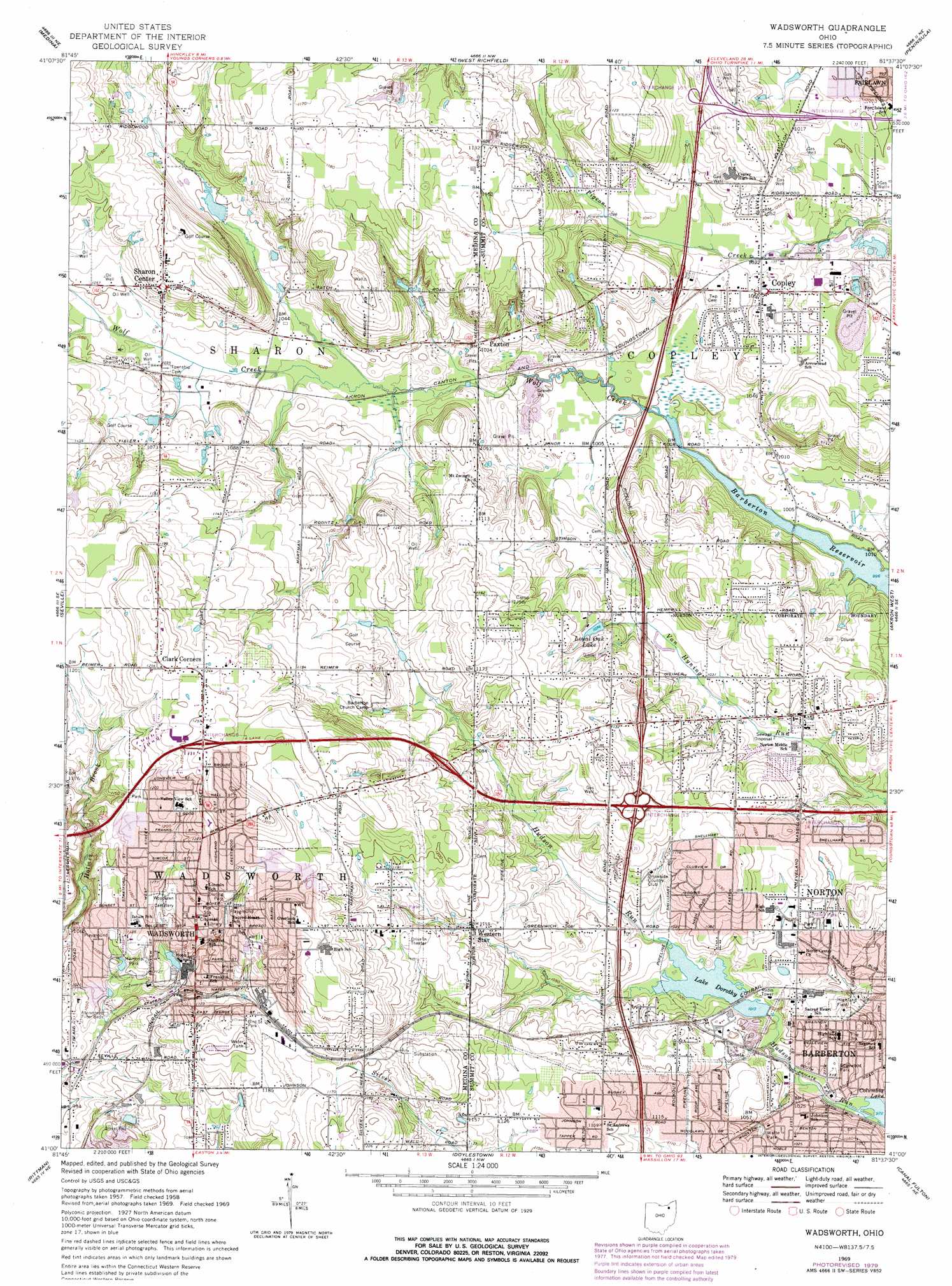
USGS Topo Quad 41081a6 - 1:24,000 scale
| Topo Map Name: | Wadsworth |
| USGS Topo Quad ID: | 41081a6 |
| Print Size: | ca. 21 1/4" wide x 27" high |
| Southeast Coordinates: | 41° N latitude / 81.625° W longitude |
| Map Center Coordinates: | 41.0625° N latitude / 81.6875° W longitude |
| U.S. State: | OH |
| Filename: | o41081a6.jpg |
| Download Map JPG Image: | Wadsworth topo map 1:24,000 scale |
| Map Type: | Topographic |
| Topo Series: | 7.5´ |
| Map Scale: | 1:24,000 |
| Source of Map Images: | United States Geological Survey (USGS) |
| Alternate Map Versions: |
Wadsworth OH 1958, updated 1959 Download PDF Buy paper map Wadsworth OH 1969, updated 1971 Download PDF Buy paper map Wadsworth OH 1969, updated 1979 Download PDF Buy paper map Wadsworth OH 1994, updated 1997 Download PDF Buy paper map Wadsworth OH 2010 Download PDF Buy paper map Wadsworth OH 2013 Download PDF Buy paper map Wadsworth OH 2016 Download PDF Buy paper map |
1:24,000 Topo Quads surrounding Wadsworth
West View |
Berea |
Broadview Heights |
Northfield |
Twinsburg |
Mallet Creek |
Medina |
West Richfield |
Peninsula |
Hudson |
Westfield Center |
Seville |
Wadsworth |
Akron West |
Akron East |
Creston |
Rittman |
Doylestown |
Canal Fulton |
North Canton |
Wooster |
Orrville |
Dalton |
Massillon |
Canton West |
> Back to 41081a1 at 1:100,000 scale
> Back to 41080a1 at 1:250,000 scale
> Back to U.S. Topo Maps home
Wadsworth topo map: Gazetteer
Wadsworth: Airports
Lehmann Airport elevation 317m 1040′Ruhlin Airport elevation 315m 1033′
Ruhlin Heliport elevation 315m 1033′
Sharondale Field elevation 359m 1177′
Wadsworth: Crossings
Interchange 13 elevation 353m 1158′Interchange 134 elevation 317m 1040′
Interchange 135 elevation 345m 1131′
Interchange 14 elevation 319m 1046′
Interchange 4 elevation 386m 1266′
Interchange 5 elevation 347m 1138′
Wadsworth: Dams
Lake Dorothy Dam elevation 299m 980′Loyal Oak Lake Dam elevation 329m 1079′
Wadsworth: Parks
Alderfer-Oenslager County Park elevation 335m 1099′Bird Street Park elevation 361m 1184′
Columbia Woods Park elevation 314m 1030′
Durling Park elevation 370m 1213′
Edgewood Park elevation 298m 977′
Greenleaf County Park elevation 313m 1026′
Holmesbrook Park elevation 332m 1089′
Memorial Park elevation 336m 1102′
Miller Field elevation 356m 1167′
Mills Road Park elevation 363m 1190′
North Woods Park elevation 380m 1246′
Sharon Center Public Square Historic District elevation 341m 1118′
Terraceview Park elevation 339m 1112′
Valley View Park elevation 361m 1184′
Wadsworth Recreation Center elevation 357m 1171′
Walte Park elevation 314m 1030′
Weatherstone Park elevation 385m 1263′
Wintergreen Park elevation 387m 1269′
Wadsworth: Populated Places
Bates Corners elevation 314m 1030′Clark Corners elevation 380m 1246′
Copley elevation 320m 1049′
Johnsons Corners elevation 312m 1023′
Norton elevation 325m 1066′
Paxton elevation 319m 1046′
Pigeon Creek elevation 317m 1040′
Sharon Center elevation 343m 1125′
Sherman (historical) elevation 330m 1082′
Sunset Mobile Home Park elevation 319m 1046′
Wadsworth elevation 356m 1167′
Wadsworth Trailer Park elevation 363m 1190′
Western Star elevation 340m 1115′
Wadsworth: Post Offices
Copley Post Office (historical) elevation 320m 1049′Paxton Post Office (historical) elevation 318m 1043′
Sharon Center Post Office elevation 336m 1102′
Sherman Post Office (historical) elevation 331m 1085′
Wadsworth Post Office elevation 358m 1174′
Wadsworth: Reservoirs
Chippewa Watershed Conservation District Structure Reservoir elevation 342m 1122′Lake Dorothy elevation 299m 980′
Loyal Oak Lake elevation 329m 1079′
Wadsworth: Streams
Hudson Run elevation 297m 974′Wadsworth digital topo map on disk
Buy this Wadsworth topo map showing relief, roads, GPS coordinates and other geographical features, as a high-resolution digital map file on DVD:
 map DVD")