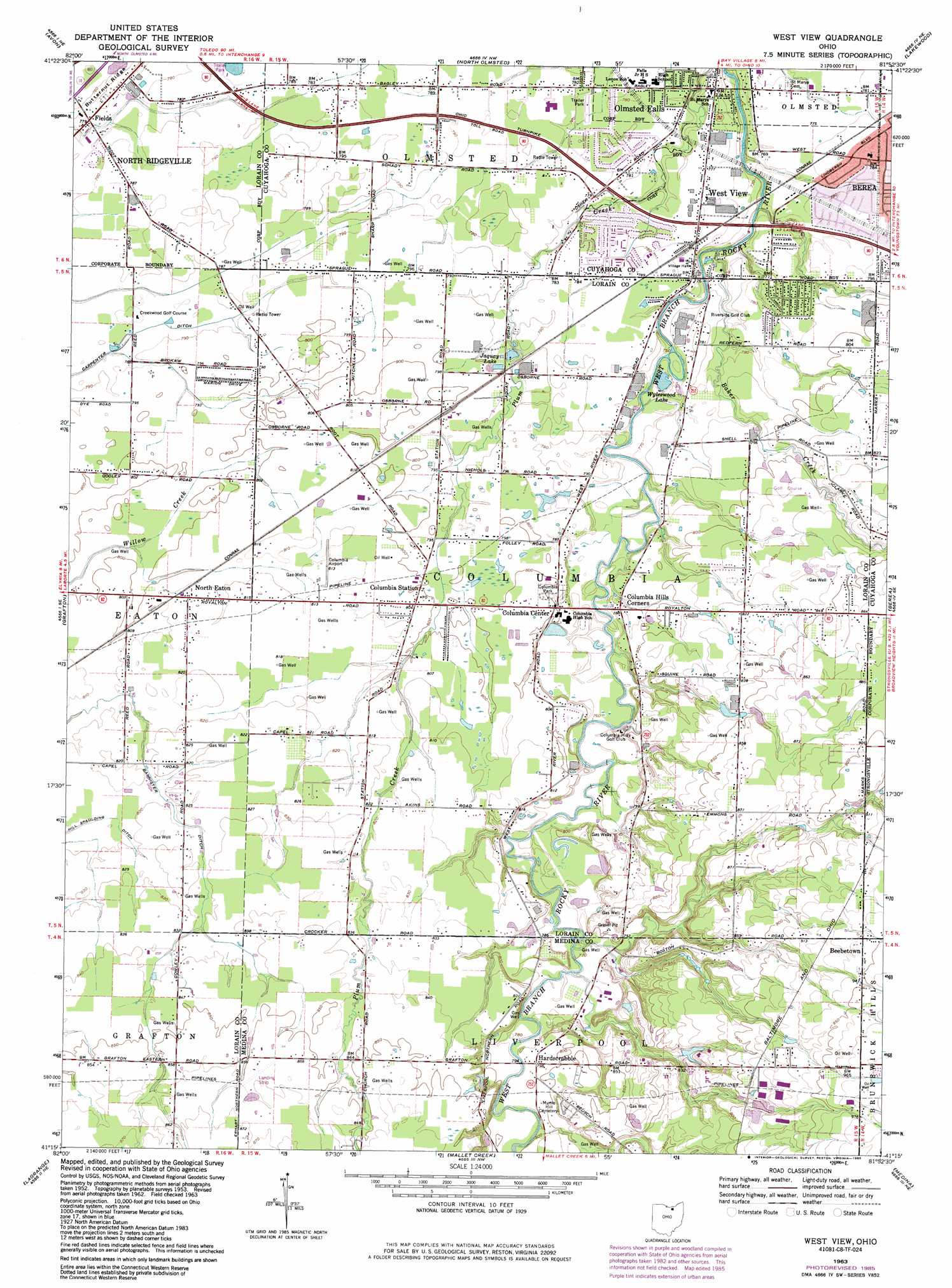
West View Topo Map Ohio
To zoom in, hover over the map of West View
USGS Topo Quad 41081c8 - 1:24,000 scale
| Topo Map Name: | West View |
| USGS Topo Quad ID: | 41081c8 |
| Print Size: | ca. 21 1/4" wide x 27" high |
| Southeast Coordinates: | 41.25° N latitude / 81.875° W longitude |
| Map Center Coordinates: | 41.3125° N latitude / 81.9375° W longitude |
| U.S. State: | OH |
| Filename: | o41081c8.jpg |
| Download Map JPG Image: | West View topo map 1:24,000 scale |
| Map Type: | Topographic |
| Topo Series: | 7.5´ |
| Map Scale: | 1:24,000 |
| Source of Map Images: | United States Geological Survey (USGS) |
| Alternate Map Versions: |
West View OH 1953, updated 1955 Download PDF Buy paper map West View OH 1963, updated 1964 Download PDF Buy paper map West View OH 1963, updated 1971 Download PDF Buy paper map West View OH 1963, updated 1985 Download PDF Buy paper map West View OH 1994, updated 1997 Download PDF Buy paper map West View OH 2010 Download PDF Buy paper map West View OH 2013 Download PDF Buy paper map West View OH 2016 Download PDF Buy paper map |
1:24,000 Topo Quads surrounding West View
Cleveland North |
||||
Lorain |
Avon |
North Olmsted |
Lakewood |
Cleveland South |
Oberlin |
Grafton |
West View |
Berea |
Broadview Heights |
Wellington |
Lagrange |
Mallet Creek |
Medina |
West Richfield |
Sullivan |
Lodi |
Westfield Center |
Seville |
Wadsworth |
> Back to 41081a1 at 1:100,000 scale
> Back to 41080a1 at 1:250,000 scale
> Back to U.S. Topo Maps home
West View topo map: Gazetteer
West View: Airports
Columbia Airport elevation 247m 810′Crocker Airport elevation 252m 826′
Gilbert Airport elevation 240m 787′
Mole Airport elevation 259m 849′
Valley City Flying Club Airport elevation 262m 859′
West View: Canals
Bannister Ditch elevation 246m 807′West View: Dams
Modern Tool and Die Company Reservoir Dam elevation 277m 908′Moll Lake Dam elevation 256m 839′
West View: Parks
Columbia Park elevation 242m 793′Root Road Athletic Complex elevation 238m 780′
West View: Populated Places
Beebetown elevation 287m 941′Columbia Center elevation 244m 800′
Columbia Hills Corners elevation 240m 787′
Columbia Station elevation 245m 803′
Fields elevation 236m 774′
Hardscrabble elevation 242m 793′
North Eaton elevation 247m 810′
Olmsted Trailer Park elevation 237m 777′
West View elevation 235m 770′
West View: Post Offices
Beebetown Post Office (historical) elevation 287m 941′Columbia Station Post Office elevation 245m 803′
Fields Post Office (historical) elevation 235m 770′
North Eaton Post Office (historical) elevation 247m 810′
Westview Post Office (historical) elevation 235m 770′
West View: Reservoirs
Jaquay Lake elevation 240m 787′Modern Tool and Die Company Reservoir elevation 277m 908′
Moll Lake elevation 256m 839′
Wyleswood Lake elevation 230m 754′
West View: Streams
Baker Creek elevation 226m 741′West View digital topo map on disk
Buy this West View topo map showing relief, roads, GPS coordinates and other geographical features, as a high-resolution digital map file on DVD:
 map DVD")