South Russell Topo Map Ohio
To zoom in, hover over the map of South Russell
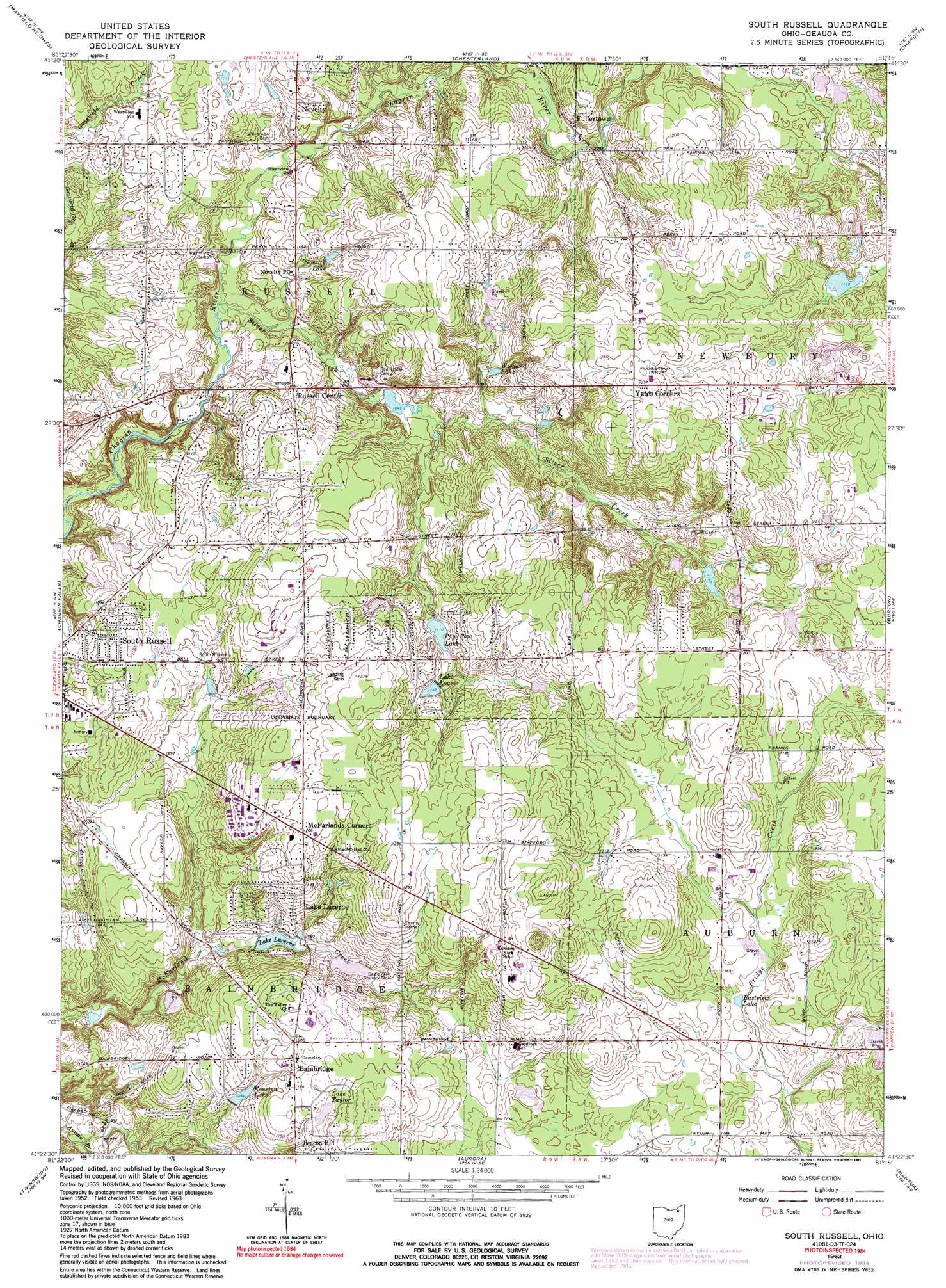
USGS Topo Quad 41081d3 - 1:24,000 scale
| Topo Map Name: | South Russell |
| USGS Topo Quad ID: | 41081d3 |
| Print Size: | ca. 21 1/4" wide x 27" high |
| Southeast Coordinates: | 41.375° N latitude / 81.25° W longitude |
| Map Center Coordinates: | 41.4375° N latitude / 81.3125° W longitude |
| U.S. State: | OH |
| Filename: | o41081d3.jpg |
| Download Map JPG Image: | South Russell topo map 1:24,000 scale |
| Map Type: | Topographic |
| Topo Series: | 7.5´ |
| Map Scale: | 1:24,000 |
| Source of Map Images: | United States Geological Survey (USGS) |
| Alternate Map Versions: |
South Russell OH 1953, updated 1954 Download PDF Buy paper map South Russell OH 1963, updated 1964 Download PDF Buy paper map South Russell OH 1963, updated 1974 Download PDF Buy paper map South Russell OH 1963, updated 1980 Download PDF Buy paper map South Russell OH 1963, updated 1984 Download PDF Buy paper map South Russell OH 1963, updated 1991 Download PDF Buy paper map South Russell OH 2010 Download PDF Buy paper map South Russell OH 2013 Download PDF Buy paper map South Russell OH 2016 Download PDF Buy paper map |
1:24,000 Topo Quads surrounding South Russell
Eastlake |
Mentor |
Painesville |
Thompson |
|
East Cleveland |
Mayfield Heights |
Chesterland |
Chardon |
East Claridon |
Shaker Heights |
Chagrin Falls |
South Russell |
Burton |
Middlefield |
Northfield |
Twinsburg |
Aurora |
Mantua |
Garrettsville |
Peninsula |
Hudson |
Kent |
Ravenna |
Windham |
> Back to 41081a1 at 1:100,000 scale
> Back to 41080a1 at 1:250,000 scale
> Back to U.S. Topo Maps home
South Russell topo map: Gazetteer
South Russell: Airports
Auburn Airport elevation 363m 1190′Chagrin Falls Airport (historical) elevation 374m 1227′
Derecsky Airport elevation 356m 1167′
Rataiczak Airport elevation 371m 1217′
South Russell: Dams
Bellwood Lake Dam elevation 344m 1128′Kenston Lake Dam elevation 333m 1092′
Lake Louise Dam elevation 348m 1141′
Lake Lucerne Dam elevation 314m 1030′
Ohnoname 15 Dam elevation 345m 1131′
Paw Paw Lake Dam elevation 338m 1108′
Tanglewood Lake Dam elevation 339m 1112′
South Russell: Lakes
Eastview Lake elevation 352m 1154′Lake Taylor elevation 356m 1167′
Novelty Lake elevation 333m 1092′
Wiegand Lake elevation 329m 1079′
South Russell: Populated Places
Bainbridge elevation 355m 1164′Beacon Hill elevation 342m 1122′
Beudale (historical) elevation 359m 1177′
Briar Hill Corners elevation 316m 1036′
Fullertown elevation 326m 1069′
Lake Lucerne elevation 354m 1161′
McFarlands Corners elevation 367m 1204′
Novelty elevation 325m 1066′
Russell Center elevation 332m 1089′
South Russell elevation 342m 1122′
Yates Corners elevation 387m 1269′
South Russell: Post Offices
Fullerton Post Office (historical) elevation 329m 1079′Novelty Post Office elevation 321m 1053′
Russell Post Office (historical) elevation 333m 1092′
South Russell: Reservoirs
Bellwood Lake elevation 344m 1128′Kenston Lake elevation 333m 1092′
Lake Louise elevation 348m 1141′
Lake Lucerne elevation 314m 1030′
Ohnoname 15 Reservoir elevation 345m 1131′
Paw Paw Lake elevation 338m 1108′
Tanglewood Lake elevation 339m 1112′
South Russell: Streams
Silver Creek elevation 305m 1000′South Russell: Summits
McConougheys Hill elevation 399m 1309′South Russell digital topo map on disk
Buy this South Russell topo map showing relief, roads, GPS coordinates and other geographical features, as a high-resolution digital map file on DVD:
 map DVD")