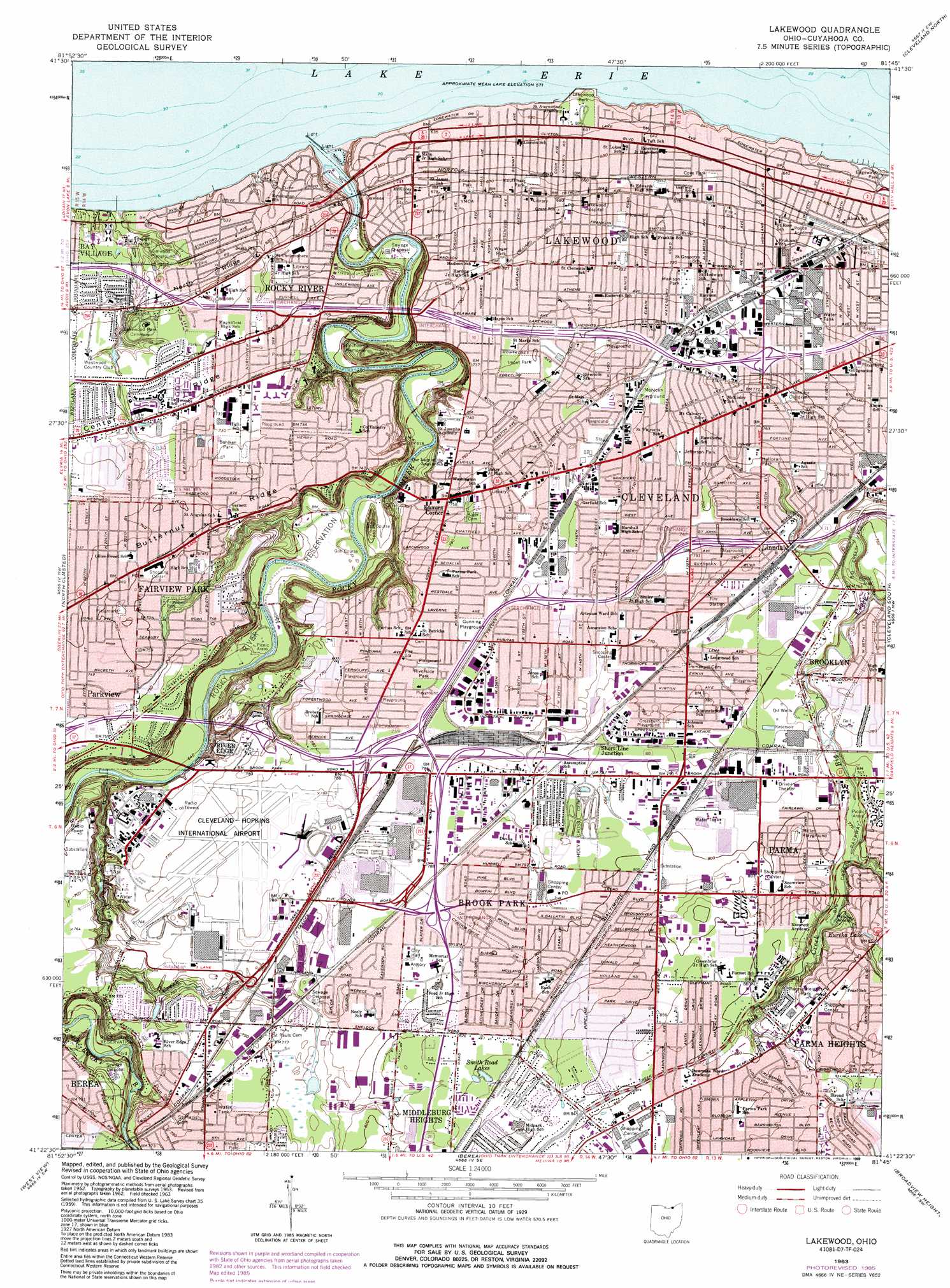
Lakewood Topo Map Ohio
To zoom in, hover over the map of Lakewood
USGS Topo Quad 41081d7 - 1:24,000 scale
| Topo Map Name: | Lakewood |
| USGS Topo Quad ID: | 41081d7 |
| Print Size: | ca. 21 1/4" wide x 27" high |
| Southeast Coordinates: | 41.375° N latitude / 81.75° W longitude |
| Map Center Coordinates: | 41.4375° N latitude / 81.8125° W longitude |
| U.S. State: | OH |
| Filename: | o41081d7.jpg |
| Download Map JPG Image: | Lakewood topo map 1:24,000 scale |
| Map Type: | Topographic |
| Topo Series: | 7.5´ |
| Map Scale: | 1:24,000 |
| Source of Map Images: | United States Geological Survey (USGS) |
| Alternate Map Versions: |
Lakewood OH 1953, updated 1955 Download PDF Buy paper map Lakewood OH 1963, updated 1964 Download PDF Buy paper map Lakewood OH 1963, updated 1971 Download PDF Buy paper map Lakewood OH 1963, updated 1985 Download PDF Buy paper map Lakewood OH 1963, updated 1989 Download PDF Buy paper map Lakewood OH 1994, updated 2000 Download PDF Buy paper map Lakewood OH 2010 Download PDF Buy paper map Lakewood OH 2013 Download PDF Buy paper map Lakewood OH 2016 Download PDF Buy paper map |
1:24,000 Topo Quads surrounding Lakewood
Cleveland North |
East Cleveland |
|||
Avon |
North Olmsted |
Lakewood |
Cleveland South |
Shaker Heights |
Grafton |
West View |
Berea |
Broadview Heights |
Northfield |
Lagrange |
Mallet Creek |
Medina |
West Richfield |
Peninsula |
> Back to 41081a1 at 1:100,000 scale
> Back to 41080a1 at 1:250,000 scale
> Back to U.S. Topo Maps home
Lakewood topo map: Gazetteer
Lakewood: Airports
1st District Police Station Heliport elevation 230m 754′Cleveland-Hopkins International Airport elevation 238m 780′
CPC Parma Heliport elevation 242m 793′
Lakewood: Beaches
Clifton Beach elevation 174m 570′Lakewood: Bridges
Detroit Avenue Bridge elevation 173m 567′Lakewood: Canals
West Channel Rocky River elevation 177m 580′Lakewood: Crossings
Interchange 10 elevation 241m 790′Interchange 11 elevation 238m 780′
Interchange 12A elevation 238m 780′
Interchange 12B elevation 240m 787′
Interchange 13 elevation 235m 770′
Interchange 161 elevation 213m 698′
Interchange 163 elevation 221m 725′
Interchange 165 elevation 228m 748′
Interchange 166 elevation 226m 741′
Interchange 167A elevation 216m 708′
Interchange 237 elevation 240m 787′
Interchange 239 elevation 241m 790′
Interchange 240 elevation 240m 787′
Lakewood: Harbors
Eddys Boat Harbor elevation 176m 577′Lakewood: Lakes
Clifton Lagoon elevation 175m 574′Eureka Lake elevation 256m 839′
Lake Abram elevation 231m 757′
Smith Road Lakes elevation 253m 830′
Lakewood: Parks
Big Creek Parkway elevation 233m 764′Big Creek Reservation elevation 215m 705′
Birdtown Historic District elevation 223m 731′
Bohlken Park elevation 223m 731′
Cleveland Lakefront State Park elevation 174m 570′
Cleveland Metroparks Ranger Department elevation 190m 623′
Clifton Park Lakefront Historic District elevation 185m 606′
Cove Park elevation 201m 659′
Crossburn Playground elevation 238m 780′
Cudell Park elevation 208m 682′
Cudell Recreation Center elevation 207m 679′
Dora Lee Payne Park elevation 238m 780′
Edwards Park elevation 206m 675′
Elmwood Playground elevation 193m 633′
Emery Park elevation 232m 761′
Fairview Park elevation 226m 741′
Gilmore Playground elevation 233m 764′
Gunning Playground elevation 240m 787′
Halloran Park elevation 229m 751′
Impet Park elevation 226m 741′
James Hanna Park elevation 248m 813′
Jefferson Park elevation 231m 757′
John Mucklo Park elevation 241m 790′
Kauffman Park elevation 204m 669′
Kurtz Park elevation 262m 859′
Lake Abram Metropolitan Reservation elevation 234m 767′
Lakewood Park elevation 193m 633′
Linden Park elevation 223m 731′
Madison Park elevation 223m 731′
Memorial Field elevation 178m 583′
Memorial Field Park elevation 218m 715′
Miller Playground elevation 252m 826′
Mohican Playground elevation 234m 767′
Puritas Springs Park (historical) elevation 229m 751′
Riverside Park elevation 241m 790′
Rocky River Reservation elevation 192m 629′
Stinchcomb Memorial elevation 207m 679′
Stroud Park elevation 268m 879′
Tri-City Park elevation 223m 731′
Tuland Playground elevation 230m 754′
Tyler Field elevation 185m 606′
Wagar Park elevation 220m 721′
Wedo Park elevation 238m 780′
Yorktown Green Park elevation 261m 856′
Lakewood: Populated Places
Birds Nest elevation 223m 731′Brook Park elevation 243m 797′
Brook Park Mobile Home Park elevation 239m 784′
Clifton Park elevation 201m 659′
Cudell elevation 213m 698′
Fairview Park elevation 228m 748′
Gresham elevation 230m 754′
Kamms Corner elevation 230m 754′
Lakewood elevation 215m 705′
Linndale elevation 231m 757′
Little Arabia elevation 234m 767′
McKinley elevation 238m 780′
North Linndale elevation 232m 761′
Parkview elevation 225m 738′
Parma Heights elevation 261m 856′
River Edge elevation 229m 751′
Rockport elevation 222m 728′
Rocky River elevation 210m 688′
Short Line Junction elevation 238m 780′
Westpark elevation 236m 774′
Lakewood: Post Offices
Clifton Park Post Office (historical) elevation 201m 659′Edgewater Branch Lakewood Post Office elevation 204m 669′
Gresham Post Office (historical) elevation 229m 751′
Lakewood Post Office elevation 211m 692′
McKinley Post Office (historical) elevation 238m 780′
North Linndale Post Office (historical) elevation 231m 757′
Rockport Post Office (historical) elevation 222m 728′
Rocky River Post Office (historical) elevation 211m 692′
West Park Post Office (historical) elevation 234m 767′
West Park Station Cleveland Post Office elevation 231m 757′
Lakewood: Streams
Abram Creek elevation 195m 639′Countrymans Creek elevation 216m 708′
Rocky River elevation 174m 570′
Stickney Creek elevation 219m 718′
Lakewood digital topo map on disk
Buy this Lakewood topo map showing relief, roads, GPS coordinates and other geographical features, as a high-resolution digital map file on DVD:
 map DVD")