Mentor Topo Map Ohio
To zoom in, hover over the map of Mentor
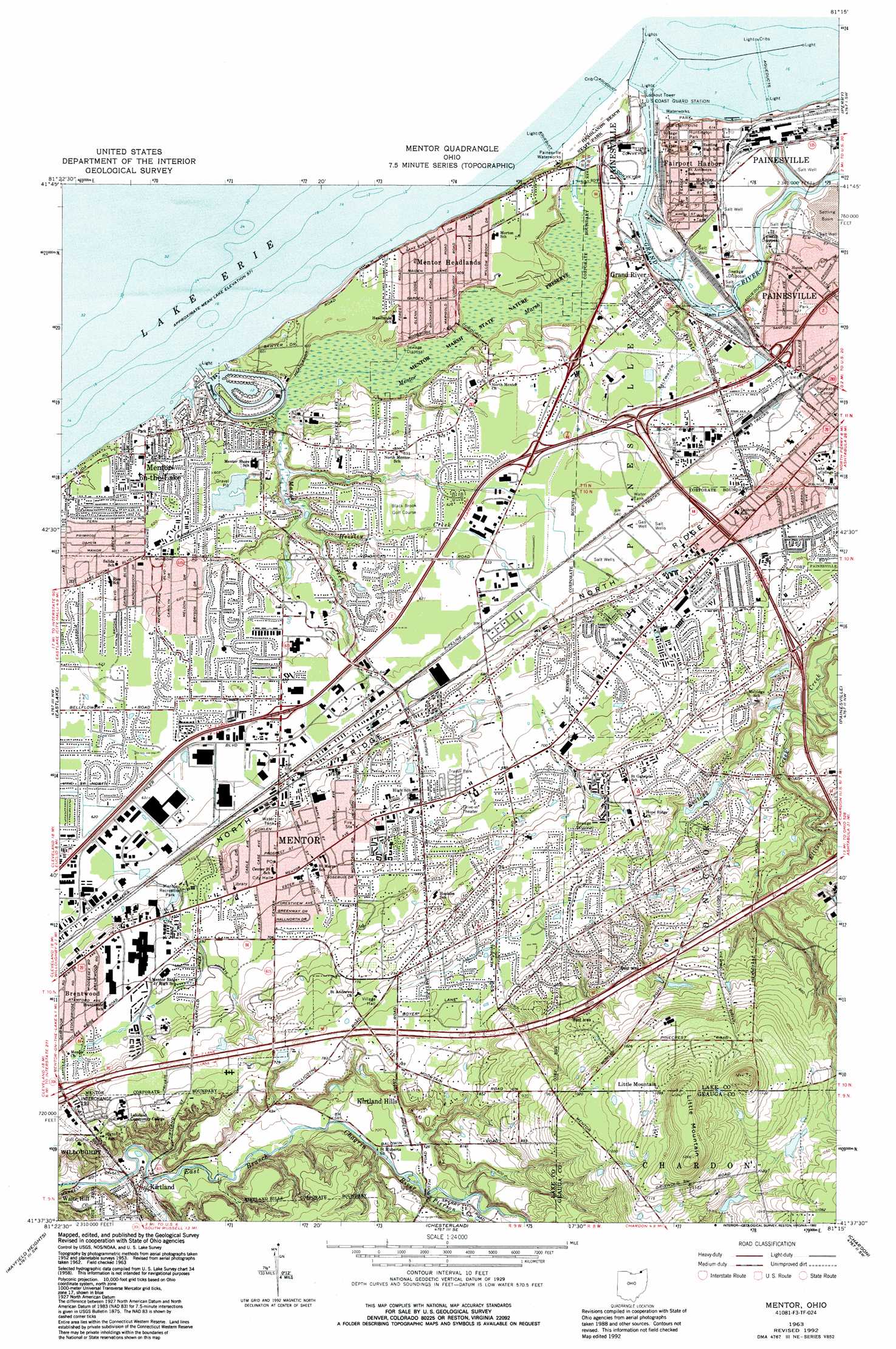
USGS Topo Quad 41081f3 - 1:24,000 scale
| Topo Map Name: | Mentor |
| USGS Topo Quad ID: | 41081f3 |
| Print Size: | ca. 21 1/4" wide x 27" high |
| Southeast Coordinates: | 41.625° N latitude / 81.25° W longitude |
| Map Center Coordinates: | 41.6875° N latitude / 81.3125° W longitude |
| U.S. State: | OH |
| Filename: | o41081f3.jpg |
| Download Map JPG Image: | Mentor topo map 1:24,000 scale |
| Map Type: | Topographic |
| Topo Series: | 7.5´ |
| Map Scale: | 1:24,000 |
| Source of Map Images: | United States Geological Survey (USGS) |
| Alternate Map Versions: |
Mentor OH 1953, updated 1955 Download PDF Buy paper map Mentor OH 1953, updated 1955 Download PDF Buy paper map Mentor OH 1963, updated 1964 Download PDF Buy paper map Mentor OH 1963, updated 1971 Download PDF Buy paper map Mentor OH 1963, updated 1979 Download PDF Buy paper map Mentor OH 1963, updated 1984 Download PDF Buy paper map Mentor OH 1963, updated 1992 Download PDF Buy paper map Mentor OH 1994, updated 2000 Download PDF Buy paper map Mentor OH 2010 Download PDF Buy paper map Mentor OH 2013 Download PDF Buy paper map Mentor OH 2016 Download PDF Buy paper map |
1:24,000 Topo Quads surrounding Mentor
Perry |
Madison |
|||
Eastlake |
Mentor |
Painesville |
Thompson |
|
East Cleveland |
Mayfield Heights |
Chesterland |
Chardon |
East Claridon |
Shaker Heights |
Chagrin Falls |
South Russell |
Burton |
Middlefield |
> Back to 41081e1 at 1:100,000 scale
> Back to 41080a1 at 1:250,000 scale
> Back to U.S. Topo Maps home
Mentor topo map: Gazetteer
Mentor: Airports
Associated Enterprises Heliport elevation 201m 659′Lake County Engineer Heliport elevation 189m 620′
Mentor: Crossings
Interchange 193 elevation 222m 728′Interchange 193 elevation 228m 748′
Mentor: Harbors
Mentor Harbor elevation 177m 580′Mentor: Islands
Ram Island elevation 174m 570′Mentor: Parks
Chillicothe Park elevation 231m 757′James A Garfield National Historic Site elevation 209m 685′
Jerome T Osborne Senior Stadium elevation 191m 626′
Mentor Beach Park elevation 180m 590′
Mentor Marsh State Nature Preserve elevation 174m 570′
Mentor Recreation Park elevation 204m 669′
Ohio Street Park elevation 192m 629′
Veterans Memorial Park elevation 187m 613′
Wildwood Park elevation 221m 725′
Mentor: Populated Places
Avenues Mobile Estates elevation 207m 679′Brentwood elevation 214m 702′
Driftwood elevation 185m 606′
Fairgrounds Mobile Home Park elevation 205m 672′
Grand River elevation 186m 610′
Hach's Mobile Home Park elevation 210m 688′
Heisley (historical) elevation 196m 643′
Kirtland elevation 202m 662′
Little Mountain elevation 327m 1072′
Mentor elevation 211m 692′
Mentor Acres elevation 192m 629′
Mentor Headlands elevation 186m 610′
Mentor-on-the-Lake elevation 189m 620′
Mountain View elevation 191m 626′
Orchard Grove elevation 206m 675′
Salida elevation 189m 620′
Salida Beach elevation 187m 613′
West Mentor elevation 213m 698′
West Walnut Estates elevation 206m 675′
Mentor: Post Offices
Grand River Post Office elevation 186m 610′Little Mountain Post Office (historical) elevation 327m 1072′
Mentor Post Office elevation 210m 688′
Mentor-on-the-Lake Post Office (historical) elevation 189m 620′
Salida Post Office (historical) elevation 189m 620′
West Mentor Post Office (historical) elevation 213m 698′
Mentor: Reservoirs
L'Alouette Plumee Lake elevation 216m 708′Sans Souce Lake elevation 215m 705′
Mentor: Streams
Ellison Creek elevation 210m 688′Heisley Creek elevation 178m 583′
Marsh Creek elevation 176m 577′
Pebble Branch elevation 176m 577′
Pierson Creek elevation 219m 718′
Mentor: Summits
Kirtland Hills elevation 241m 790′Little Mountain elevation 374m 1227′
The Knob elevation 378m 1240′
Mentor: Swamps
Mentor Marsh elevation 175m 574′Mentor digital topo map on disk
Buy this Mentor topo map showing relief, roads, GPS coordinates and other geographical features, as a high-resolution digital map file on DVD:
 map DVD")