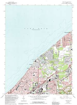
Eastlake Topo Map Ohio
To zoom in, hover over the map of Eastlake
USGS Topo Quad 41081f4 - 1:24,000 scale
| Topo Map Name: | Eastlake |
| USGS Topo Quad ID: | 41081f4 |
| Print Size: | ca. 21 1/4" wide x 27" high |
| Southeast Coordinates: | 41.625° N latitude / 81.375° W longitude |
| Map Center Coordinates: | 41.6875° N latitude / 81.4375° W longitude |
| U.S. State: | OH |
| Filename: | o41081f4.jpg |
| Download Map JPG Image: | Eastlake topo map 1:24,000 scale |
| Map Type: | Topographic |
| Topo Series: | 7.5´ |
| Map Scale: | 1:24,000 |
| Source of Map Images: | United States Geological Survey (USGS) |
| Alternate Map Versions: |
Eastlake OH 1953, updated 1955 Download PDF Buy paper map Eastlake OH 1963, updated 1965 Download PDF Buy paper map Eastlake OH 1963, updated 1971 Download PDF Buy paper map Eastlake OH 1963, updated 1979 Download PDF Buy paper map Eastlake OH 1963, updated 1992 Download PDF Buy paper map Eastlake OH 1994, updated 1997 Download PDF Buy paper map Eastlake OH 2010 Download PDF Buy paper map Eastlake OH 2013 Download PDF Buy paper map Eastlake OH 2016 Download PDF Buy paper map |
1:24,000 Topo Quads surrounding Eastlake
Perry |
||||
Eastlake |
Mentor |
Painesville |
||
Cleveland North |
East Cleveland |
Mayfield Heights |
Chesterland |
Chardon |
Cleveland South |
Shaker Heights |
Chagrin Falls |
South Russell |
Burton |
> Back to 41081e1 at 1:100,000 scale
> Back to 41080a1 at 1:250,000 scale
> Back to U.S. Topo Maps home
Eastlake topo map: Gazetteer
Eastlake: Airports
Lost Nation Airport elevation 189m 620′Eastlake: Bridges
Airborne Memorial Bridge elevation 181m 593′Eastlake: Capes
Elk Point elevation 184m 603′Eastlake: Parks
Bellflower Park elevation 189m 620′Chagrin River Park elevation 181m 593′
Classic Park elevation 191m 626′
Daniels Park elevation 186m 610′
Dudley Park elevation 189m 620′
Gilson Park elevation 181m 593′
Manry Park elevation 192m 629′
Overlook Beach Park elevation 181m 593′
Retention Basin Park elevation 188m 616′
Saint Clair Park elevation 192m 629′
Todd Field elevation 182m 597′
Wes Point Park elevation 204m 669′
Willoughby Municipal Park elevation 187m 613′
Eastlake: Populated Places
Arrowhead Beach elevation 190m 623′Brookwood Beach elevation 184m 603′
Chagrin Harbor elevation 186m 610′
Chargin Harbor Beach elevation 175m 574′
Eastlake elevation 189m 620′
Erie Side elevation 189m 620′
Lakeline elevation 189m 620′
M And K Trailer Park elevation 185m 606′
Mentor Green Mobile Home Park elevation 210m 688′
Oak Hill Village elevation 192m 629′
Orchard Mobile Home Park elevation 200m 656′
Reynolds elevation 199m 652′
Timberlake elevation 189m 620′
Vinewood Beach elevation 187m 613′
Will-O-Bee on the Lake elevation 189m 620′
Willoughbeach elevation 187m 613′
Willoughby elevation 201m 659′
Will-O-Way Beach elevation 188m 616′
Willowick elevation 189m 620′
Will-O-Wick elevation 189m 620′
Eastlake: Post Offices
Chagrin Harbor Rural Station Post Office (historical) elevation 176m 577′Erieside Post Office (historical) elevation 189m 620′
Willoughby Post Office elevation 201m 659′
Willoughby Post Office elevation 198m 649′
Eastlake: Streams
Chagrin River elevation 174m 570′East Branch Chagrin River elevation 184m 603′
Ward Brook elevation 176m 577′
Eastlake: Summits
Waite Hill elevation 196m 643′Eastlake digital topo map on disk
Buy this Eastlake topo map showing relief, roads, GPS coordinates and other geographical features, as a high-resolution digital map file on DVD:


