Wellington Topo Map Ohio
To zoom in, hover over the map of Wellington
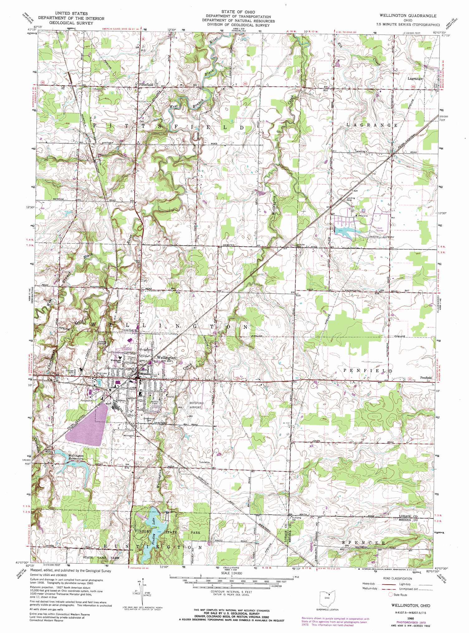
USGS Topo Quad 41082b2 - 1:24,000 scale
| Topo Map Name: | Wellington |
| USGS Topo Quad ID: | 41082b2 |
| Print Size: | ca. 21 1/4" wide x 27" high |
| Southeast Coordinates: | 41.125° N latitude / 82.125° W longitude |
| Map Center Coordinates: | 41.1875° N latitude / 82.1875° W longitude |
| U.S. State: | OH |
| Filename: | o41082b2.jpg |
| Download Map JPG Image: | Wellington topo map 1:24,000 scale |
| Map Type: | Topographic |
| Topo Series: | 7.5´ |
| Map Scale: | 1:24,000 |
| Source of Map Images: | United States Geological Survey (USGS) |
| Alternate Map Versions: |
Wellington OH 1960, updated 1961 Download PDF Buy paper map Wellington OH 1960, updated 1972 Download PDF Buy paper map Wellington OH 1960, updated 1974 Download PDF Buy paper map Wellington OH 2010 Download PDF Buy paper map Wellington OH 2013 Download PDF Buy paper map Wellington OH 2016 Download PDF Buy paper map |
1:24,000 Topo Quads surrounding Wellington
Vermilion West |
Vermilion East |
Lorain |
Avon |
North Olmsted |
Berlin Heights |
Kipton |
Oberlin |
Grafton |
West View |
Clarksfield |
Brighton |
Wellington |
Lagrange |
Mallet Creek |
New London |
Nova |
Sullivan |
Lodi |
Westfield Center |
Olivesburg |
Ashland North |
Polk |
West Salem |
Creston |
> Back to 41082a1 at 1:100,000 scale
> Back to 41082a1 at 1:250,000 scale
> Back to U.S. Topo Maps home
Wellington topo map: Gazetteer
Wellington: Airports
Botsford Airport elevation 261m 856′Pheasant Run Airport elevation 251m 823′
Wellington Community Hospital Heliport elevation 259m 849′
Wellington: Dams
Findley Lake Dam elevation 262m 859′Ponderosa Pines Lake Dam elevation 252m 826′
Wellington Reservoir Number Two Dam elevation 265m 869′
Wellington Upground Reservoir Dam elevation 267m 875′
Wellington: Parks
Findley State Park elevation 278m 912′Wellington Center Historic District elevation 260m 853′
Wellington Historic District elevation 260m 853′
West Lake Park elevation 258m 846′
Wellington: Populated Places
Brookside Mobile Home Park elevation 248m 813′Pheasant Run Village elevation 253m 830′
Pittsfield elevation 249m 816′
Smith's Mobile Home Park elevation 251m 823′
Wellington elevation 259m 849′
Wellington Mobile Home Park elevation 257m 843′
Wellington: Post Offices
Pittsfield Post Office (historical) elevation 249m 816′Wellington Post Office elevation 260m 853′
Wellington: Reservoirs
Findley Lake elevation 262m 859′Ponderosa Pines Lake elevation 252m 826′
Wellington Reservoir Number Two elevation 265m 869′
Wellington Reservoirs elevation 257m 843′
Wellington Upground Reservoir elevation 267m 875′
Wellington: Streams
Charlemont Creek elevation 240m 787′Wellington digital topo map on disk
Buy this Wellington topo map showing relief, roads, GPS coordinates and other geographical features, as a high-resolution digital map file on DVD:
 map DVD")