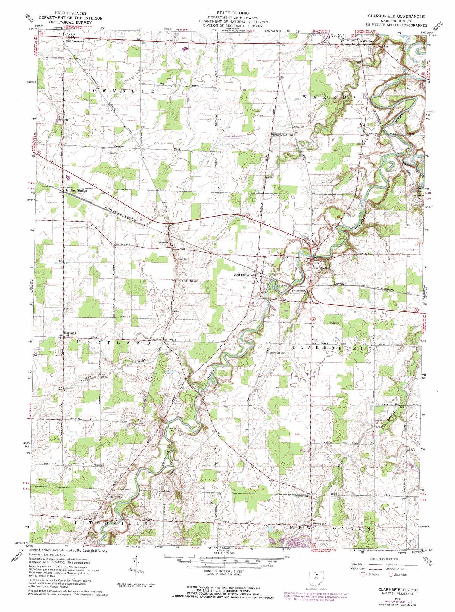
Clarksfield Topo Map Ohio
To zoom in, hover over the map of Clarksfield
USGS Topo Quad 41082b4 - 1:24,000 scale
| Topo Map Name: | Clarksfield |
| USGS Topo Quad ID: | 41082b4 |
| Print Size: | ca. 21 1/4" wide x 27" high |
| Southeast Coordinates: | 41.125° N latitude / 82.375° W longitude |
| Map Center Coordinates: | 41.1875° N latitude / 82.4375° W longitude |
| U.S. State: | OH |
| Filename: | o41082b4.jpg |
| Download Map JPG Image: | Clarksfield topo map 1:24,000 scale |
| Map Type: | Topographic |
| Topo Series: | 7.5´ |
| Map Scale: | 1:24,000 |
| Source of Map Images: | United States Geological Survey (USGS) |
| Alternate Map Versions: |
Clarksfield OH 1960, updated 1962 Download PDF Buy paper map Clarksfield OH 1960, updated 1973 Download PDF Buy paper map Clarksfield OH 2010 Download PDF Buy paper map Clarksfield OH 2013 Download PDF Buy paper map Clarksfield OH 2016 Download PDF Buy paper map |
1:24,000 Topo Quads surrounding Clarksfield
Sandusky |
Huron |
Vermilion West |
Vermilion East |
Lorain |
Kimball |
Milan |
Berlin Heights |
Kipton |
Oberlin |
Monroeville |
Norwalk |
Clarksfield |
Brighton |
Wellington |
Willard |
Greenwich |
New London |
Nova |
Sullivan |
Shelby |
Shiloh |
Olivesburg |
Ashland North |
Polk |
> Back to 41082a1 at 1:100,000 scale
> Back to 41082a1 at 1:250,000 scale
> Back to U.S. Topo Maps home
Clarksfield topo map: Gazetteer
Clarksfield: Airports
D A Chandler Airport elevation 292m 958′Clarksfield: Dams
Ockenga Pond Dam elevation 258m 846′White Pond Dam elevation 284m 931′
Clarksfield: Populated Places
Clarksfield elevation 263m 862′East Townsend elevation 274m 898′
Hartland elevation 287m 941′
Hartland Station elevation 286m 938′
West Clarksfield elevation 277m 908′
Clarksfield: Post Offices
Clarksfield Post Office (historical) elevation 270m 885′East Townsend Post Office (historical) elevation 274m 898′
Hartland Post Office (historical) elevation 286m 938′
West Clarksfield Post Office (historical) elevation 277m 908′
Clarksfield: Reservoirs
Ockenga Pond elevation 258m 846′White Pond elevation 284m 931′
Clarksfield: Streams
East Branch Vermilion River elevation 251m 823′Indian Creek elevation 273m 895′
Clarksfield digital topo map on disk
Buy this Clarksfield topo map showing relief, roads, GPS coordinates and other geographical features, as a high-resolution digital map file on DVD:
 map DVD")