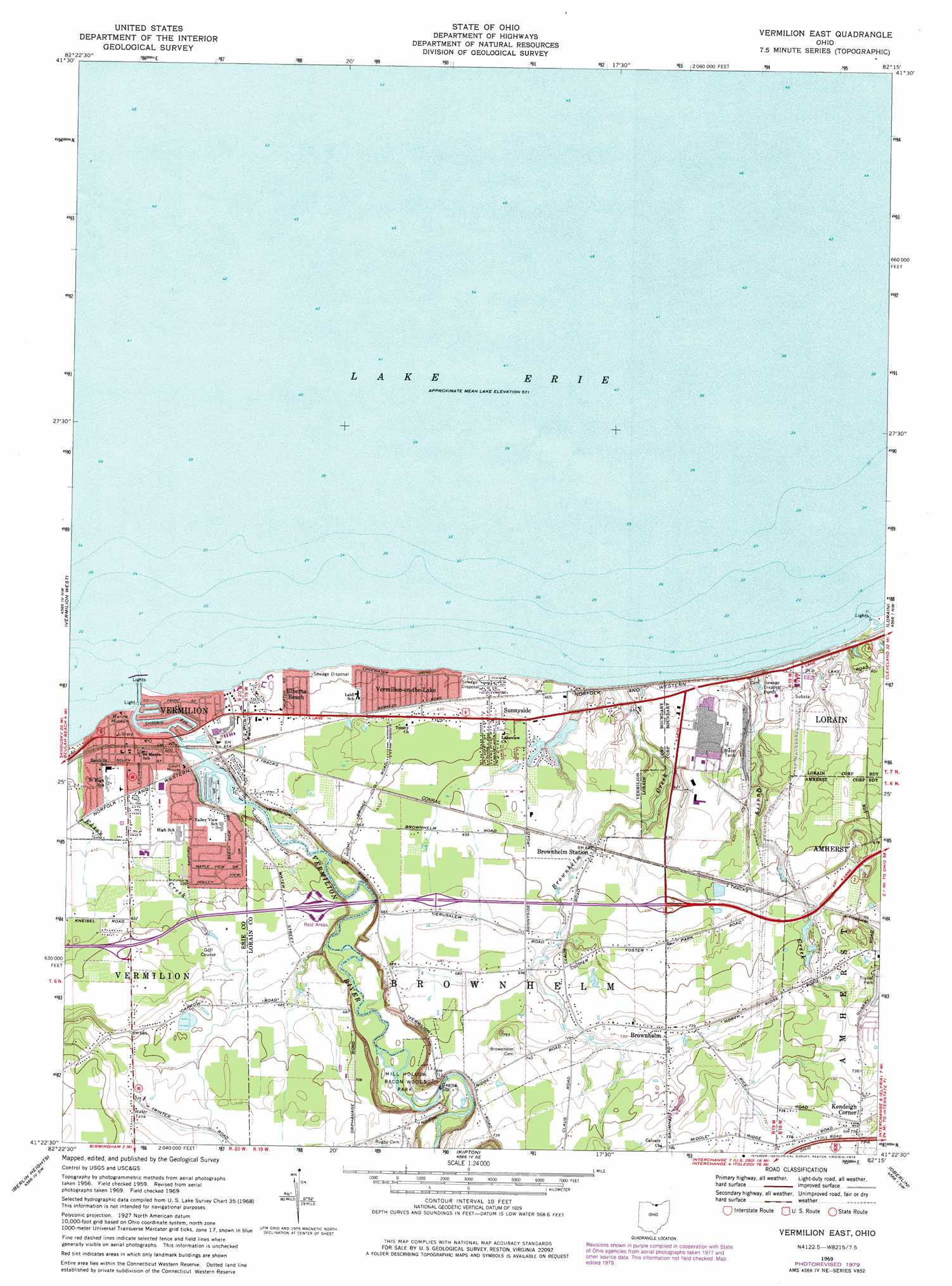
Vermilion East Topo Map Ohio
To zoom in, hover over the map of Vermilion East
USGS Topo Quad 41082d3 - 1:24,000 scale
| Topo Map Name: | Vermilion East |
| USGS Topo Quad ID: | 41082d3 |
| Print Size: | ca. 21 1/4" wide x 27" high |
| Southeast Coordinates: | 41.375° N latitude / 82.25° W longitude |
| Map Center Coordinates: | 41.4375° N latitude / 82.3125° W longitude |
| U.S. State: | OH |
| Filename: | o41082d3.jpg |
| Download Map JPG Image: | Vermilion East topo map 1:24,000 scale |
| Map Type: | Topographic |
| Topo Series: | 7.5´ |
| Map Scale: | 1:24,000 |
| Source of Map Images: | United States Geological Survey (USGS) |
| Alternate Map Versions: |
Vermilion East OH 1959, updated 1960 Download PDF Buy paper map Vermilion East OH 1959, updated 1968 Download PDF Buy paper map Vermilion East OH 1969, updated 1971 Download PDF Buy paper map Vermilion East OH 1969, updated 1979 Download PDF Buy paper map Vermilion East OH 1969, updated 1979 Download PDF Buy paper map Vermilion East OH 2010 Download PDF Buy paper map Vermilion East OH 2013 Download PDF Buy paper map Vermilion East OH 2016 Download PDF Buy paper map |
1:24,000 Topo Quads surrounding Vermilion East
Huron |
Vermilion West |
Vermilion East |
Lorain |
Avon |
Milan |
Berlin Heights |
Kipton |
Oberlin |
Grafton |
Norwalk |
Clarksfield |
Brighton |
Wellington |
Lagrange |
> Back to 41082a1 at 1:100,000 scale
> Back to 41082a1 at 1:250,000 scale
> Back to U.S. Topo Maps home
Vermilion East topo map: Gazetteer
Vermilion East: Beaches
Main Street Beach elevation 176m 577′Vermilion East: Dams
Lake Haven Estates Dam elevation 185m 606′Vermilion East: Lakes
Erie Lagoon elevation 176m 577′Huron Lagoon elevation 176m 577′
Ontario Lagoon elevation 176m 577′
Superior Lagoon elevation 175m 574′
Vermilion East: Parks
Brownhelm Historic District elevation 223m 731′Linwood Park elevation 180m 590′
Mill Hollow Bacon Woods Park elevation 211m 692′
Showse Park elevation 183m 600′
Vermilion East: Populated Places
Brownhelm elevation 223m 731′Brownhelm Station elevation 195m 639′
Elberta Beach elevation 182m 597′
Kendeigh Corner elevation 236m 774′
Rugby (historical) elevation 207m 679′
Sunnyside elevation 197m 646′
Vermilion elevation 181m 593′
Vermilion-on-the-Lake elevation 185m 606′
Vermilion East: Post Offices
Brownhelm Post Office (historical) elevation 223m 731′Brownhelm Station Post Office (historical) elevation 193m 633′
Rugby Post Office (historical) elevation 205m 672′
Vermilion Post Office elevation 180m 590′
Vermilion East: Reservoirs
Lake Haven Estates Reservoir elevation 185m 606′Vermilion East: Streams
Beaver Creek elevation 175m 574′Brownhelm Creek elevation 179m 587′
Edson Creek elevation 176m 577′
Quarry Creek elevation 175m 574′
Vermilion River elevation 174m 570′
Vermilion East digital topo map on disk
Buy this Vermilion East topo map showing relief, roads, GPS coordinates and other geographical features, as a high-resolution digital map file on DVD:
 map DVD")