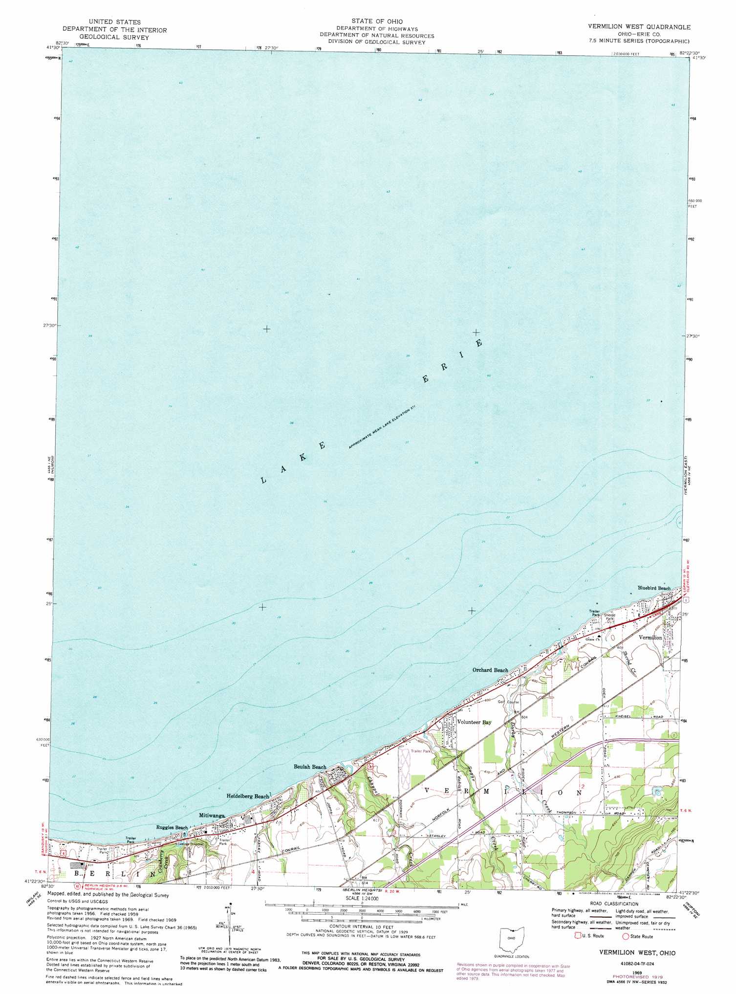
Vermilion West Topo Map Ohio
To zoom in, hover over the map of Vermilion West
USGS Topo Quad 41082d4 - 1:24,000 scale
| Topo Map Name: | Vermilion West |
| USGS Topo Quad ID: | 41082d4 |
| Print Size: | ca. 21 1/4" wide x 27" high |
| Southeast Coordinates: | 41.375° N latitude / 82.375° W longitude |
| Map Center Coordinates: | 41.4375° N latitude / 82.4375° W longitude |
| U.S. State: | OH |
| Filename: | o41082d4.jpg |
| Download Map JPG Image: | Vermilion West topo map 1:24,000 scale |
| Map Type: | Topographic |
| Topo Series: | 7.5´ |
| Map Scale: | 1:24,000 |
| Source of Map Images: | United States Geological Survey (USGS) |
| Alternate Map Versions: |
Vermilion West OH 1959, updated 1960 Download PDF Buy paper map Vermilion West OH 1969, updated 1971 Download PDF Buy paper map Vermilion West OH 1969, updated 1988 Download PDF Buy paper map Vermilion West OH 2010 Download PDF Buy paper map Vermilion West OH 2013 Download PDF Buy paper map Vermilion West OH 2016 Download PDF Buy paper map |
1:24,000 Topo Quads surrounding Vermilion West
Kelleys Island |
||||
Sandusky |
Huron |
Vermilion West |
Vermilion East |
Lorain |
Kimball |
Milan |
Berlin Heights |
Kipton |
Oberlin |
Monroeville |
Norwalk |
Clarksfield |
Brighton |
Wellington |
> Back to 41082a1 at 1:100,000 scale
> Back to 41082a1 at 1:250,000 scale
> Back to U.S. Topo Maps home
Vermilion West topo map: Gazetteer
Vermilion West: Airports
Waterwood Heliport elevation 182m 597′Vermilion West: Parks
Sherod Park elevation 179m 587′Vermilion West: Populated Places
Ashmont (historical) elevation 189m 620′Beulah Beach elevation 184m 603′
Bluebird Beach elevation 183m 600′
Colonial Villa elevation 185m 606′
Darby Place Mobile Home Park elevation 179m 587′
Harbourtown Mobile Home Community elevation 184m 603′
Heidelberg Beach elevation 184m 603′
Mitiwanga elevation 183m 600′
Orchard Beach elevation 179m 587′
Portland Court elevation 176m 577′
Ruggles Beach elevation 180m 590′
Vacationland Mobile Home Park elevation 186m 610′
Volunteer Bay elevation 184m 603′
Vermilion West: Post Offices
Ashmont Post Office (historical) elevation 189m 620′Beulah Beach Post Office (historical) elevation 183m 600′
Mitiwanga Post Office (historical) elevation 177m 580′
Vermilion West: Streams
Chappel Creek elevation 175m 574′Cranberry Creek elevation 176m 577′
Darby Creek elevation 175m 574′
Sherod Creek elevation 175m 574′
Sugar Creek elevation 176m 577′
Vermilion West digital topo map on disk
Buy this Vermilion West topo map showing relief, roads, GPS coordinates and other geographical features, as a high-resolution digital map file on DVD:
 map DVD")