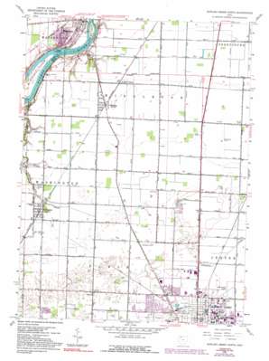
Bowling Green North Topo Map Ohio
To zoom in, hover over the map of Bowling Green North
USGS Topo Quad 41083d6 - 1:24,000 scale
| Topo Map Name: | Bowling Green North |
| USGS Topo Quad ID: | 41083d6 |
| Print Size: | ca. 21 1/4" wide x 27" high |
| Southeast Coordinates: | 41.375° N latitude / 83.625° W longitude |
| Map Center Coordinates: | 41.4375° N latitude / 83.6875° W longitude |
| U.S. State: | OH |
| Filename: | o41083d6.jpg |
| Download Map JPG Image: | Bowling Green North topo map 1:24,000 scale |
| Map Type: | Topographic |
| Topo Series: | 7.5´ |
| Map Scale: | 1:24,000 |
| Source of Map Images: | United States Geological Survey (USGS) |
| Alternate Map Versions: |
Tontogany OH 1952, updated 1953 Download PDF Buy paper map Bowling Green North OH 1958, updated 1960 Download PDF Buy paper map Bowling Green North OH 1958, updated 1972 Download PDF Buy paper map Bowling Green North OH 1958, updated 1976 Download PDF Buy paper map Bowling Green North OH 1958, updated 1992 Download PDF Buy paper map Bowling Green North OH 1994, updated 1998 Download PDF Buy paper map Bowling Green North OH 2010 Download PDF Buy paper map Bowling Green North OH 2013 Download PDF Buy paper map Bowling Green North OH 2016 Download PDF Buy paper map |
1:24,000 Topo Quads surrounding Bowling Green North
> Back to 41083a1 at 1:100,000 scale
> Back to 41082a1 at 1:250,000 scale
> Back to U.S. Topo Maps home
Bowling Green North topo map: Gazetteer
Bowling Green North: Airports
Avery Air Service Airport elevation 206m 675′Conklin Airport elevation 205m 672′
Nietz Airport elevation 203m 666′
Wood County Airport elevation 202m 662′
Bowling Green North: Areas
Hulls Prairie elevation 201m 659′Bowling Green North: Bridges
Interurban Bridge elevation 185m 606′Bowling Green North: Islands
Granger Island elevation 183m 600′Grave Island elevation 187m 613′
Missionary Island elevation 189m 620′
Roche de Boeuf elevation 185m 606′
Bowling Green North: Lakes
Peregrine Pond elevation 207m 679′Bowling Green North: Parks
Cochrane Field elevation 204m 669′Farnsworth Metropark elevation 192m 629′
Founders Quadrangle elevation 212m 695′
Fuller Preserve elevation 203m 666′
Harshman Quadrangle elevation 207m 679′
Kreischer Quadrangle elevation 206m 675′
Missionary Island State Wildlife Area elevation 188m 616′
Pray Park elevation 194m 636′
Rodgers Quadrangle elevation 208m 682′
Steller Field elevation 204m 669′
Stitt Park elevation 198m 649′
Waterworks Park elevation 187m 613′
Bowling Green North: Populated Places
Asbury Hills elevation 204m 669′Country Manor Estates elevation 203m 666′
Haskins elevation 200m 656′
Hull Prairie elevation 199m 652′
Maple Hill Mobile Home Park elevation 206m 675′
Maurers Mobile Home Court elevation 206m 675′
Miltonville (historical) elevation 196m 643′
Northridge Estates elevation 204m 669′
Park View Mobile Home Village elevation 206m 675′
Quail Hollow elevation 205m 672′
Riverdale (historical) elevation 200m 656′
The Village elevation 205m 672′
Tontogany elevation 200m 656′
Bowling Green North: Post Offices
Bowling Green Post Office elevation 210m 688′Haskins Post Office elevation 200m 656′
Tontogany Post Office elevation 203m 666′
Bowling Green North: Streams
Reitz Run elevation 183m 600′Tontogany Creek elevation 187m 613′
Bowling Green North digital topo map on disk
Buy this Bowling Green North topo map showing relief, roads, GPS coordinates and other geographical features, as a high-resolution digital map file on DVD:


