Genoa Topo Map Ohio
To zoom in, hover over the map of Genoa
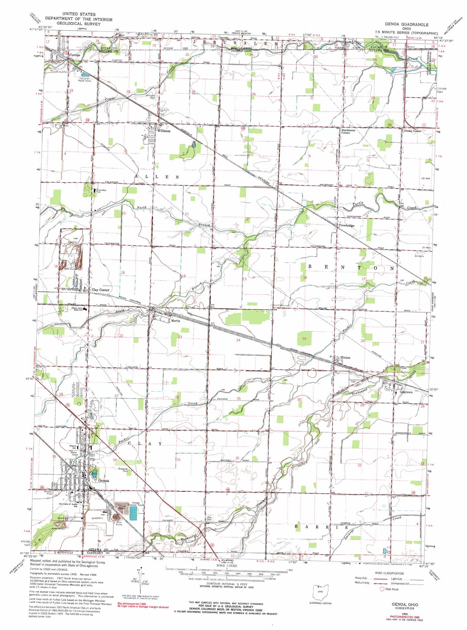
USGS Topo Quad 41083e3 - 1:24,000 scale
| Topo Map Name: | Genoa |
| USGS Topo Quad ID: | 41083e3 |
| Print Size: | ca. 21 1/4" wide x 27" high |
| Southeast Coordinates: | 41.5° N latitude / 83.25° W longitude |
| Map Center Coordinates: | 41.5625° N latitude / 83.3125° W longitude |
| U.S. State: | OH |
| Filename: | o41083e3.jpg |
| Download Map JPG Image: | Genoa topo map 1:24,000 scale |
| Map Type: | Topographic |
| Topo Series: | 7.5´ |
| Map Scale: | 1:24,000 |
| Source of Map Images: | United States Geological Survey (USGS) |
| Alternate Map Versions: |
Genoa OH 1935 Download PDF Buy paper map Genoa OH 1952, updated 1953 Download PDF Buy paper map Genoa OH 1952, updated 1964 Download PDF Buy paper map Genoa OH 1966, updated 1968 Download PDF Buy paper map Genoa OH 1966, updated 1991 Download PDF Buy paper map Genoa OH 2010 Download PDF Buy paper map Genoa OH 2013 Download PDF Buy paper map Genoa OH 2016 Download PDF Buy paper map |
1:24,000 Topo Quads surrounding Genoa
Lambertville East |
Erie |
|||
Toledo |
Oregon |
Reno Beach |
Metzger Marsh |
|
Rossford |
Walbridge |
Genoa |
Oak Harbor |
Lacarne |
Dunbridge |
Pemberville |
Elmore |
Lindsey |
Wightmans Grove |
Jerry City |
Bradner |
Helena |
Fremont West |
Fremont East |
> Back to 41083e1 at 1:100,000 scale
> Back to 41082a1 at 1:250,000 scale
> Back to U.S. Topo Maps home
Genoa topo map: Gazetteer
Genoa: Airports
Bea-d Airport elevation 184m 603′Chippewa Field elevation 180m 590′
Toussaint Airpark elevation 184m 603′
Genoa: Populated Places
Blackberry Corner elevation 178m 583′Clay Center elevation 186m 610′
Curtice elevation 180m 590′
Elliston elevation 183m 600′
Genoa elevation 191m 626′
Graytown elevation 181m 593′
Grodis Corner elevation 177m 580′
Martin elevation 184m 603′
Middleton (historical) elevation 183m 600′
Sheldon (historical) elevation 178m 583′
Trowbridge elevation 180m 590′
Williston elevation 182m 597′
Genoa: Post Offices
Clay Center Post Office elevation 186m 610′Curtice Post Office elevation 180m 590′
Elliston Post Office elevation 183m 600′
Genoa Post Office elevation 191m 626′
Graytown Post Office elevation 181m 593′
Martin Post Office elevation 184m 603′
Trowbridge Post Office (historical) elevation 179m 587′
Williston Post Office elevation 174m 570′
Genoa: Streams
North Branch Turtle Creek elevation 178m 583′South Branch Turtle Creek elevation 178m 583′
Genoa digital topo map on disk
Buy this Genoa topo map showing relief, roads, GPS coordinates and other geographical features, as a high-resolution digital map file on DVD:
 map DVD")