Maumee Topo Map Ohio
To zoom in, hover over the map of Maumee
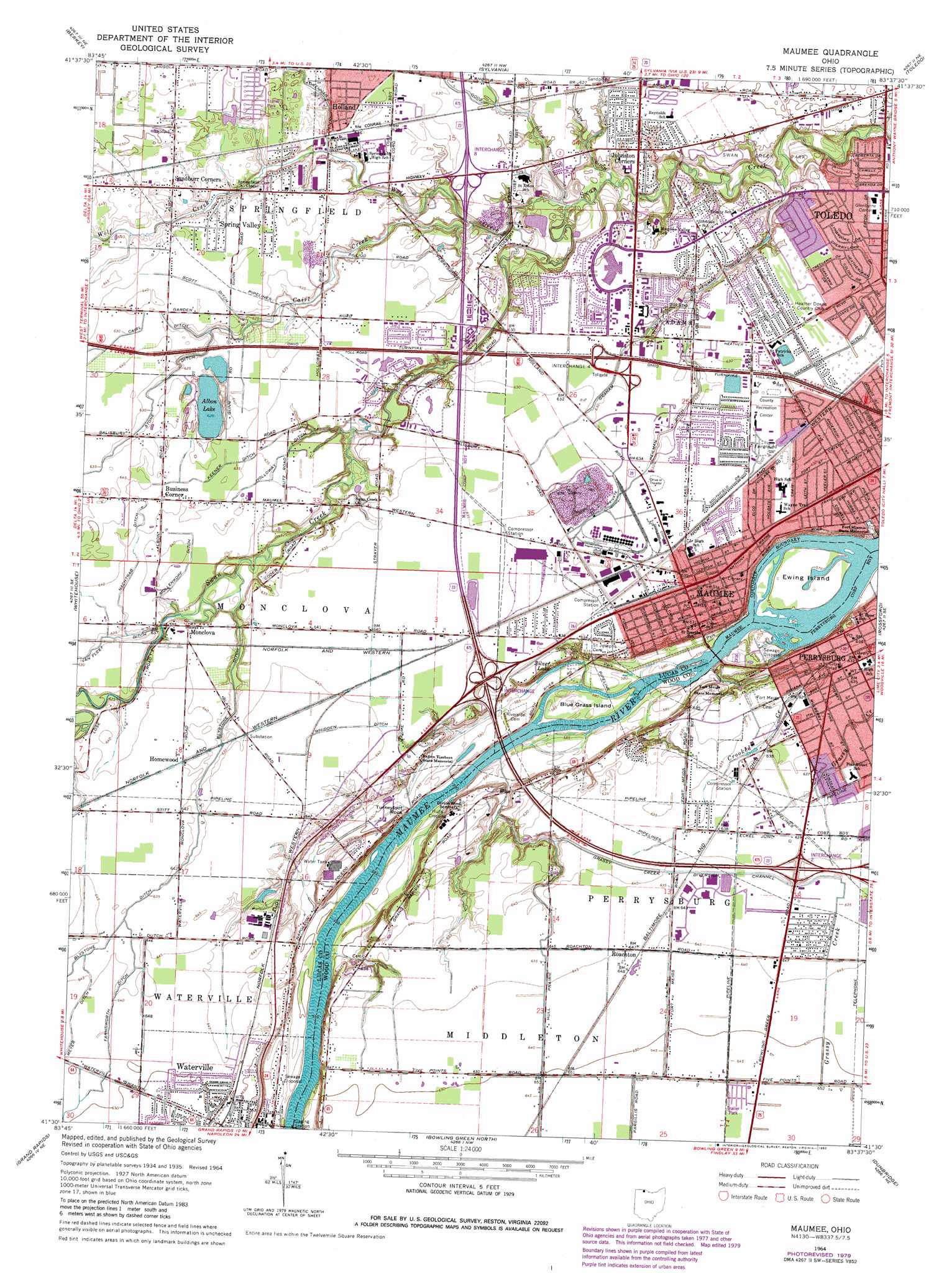
USGS Topo Quad 41083e6 - 1:24,000 scale
| Topo Map Name: | Maumee |
| USGS Topo Quad ID: | 41083e6 |
| Print Size: | ca. 21 1/4" wide x 27" high |
| Southeast Coordinates: | 41.5° N latitude / 83.625° W longitude |
| Map Center Coordinates: | 41.5625° N latitude / 83.6875° W longitude |
| U.S. State: | OH |
| Filename: | o41083e6.jpg |
| Download Map JPG Image: | Maumee topo map 1:24,000 scale |
| Map Type: | Topographic |
| Topo Series: | 7.5´ |
| Map Scale: | 1:24,000 |
| Source of Map Images: | United States Geological Survey (USGS) |
| Alternate Map Versions: |
Maumee OH 1935 Download PDF Buy paper map Maumee OH 1951, updated 1952 Download PDF Buy paper map Maumee OH 1951, updated 1960 Download PDF Buy paper map Maumee OH 1964, updated 1965 Download PDF Buy paper map Maumee OH 1964, updated 1969 Download PDF Buy paper map Maumee OH 1964, updated 1980 Download PDF Buy paper map Maumee OH 1994, updated 1998 Download PDF Buy paper map Maumee OH 2010 Download PDF Buy paper map Maumee OH 2013 Download PDF Buy paper map Maumee OH 2016 Download PDF Buy paper map |
1:24,000 Topo Quads surrounding Maumee
Palmyra |
Blissfield |
Lambertville West |
Lambertville East |
Erie |
Assumption |
Berkey |
Sylvania |
Toledo |
Oregon |
Swanton |
Whitehouse |
Maumee |
Rossford |
Walbridge |
Colton |
Grand Rapids |
Bowling Green North |
Dunbridge |
Pemberville |
Mcclure |
Weston |
Bowling Green South |
Jerry City |
Bradner |
> Back to 41083e1 at 1:100,000 scale
> Back to 41082a1 at 1:250,000 scale
> Back to U.S. Topo Maps home
Maumee topo map: Gazetteer
Maumee: Airports
Dices Personal Heliport elevation 191m 626′Saint Lukes Hospital Heliport elevation 195m 639′
Welded Heliport elevation 193m 633′
Maumee: Canals
Farnsworth Ditch elevation 195m 639′Gerdes Ditch elevation 190m 623′
Good Ditch elevation 189m 620′
Graham Ditch elevation 190m 623′
Heilman Ditch elevation 189m 620′
Holloway Ditch elevation 192m 629′
Keener Ditch elevation 193m 633′
Long Ditch elevation 190m 623′
Maumee Sidecut elevation 177m 580′
Meyer Ditch elevation 196m 643′
Mollenkope Ditch elevation 193m 633′
Nachtrab Ditch elevation 193m 633′
Scott Ditch elevation 194m 636′
Smith Ditch elevation 189m 620′
Whidden Ditch elevation 195m 639′
Maumee: Capes
Sentinel Point elevation 175m 574′Maumee: Channels
Grassy Creek Diversion Channel elevation 192m 629′Maumee: Crossings
Interchange 2 elevation 198m 649′Interchange 4 elevation 193m 633′
Interchange 4 elevation 193m 633′
Interchange 8 elevation 192m 629′
Maumee: Islands
Blue Grass Island elevation 178m 583′Ewing Island elevation 175m 574′
Grape Island elevation 177m 580′
Maumee: Lakes
Albon Lake elevation 198m 649′Silver Lake elevation 179m 587′
Maumee: Mines
Maumee Quarry elevation 187m 613′Maumee: Parks
Audubon Islands Nature Preserve elevation 174m 570′Baer Park elevation 198m 649′
Bicentennial Park elevation 194m 636′
Buttonwood-Betty C Black Recreation Area elevation 179m 587′
Conrad Park elevation 198m 649′
Fallen Timbers State Memorial elevation 193m 633′
Fort Meigs State Memorial elevation 191m 626′
Fort Miamis State Memorial elevation 190m 623′
Hood Park elevation 190m 623′
Laurel Hill Swim and Tennis Club elevation 186m 610′
Lucas County Recreation Center elevation 192m 629′
Maumee Historic District elevation 193m 633′
Maumee Uptown Historic District elevation 193m 633′
Orleans Park elevation 176m 577′
Perrysburg Historic District elevation 192m 629′
Rivercrest Park elevation 193m 633′
Riverside Park elevation 180m 590′
Side Cut Metropark elevation 178m 583′
Swan Creek Preserve Metropark elevation 186m 610′
Towpath Park elevation 178m 583′
Waterville Commercial Historic District elevation 187m 613′
Maumee: Populated Places
Business Corner elevation 196m 643′Carrington Woods elevation 185m 606′
Crandenbrook elevation 194m 636′
D'Arcy Estates elevation 192m 629′
Fort Meigs Place elevation 193m 633′
Holland elevation 195m 639′
Homewood elevation 195m 639′
Hulls Crossing elevation 178m 583′
Indian Meadows elevation 194m 636′
Johnston Corners elevation 190m 623′
Kettle Run elevation 193m 633′
Maumee elevation 193m 633′
McKinley Woods elevation 192m 629′
Meigs on the River elevation 192m 629′
Monclova elevation 193m 633′
Perrysburg elevation 192m 629′
Perrysburg Heights elevation 194m 636′
Presque Isle (historical) elevation 193m 633′
Rivercrest elevation 193m 633′
Riverford elevation 193m 633′
Roachton elevation 196m 643′
Sandburr Corners elevation 195m 639′
Southview Estates Mobile Home Park elevation 198m 649′
Spring Valley elevation 194m 636′
The Estates of Fort Meigs elevation 193m 633′
Waterville elevation 187m 613′
Willowbend elevation 194m 636′
Maumee: Post Offices
Holland Post Office elevation 195m 639′Maumee Post Office elevation 193m 633′
Monclova Post Office elevation 194m 636′
Perrysburg Post Office elevation 192m 629′
Presque Isle Post Office (historical) elevation 192m 629′
Waterville Post Office elevation 187m 613′
Maumee: Rapids
Maumee Rapids elevation 180m 590′Maumee: Streams
Cairl Creek elevation 188m 616′Crooked Creek elevation 175m 574′
Wolf Creek elevation 182m 597′
Maumee: Summits
Indian Hill elevation 193m 633′Turkeyfoot Rock elevation 181m 593′
Maumee digital topo map on disk
Buy this Maumee topo map showing relief, roads, GPS coordinates and other geographical features, as a high-resolution digital map file on DVD:
 map DVD")