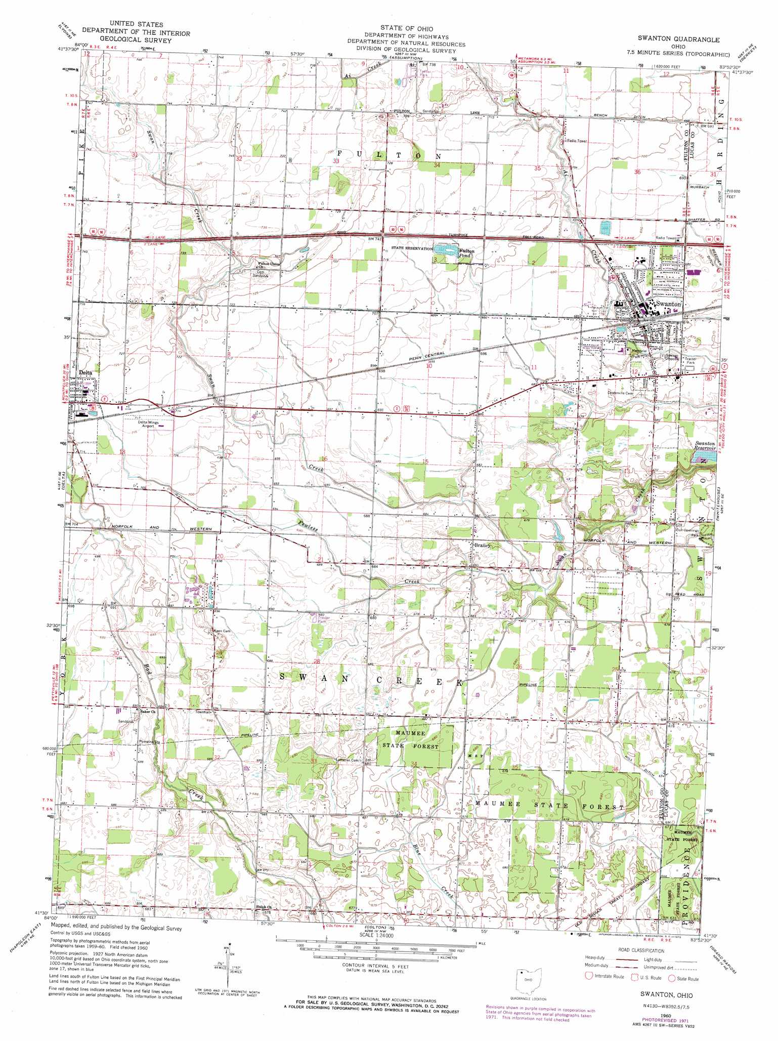
Swanton Topo Map Ohio
To zoom in, hover over the map of Swanton
USGS Topo Quad 41083e8 - 1:24,000 scale
| Topo Map Name: | Swanton |
| USGS Topo Quad ID: | 41083e8 |
| Print Size: | ca. 21 1/4" wide x 27" high |
| Southeast Coordinates: | 41.5° N latitude / 83.875° W longitude |
| Map Center Coordinates: | 41.5625° N latitude / 83.9375° W longitude |
| U.S. State: | OH |
| Filename: | o41083e8.jpg |
| Download Map JPG Image: | Swanton topo map 1:24,000 scale |
| Map Type: | Topographic |
| Topo Series: | 7.5´ |
| Map Scale: | 1:24,000 |
| Source of Map Images: | United States Geological Survey (USGS) |
| Alternate Map Versions: |
Swanton OH 1960, updated 1962 Download PDF Buy paper map Swanton OH 1960, updated 1972 Download PDF Buy paper map Swanton OH 2010 Download PDF Buy paper map Swanton OH 2013 Download PDF Buy paper map Swanton OH 2016 Download PDF Buy paper map |
1:24,000 Topo Quads surrounding Swanton
Clayton |
Jasper |
Palmyra |
Blissfield |
Lambertville West |
Morenci |
Lyons |
Assumption |
Berkey |
Sylvania |
Wauseon |
Delta |
Swanton |
Whitehouse |
Maumee |
Napoleon West |
Napoleon East |
Colton |
Grand Rapids |
Bowling Green North |
Florida |
Malinta |
Mcclure |
Weston |
Bowling Green South |
> Back to 41083e1 at 1:100,000 scale
> Back to 41082a1 at 1:250,000 scale
> Back to U.S. Topo Maps home
Swanton topo map: Gazetteer
Swanton: Airports
Delta Wings Airport elevation 217m 711′Swanton: Canals
Beecher Ditch elevation 207m 679′Hill Ditch elevation 205m 672′
Swanton: Lakes
Fulton Pond elevation 214m 702′Swanton: Parks
Fulton Pond Wildlife Area elevation 215m 705′Memorial Park elevation 203m 666′
Swanton: Populated Places
Brailey elevation 206m 675′Peaceful Valley elevation 214m 702′
Raker Corners elevation 210m 688′
South Delta elevation 214m 702′
Swanton elevation 208m 682′
Swanton: Post Offices
Swanton Post Office elevation 209m 685′Swanton: Streams
Fewless Creek elevation 201m 659′Swanton digital topo map on disk
Buy this Swanton topo map showing relief, roads, GPS coordinates and other geographical features, as a high-resolution digital map file on DVD:
 map DVD")