Reno Beach Topo Map Ohio
To zoom in, hover over the map of Reno Beach
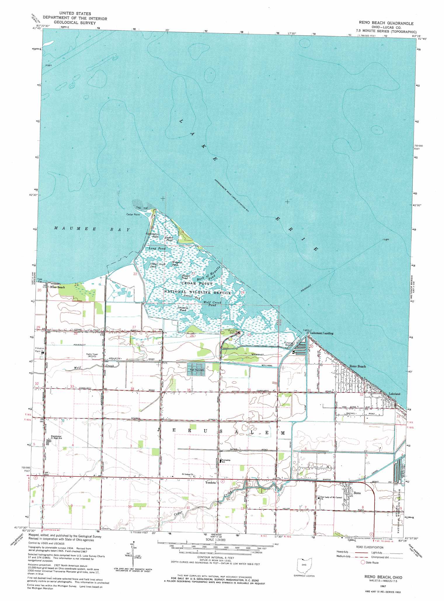
USGS Topo Quad 41083f3 - 1:24,000 scale
| Topo Map Name: | Reno Beach |
| USGS Topo Quad ID: | 41083f3 |
| Print Size: | ca. 21 1/4" wide x 27" high |
| Southeast Coordinates: | 41.625° N latitude / 83.25° W longitude |
| Map Center Coordinates: | 41.6875° N latitude / 83.3125° W longitude |
| U.S. State: | OH |
| Filename: | o41083f3.jpg |
| Download Map JPG Image: | Reno Beach topo map 1:24,000 scale |
| Map Type: | Topographic |
| Topo Series: | 7.5´ |
| Map Scale: | 1:24,000 |
| Source of Map Images: | United States Geological Survey (USGS) |
| Alternate Map Versions: |
Reno Beach OH 1934 Download PDF Buy paper map Reno Beach OH 1952, updated 1953 Download PDF Buy paper map Reno Beach OH 1967, updated 1968 Download PDF Buy paper map Reno Beach OH 2010 Download PDF Buy paper map Reno Beach OH 2013 Download PDF Buy paper map Reno Beach OH 2016 Download PDF Buy paper map |
1:24,000 Topo Quads surrounding Reno Beach
Ida |
Monroe |
Stony Point |
Estral Beach |
|
Lambertville East |
Erie |
|||
Toledo |
Oregon |
Reno Beach |
Metzger Marsh |
|
Rossford |
Walbridge |
Genoa |
Oak Harbor |
Lacarne |
Dunbridge |
Pemberville |
Elmore |
Lindsey |
Wightmans Grove |
> Back to 41083e1 at 1:100,000 scale
> Back to 41082a1 at 1:250,000 scale
> Back to U.S. Topo Maps home
Reno Beach topo map: Gazetteer
Reno Beach: Bays
Paynes Pond elevation 175m 574′Potters Pond elevation 175m 574′
Secor Bay elevation 175m 574′
Suzar Bay elevation 175m 574′
Reno Beach: Beaches
Lamb Beach elevation 175m 574′Reno Beach: Canals
Berger Road Ditch elevation 175m 574′Reno Side Cut elevation 174m 570′
Sautter Ditch elevation 175m 574′
Wards Canal elevation 175m 574′
Williams Ditch elevation 174m 570′
Reno Beach: Capes
Cedar Point elevation 174m 570′Reno Beach: Lakes
Goose Pond elevation 175m 574′Hannah Pond (historical) elevation 175m 574′
Haskell Pond (historical) elevation 175m 574′
Niles Pond (historical) elevation 175m 574′
Wolf Creek Pond elevation 174m 570′
Reno Beach: Parks
Cedar Point National Wildlife Refuge elevation 175m 574′Mallard Club Marsh State Wildlife Area elevation 175m 574′
Reno Beach: Populated Places
Bono elevation 176m 577′Lakeland elevation 174m 570′
Lakemont Landing elevation 174m 570′
New Jerusalem (historical) elevation 175m 574′
Niles Beach elevation 175m 574′
Reno Beach elevation 174m 570′
Yondota elevation 175m 574′
Reno Beach: Post Offices
Bono Post Office (historical) elevation 175m 574′Yondota Post Office (historical) elevation 175m 574′
Reno Beach: Reservoirs
Back of Howells Pond elevation 175m 574′Carrington Pond elevation 175m 574′
Cedar Creek Pond elevation 175m 574′
Lacourse Pond elevation 175m 574′
Long Pond elevation 175m 574′
Outlet Pond elevation 175m 574′
Pintail Pond elevation 175m 574′
Widgeon Pond elevation 175m 574′
Reno Beach: Streams
Cedar Creek elevation 175m 574′Wolf Creek elevation 175m 574′
Reno Beach: Swamps
Cedar Point Marsh elevation 175m 574′Mallard Club Marsh elevation 175m 574′
Reno Beach digital topo map on disk
Buy this Reno Beach topo map showing relief, roads, GPS coordinates and other geographical features, as a high-resolution digital map file on DVD:
 map DVD")