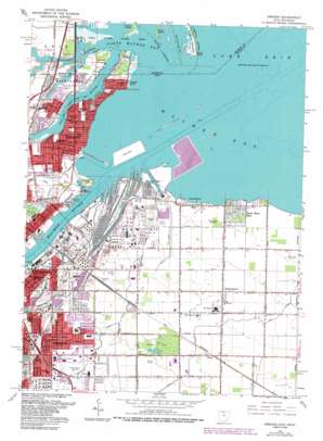
Oregon Topo Map Ohio
To zoom in, hover over the map of Oregon
USGS Topo Quad 41083f4 - 1:24,000 scale
| Topo Map Name: | Oregon |
| USGS Topo Quad ID: | 41083f4 |
| Print Size: | ca. 21 1/4" wide x 27" high |
| Southeast Coordinates: | 41.625° N latitude / 83.375° W longitude |
| Map Center Coordinates: | 41.6875° N latitude / 83.4375° W longitude |
| U.S. States: | OH, MI |
| Filename: | o41083f4.jpg |
| Download Map JPG Image: | Oregon topo map 1:24,000 scale |
| Map Type: | Topographic |
| Topo Series: | 7.5´ |
| Map Scale: | 1:24,000 |
| Source of Map Images: | United States Geological Survey (USGS) |
| Alternate Map Versions: |
Point Place OH 1934 Download PDF Buy paper map Point Place OH 1952, updated 1954 Download PDF Buy paper map Oregon OH 1965, updated 1966 Download PDF Buy paper map Oregon OH 1965, updated 1976 Download PDF Buy paper map Oregon OH 1965, updated 1980 Download PDF Buy paper map Oregon OH 1965, updated 1986 Download PDF Buy paper map Oregon OH 1965, updated 1986 Download PDF Buy paper map Oregon OH 2011 Download PDF Buy paper map Oregon OH 2013 Download PDF Buy paper map Oregon OH 2016 Download PDF Buy paper map |
1:24,000 Topo Quads surrounding Oregon
> Back to 41083e1 at 1:100,000 scale
> Back to 41082a1 at 1:250,000 scale
> Back to U.S. Topo Maps home
Oregon topo map: Gazetteer
Oregon: Airports
Culver Field elevation 179m 587′Saint Charles Hospital Heliport elevation 185m 606′
Sohio Heliport elevation 178m 583′
Oregon: Bays
Maumee Bay elevation 174m 570′Maumee Mooring Basin elevation 177m 580′
North Maumee Bay elevation 174m 570′
Oregon: Beaches
Carland Beach elevation 175m 574′Erie Beach elevation 175m 574′
Oregon: Canals
Amolsch Ditch elevation 178m 583′Condin Ditch elevation 178m 583′
Detwiler Ditch elevation 175m 574′
Driftmeyer Ditch elevation 177m 580′
Entrance Channel elevation 174m 570′
Johlin Ditch elevation 178m 583′
Wolf Ditch elevation 180m 590′
Oregon: Capes
Dry Tree Point elevation 175m 574′Grass Point elevation 175m 574′
Morin Point elevation 175m 574′
North Cape elevation 177m 580′
Oregon: Channels
Entrance Channel elevation 174m 570′Oregon: Crossings
Interchange 7 elevation 182m 597′Interchange 8 elevation 180m 590′
Oregon: Harbors
Maumee Mooring Basin elevation 176m 577′Oregon: Islands
Gard Island elevation 174m 570′Grassy Island elevation 174m 570′
Indian Island elevation 175m 574′
Nagg Island elevation 176m 577′
Presque Isle elevation 177m 580′
Oregon: Parks
Bay View Park elevation 176m 577′Collins Park elevation 180m 590′
Cullen Park elevation 176m 577′
Detwiler Park elevation 174m 570′
Friendship Park elevation 176m 577′
Maumee Bay State Park elevation 176m 577′
Pearson Metropark elevation 182m 597′
Ravine Park elevation 179m 587′
Shoreland Park elevation 177m 580′
Oregon: Populated Places
Booth elevation 182m 597′Harbor View elevation 177m 580′
Immergrun elevation 176m 577′
Ironville elevation 179m 587′
Momeneetown elevation 180m 590′
Oregon elevation 183m 600′
Point Place elevation 177m 580′
Ryan elevation 185m 606′
Shore Acres elevation 178m 583′
South Shore Park elevation 176m 577′
Willow Beach elevation 177m 580′
Oregon: Post Offices
Harbor View Post Office elevation 177m 580′Ironville Post Office (historical) elevation 179m 587′
Momeneetown Post Office (historical) elevation 180m 590′
Oregon Post Office (historical) elevation 183m 600′
Oregon: Streams
Duck Creek elevation 175m 574′Halfway Creek elevation 174m 570′
Halfway Creek elevation 174m 570′
Maumee River elevation 177m 580′
Mud Creek elevation 174m 570′
Ottawa River elevation 174m 570′
Ottawa River elevation 174m 570′
Otter Creek elevation 175m 574′
Shantee Creek elevation 174m 570′
Silver Creek elevation 175m 574′
Silver Creek elevation 175m 574′
Silver Creek elevation 175m 574′
Oregon digital topo map on disk
Buy this Oregon topo map showing relief, roads, GPS coordinates and other geographical features, as a high-resolution digital map file on DVD:


