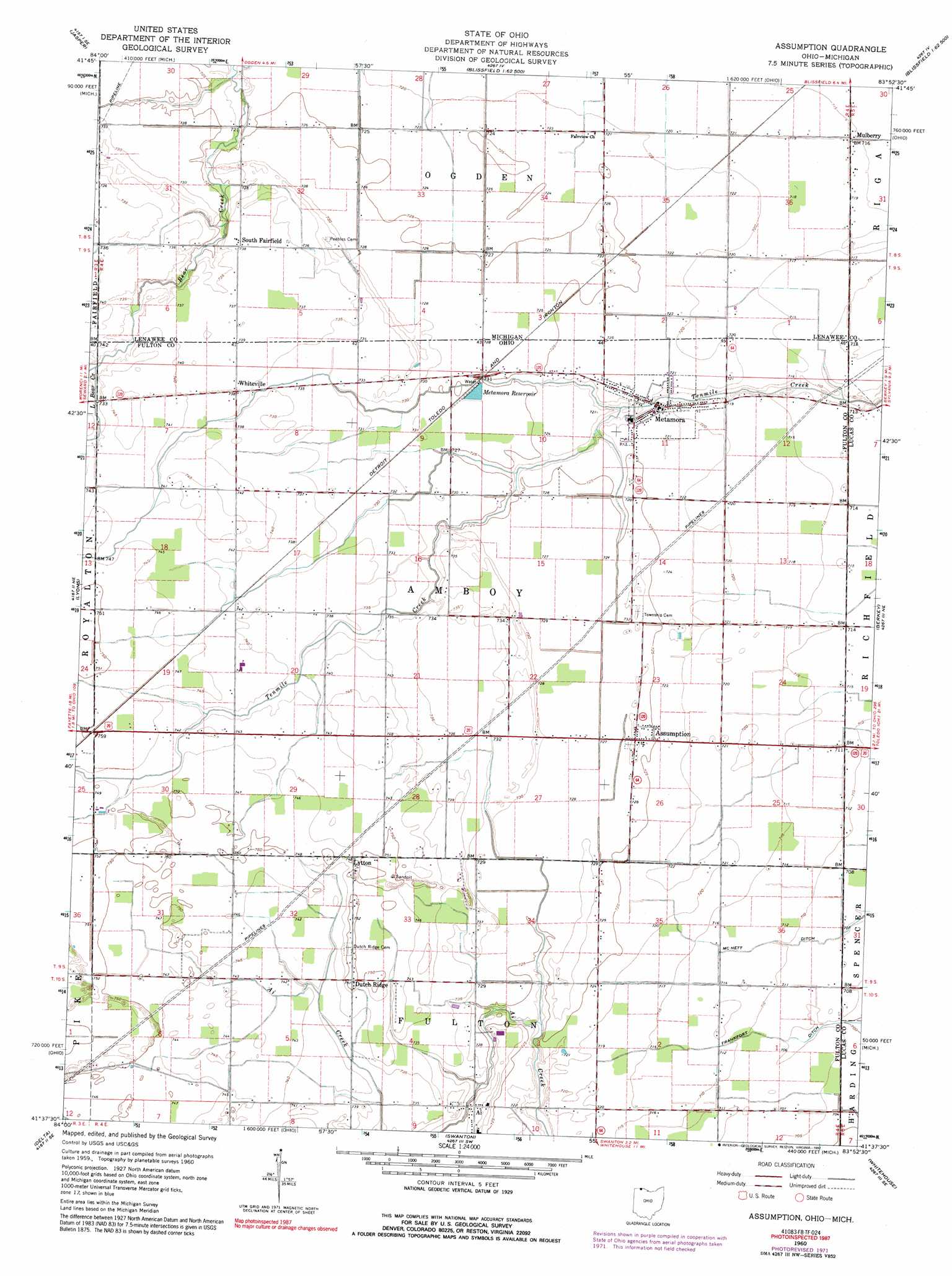
Assumption Topo Map Ohio
To zoom in, hover over the map of Assumption
USGS Topo Quad 41083f8 - 1:24,000 scale
| Topo Map Name: | Assumption |
| USGS Topo Quad ID: | 41083f8 |
| Print Size: | ca. 21 1/4" wide x 27" high |
| Southeast Coordinates: | 41.625° N latitude / 83.875° W longitude |
| Map Center Coordinates: | 41.6875° N latitude / 83.9375° W longitude |
| U.S. States: | OH, MI |
| Filename: | o41083f8.jpg |
| Download Map JPG Image: | Assumption topo map 1:24,000 scale |
| Map Type: | Topographic |
| Topo Series: | 7.5´ |
| Map Scale: | 1:24,000 |
| Source of Map Images: | United States Geological Survey (USGS) |
| Alternate Map Versions: |
Assumption OH 1960, updated 1962 Download PDF Buy paper map Assumption OH 1960, updated 1972 Download PDF Buy paper map Assumption OH 1960, updated 1992 Download PDF Buy paper map Assumption OH 2011 Download PDF Buy paper map Assumption OH 2013 Download PDF Buy paper map Assumption OH 2016 Download PDF Buy paper map |
1:24,000 Topo Quads surrounding Assumption
Rome Center |
Adrian |
Tecumseh South |
Deerfield |
Dundee |
Clayton |
Jasper |
Palmyra |
Blissfield |
Lambertville West |
Morenci |
Lyons |
Assumption |
Berkey |
Sylvania |
Wauseon |
Delta |
Swanton |
Whitehouse |
Maumee |
Napoleon West |
Napoleon East |
Colton |
Grand Rapids |
Bowling Green North |
> Back to 41083e1 at 1:100,000 scale
> Back to 41082a1 at 1:250,000 scale
> Back to U.S. Topo Maps home
Assumption topo map: Gazetteer
Assumption: Populated Places
Ai elevation 223m 731′Assumption elevation 222m 728′
Champion elevation 221m 725′
Dutch Ridge elevation 229m 751′
Leslie (historical) elevation 224m 734′
Lytton elevation 228m 748′
Metamora elevation 220m 721′
Mulberry elevation 218m 715′
Siney (historical) elevation 228m 748′
South Fairfield elevation 224m 734′
Townline (historical) elevation 223m 731′
Treadway (historical) elevation 216m 708′
Whiteville elevation 224m 734′
Assumption: Post Offices
Ai Post Office (historical) elevation 224m 734′Leslie Post Office (historical) elevation 223m 731′
Lytton Post Office (historical) elevation 228m 748′
Metamora Post Office elevation 220m 721′
Mulberry Post Office (historical) elevation 218m 715′
Siney Post Office (historical) elevation 229m 751′
South Fairfield Post Office (historical) elevation 224m 734′
Whiteville Post Office (historical) elevation 224m 734′
Assumption: Reservoirs
Metamora Reservoir elevation 220m 721′Assumption: Streams
Little Bear Creek elevation 222m 728′Assumption digital topo map on disk
Buy this Assumption topo map showing relief, roads, GPS coordinates and other geographical features, as a high-resolution digital map file on DVD:
 map DVD")