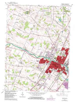
Monroe Topo Map Michigan
To zoom in, hover over the map of Monroe
USGS Topo Quad 41083h4 - 1:24,000 scale
| Topo Map Name: | Monroe |
| USGS Topo Quad ID: | 41083h4 |
| Print Size: | ca. 21 1/4" wide x 27" high |
| Southeast Coordinates: | 41.875° N latitude / 83.375° W longitude |
| Map Center Coordinates: | 41.9375° N latitude / 83.4375° W longitude |
| U.S. State: | MI |
| Filename: | o41083h4.jpg |
| Download Map JPG Image: | Monroe topo map 1:24,000 scale |
| Map Type: | Topographic |
| Topo Series: | 7.5´ |
| Map Scale: | 1:24,000 |
| Source of Map Images: | United States Geological Survey (USGS) |
| Alternate Map Versions: |
Monroe MI 1942, updated 1942 Download PDF Buy paper map Monroe MI 1952, updated 1954 Download PDF Buy paper map Monroe MI 1967, updated 1969 Download PDF Buy paper map Monroe MI 1967, updated 1979 Download PDF Buy paper map Monroe MI 1967, updated 1979 Download PDF Buy paper map Monroe MI 2011 Download PDF Buy paper map Monroe MI 2014 Download PDF Buy paper map Monroe MI 2016 Download PDF Buy paper map |
1:24,000 Topo Quads surrounding Monroe
> Back to 41083e1 at 1:100,000 scale
> Back to 41082a1 at 1:250,000 scale
> Back to U.S. Topo Maps home
Monroe topo map: Gazetteer
Monroe: Airports
Custer Airport elevation 187m 613′Monroe: Canals
Bates Drain elevation 184m 603′Grosvenor Drain elevation 180m 590′
Ives Drain elevation 181m 593′
Monroe: Crossings
Interchange 11 elevation 177m 580′Monroe: Islands
Kauslers Island elevation 175m 574′Sisters Island elevation 178m 583′
Sterling Island elevation 175m 574′
Strong Island elevation 174m 570′
Monroe: Lakes
Twin Lakes elevation 190m 623′Monroe: Parks
Cranbrook Park elevation 183m 600′Father Carnes Park elevation 182m 597′
George Armstrong Custer Historical Marker elevation 180m 590′
Hellenberg Park elevation 175m 574′
Manor Park elevation 183m 600′
Monroe Historical Marker (historical) elevation 181m 593′
Munson Park elevation 185m 606′
Roessler Park elevation 181m 593′
Saint John the Baptist Catholic Church Historical Marker elevation 182m 597′
Saint Mary's Park elevation 180m 590′
Sighting the Enemy Historical Marker elevation 180m 590′
Soldiers and Sailors Park elevation 178m 583′
Veterans Park elevation 180m 590′
Waterloo Park elevation 183m 600′
Monroe: Populated Places
Evergreen Acres elevation 183m 600′Holiday South Mobile Home Park elevation 183m 600′
Meadowbrook Estates Mobile Home Park elevation 182m 597′
Monroe elevation 181m 593′
Oakridge Estates Mobile Home Park elevation 181m 593′
Patterson Gardens elevation 184m 603′
Raisin Ridge Estate and Mobile Home Park elevation 178m 583′
Shamrock Mobile Home Village elevation 184m 603′
South Monroe elevation 182m 597′
Steiner elevation 187m 613′
West Monroe elevation 183m 600′
Willow Green Mobile Home Park elevation 183m 600′
Monroe: Post Offices
Monroe Post Office elevation 181m 593′North Raisinville Post Office (historical) elevation 187m 613′
Steiner Post Office (historical) elevation 187m 613′
Monroe: Streams
Anweiler Drain elevation 181m 593′Brost Drain elevation 183m 600′
Brown Drain elevation 185m 606′
Burdeau Drain elevation 187m 613′
Calkins Drain elevation 183m 600′
Davis Swale elevation 175m 574′
Eby Drain elevation 190m 623′
French Creek elevation 179m 587′
Grauf Drain elevation 187m 613′
Gutnecht Drain elevation 190m 623′
Hansberger Drain elevation 187m 613′
Hoffman Drain elevation 189m 620′
Karm Drain elevation 189m 620′
Middle Branch Willow Run elevation 187m 613′
Moore Drain elevation 186m 610′
North Branch Willow Run elevation 187m 613′
Otter Creek elevation 186m 610′
Pin Oak Creek elevation 185m 606′
Pitts Creek elevation 184m 603′
Schesberger Drain elevation 187m 613′
Shurtzer Drain elevation 182m 597′
South Branch La Plaisance Creek elevation 183m 600′
Sycamore Drain elevation 186m 610′
Tamarack Creek elevation 174m 570′
Weber Drain elevation 186m 610′
Willow Run elevation 184m 603′
Monroe digital topo map on disk
Buy this Monroe topo map showing relief, roads, GPS coordinates and other geographical features, as a high-resolution digital map file on DVD:


