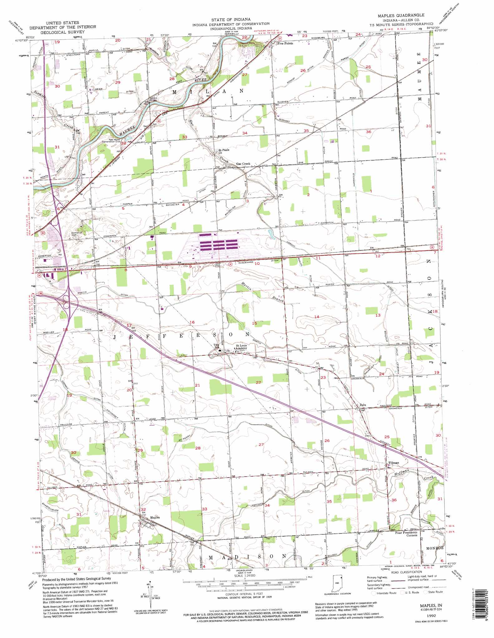
Maples Topo Map Indiana
To zoom in, hover over the map of Maples
USGS Topo Quad 41084a8 - 1:24,000 scale
| Topo Map Name: | Maples |
| USGS Topo Quad ID: | 41084a8 |
| Print Size: | ca. 21 1/4" wide x 27" high |
| Southeast Coordinates: | 41° N latitude / 84.875° W longitude |
| Map Center Coordinates: | 41.0625° N latitude / 84.9375° W longitude |
| U.S. State: | IN |
| Filename: | o41084a8.jpg |
| Download Map JPG Image: | Maples topo map 1:24,000 scale |
| Map Type: | Topographic |
| Topo Series: | 7.5´ |
| Map Scale: | 1:24,000 |
| Source of Map Images: | United States Geological Survey (USGS) |
| Alternate Map Versions: |
Maples IN 1957, updated 1959 Download PDF Buy paper map Maples IN 1957, updated 1974 Download PDF Buy paper map Maples IN 1957, updated 1982 Download PDF Buy paper map Maples IN 1992, updated 1995 Download PDF Buy paper map Maples IN 2010 Download PDF Buy paper map Maples IN 2013 Download PDF Buy paper map Maples IN 2016 Download PDF Buy paper map |
1:24,000 Topo Quads surrounding Maples
Garrett |
Auburn |
Saint Joe |
Hicksville |
Mark Center |
Huntertown |
Cedarville |
Grabill |
Woodburn North |
Antwerp |
Fort Wayne West |
Fort Wayne East |
Maples |
Woodburn South |
Payne |
Ossian |
Poe |
Hoagland |
Dixon |
Convoy |
Uniondale |
Preble |
Decatur |
Wren |
Glenmore |
> Back to 41084a1 at 1:100,000 scale
> Back to 41084a1 at 1:250,000 scale
> Back to U.S. Topo Maps home
Maples topo map: Gazetteer
Maples: Airports
Casad Industrial Park Airport elevation 231m 757′Klines Airport elevation 241m 790′
Valhalla Airport elevation 247m 810′
Maples: Canals
Bandelier Ditch elevation 232m 761′Bandelier Ditch Number Two elevation 232m 761′
Bonjour Ditch elevation 240m 787′
Converset Ditch elevation 239m 784′
Dennis Ditch elevation 239m 784′
Ellison Ditch elevation 239m 784′
Gromeaux Ditch elevation 234m 767′
Grover Ditch elevation 227m 744′
Henry Bandelier Ditch elevation 235m 770′
Huguenard Ditch elevation 232m 761′
Martin Ditch elevation 233m 764′
McHenry Ditch elevation 237m 777′
Meier Ditch elevation 227m 744′
Nahrwold Ditch elevation 227m 744′
Popitz Ditch elevation 230m 754′
Rorick Ditch elevation 236m 774′
Rushart Ditch elevation 228m 748′
Ryan Ditch elevation 235m 770′
Schaaf Ditch elevation 218m 715′
Schumacher Ditch elevation 230m 754′
Sharpenburg Ditch elevation 242m 793′
Spindler Ditch elevation 225m 738′
Summers Ditch elevation 228m 748′
Yoquelet Ditch elevation 234m 767′
Maples: Populated Places
Five Points elevation 221m 725′Maples elevation 244m 800′
Tillman elevation 237m 777′
Zulu elevation 236m 774′
Maples: Streams
Gar Creek elevation 218m 715′Martin Branch elevation 233m 764′
Sixmile Creek elevation 222m 728′
Maples digital topo map on disk
Buy this Maples topo map showing relief, roads, GPS coordinates and other geographical features, as a high-resolution digital map file on DVD:
Northern Illinois, Northern Indiana & Southwestern Michigan
Buy digital topo maps: Northern Illinois, Northern Indiana & Southwestern Michigan