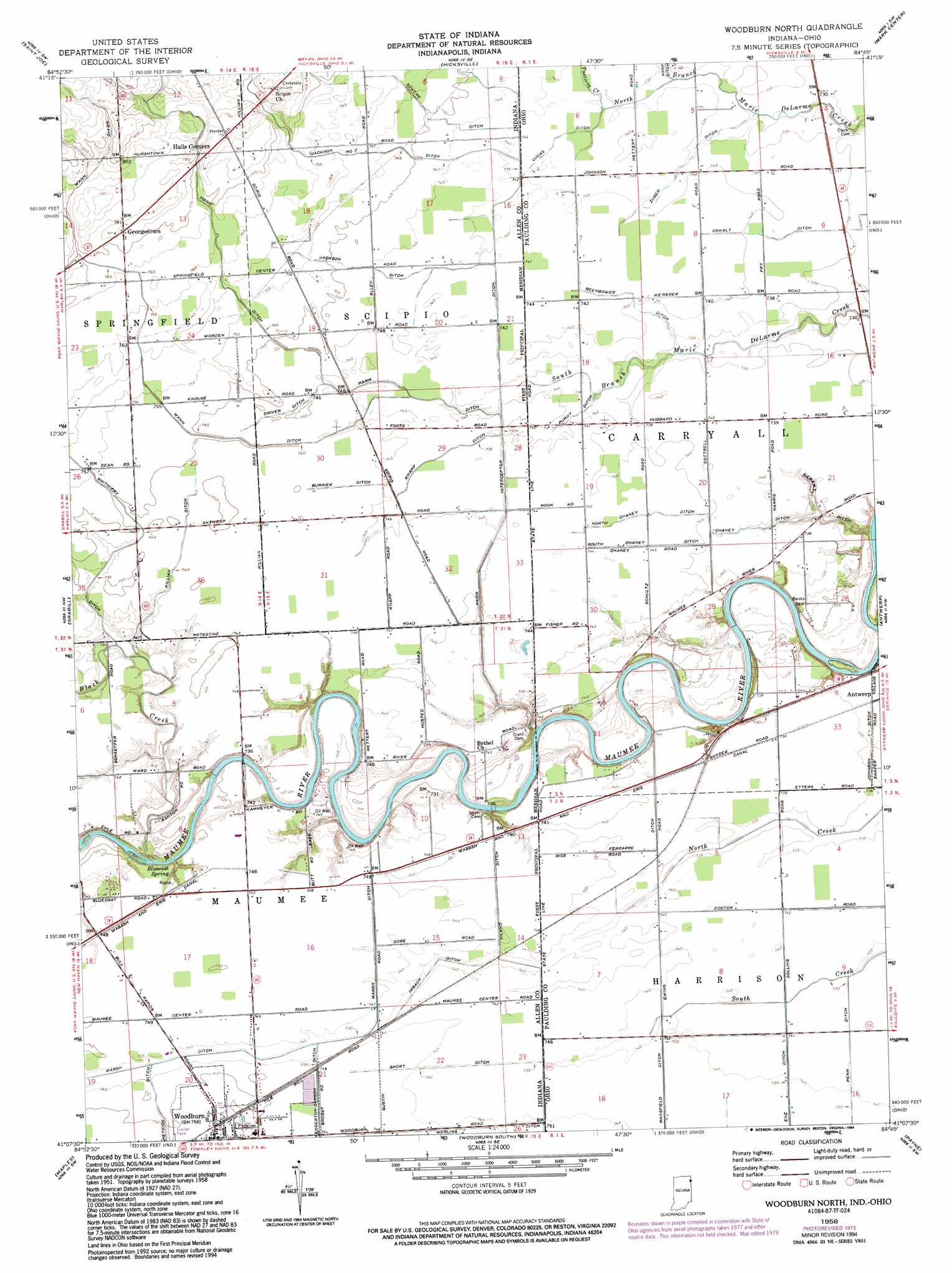
Woodburn North Topo Map Indiana
To zoom in, hover over the map of Woodburn North
USGS Topo Quad 41084b7 - 1:24,000 scale
| Topo Map Name: | Woodburn North |
| USGS Topo Quad ID: | 41084b7 |
| Print Size: | ca. 21 1/4" wide x 27" high |
| Southeast Coordinates: | 41.125° N latitude / 84.75° W longitude |
| Map Center Coordinates: | 41.1875° N latitude / 84.8125° W longitude |
| U.S. States: | IN, OH |
| Filename: | o41084b7.jpg |
| Download Map JPG Image: | Woodburn North topo map 1:24,000 scale |
| Map Type: | Topographic |
| Topo Series: | 7.5´ |
| Map Scale: | 1:24,000 |
| Source of Map Images: | United States Geological Survey (USGS) |
| Alternate Map Versions: |
Woodburn North IN 1958, updated 1960 Download PDF Buy paper map Woodburn North IN 1958, updated 1970 Download PDF Buy paper map Woodburn North IN 1958, updated 1974 Download PDF Buy paper map Woodburn North IN 1958, updated 1994 Download PDF Buy paper map Woodburn North IN 2010 Download PDF Buy paper map Woodburn North IN 2013 Download PDF Buy paper map Woodburn North IN 2016 Download PDF Buy paper map |
1:24,000 Topo Quads surrounding Woodburn North
Waterloo |
Butler West |
Butler East |
Edgerton |
Bryan |
Auburn |
Saint Joe |
Hicksville |
Mark Center |
Sherwood |
Cedarville |
Grabill |
Woodburn North |
Antwerp |
Paulding |
Fort Wayne East |
Maples |
Woodburn South |
Payne |
Latty |
Poe |
Hoagland |
Dixon |
Convoy |
Scott |
> Back to 41084a1 at 1:100,000 scale
> Back to 41084a1 at 1:250,000 scale
> Back to U.S. Topo Maps home
Woodburn North topo map: Gazetteer
Woodburn North: Canals
Beerbower Ditch elevation 225m 738′Burrier Ditch elevation 227m 744′
Chaney Ditch elevation 224m 734′
Driver Ditch elevation 227m 744′
Enz Ditch elevation 227m 744′
Ferrarre Ditch elevation 224m 734′
Hamm Ditch elevation 232m 761′
Hamm Interceptor Ditch elevation 223m 731′
Hetrick Ditch elevation 228m 748′
Imbach Ditch elevation 224m 734′
Jackson Ditch elevation 225m 738′
Jackson Number Two Ditch elevation 235m 770′
Johnson Ditch elevation 224m 734′
Killian Ditch elevation 227m 744′
Knapp Ditch elevation 225m 738′
Lucas Ditch elevation 224m 734′
North Chaney Ditch elevation 225m 738′
Penn Ditch elevation 225m 738′
Purdy Ditch elevation 224m 734′
Short Ditch elevation 226m 741′
Sieberi Ditch elevation 220m 721′
South Chaney Ditch elevation 225m 738′
Sowers Ditch elevation 227m 744′
Viland Ditch elevation 222m 728′
Wann Ditch elevation 228m 748′
Werling Ditch elevation 227m 744′
Zuber Ditch elevation 224m 734′
Woodburn North: Populated Places
Bluecast elevation 227m 744′Georgetown elevation 239m 784′
Halls Corners elevation 240m 787′
Jarrett Wood Subdivision elevation 223m 731′
Lichtys Parcels elevation 224m 734′
Link (historical) elevation 225m 738′
New Harrison (historical) elevation 226m 741′
Nindeville (historical) elevation 224m 734′
Woodburn elevation 229m 751′
Woodburn North: Post Offices
Link Post Office (historical) elevation 225m 738′Woodburn North: Springs
Bluecast Spring elevation 223m 731′Woodburn North: Streams
Black Creek elevation 217m 711′Tustison Creek elevation 224m 734′
Woodburn North digital topo map on disk
Buy this Woodburn North topo map showing relief, roads, GPS coordinates and other geographical features, as a high-resolution digital map file on DVD:
Northern Illinois, Northern Indiana & Southwestern Michigan
Buy digital topo maps: Northern Illinois, Northern Indiana & Southwestern Michigan