Saint Joe Topo Map Indiana
To zoom in, hover over the map of Saint Joe
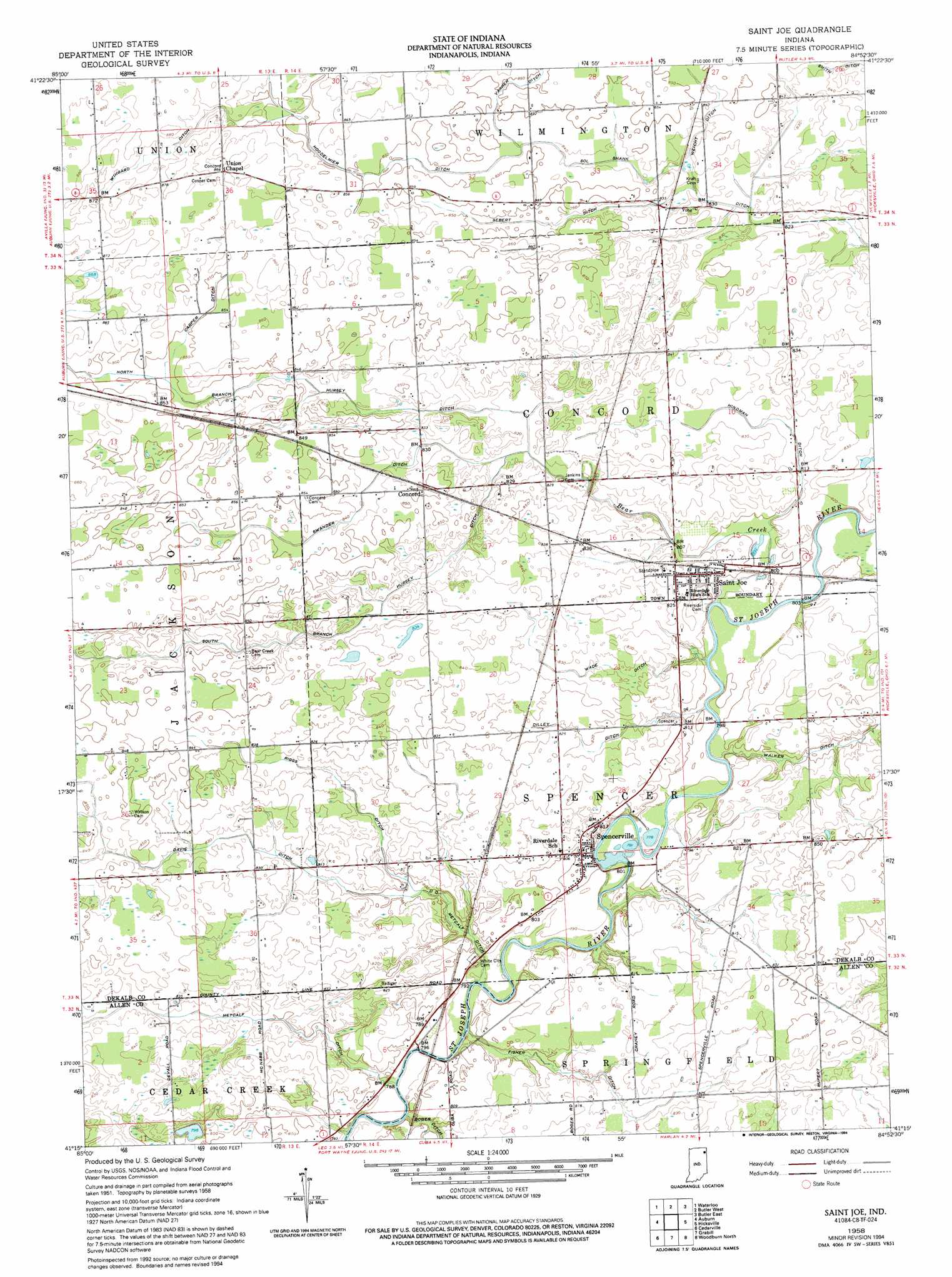
USGS Topo Quad 41084c8 - 1:24,000 scale
| Topo Map Name: | Saint Joe |
| USGS Topo Quad ID: | 41084c8 |
| Print Size: | ca. 21 1/4" wide x 27" high |
| Southeast Coordinates: | 41.25° N latitude / 84.875° W longitude |
| Map Center Coordinates: | 41.3125° N latitude / 84.9375° W longitude |
| U.S. State: | IN |
| Filename: | o41084c8.jpg |
| Download Map JPG Image: | Saint Joe topo map 1:24,000 scale |
| Map Type: | Topographic |
| Topo Series: | 7.5´ |
| Map Scale: | 1:24,000 |
| Source of Map Images: | United States Geological Survey (USGS) |
| Alternate Map Versions: |
Saint Joe IN 1958, updated 1960 Download PDF Buy paper map Saint Joe IN 1958, updated 1986 Download PDF Buy paper map Saint Joe IN 1958, updated 1994 Download PDF Buy paper map Saint Joe IN 2010 Download PDF Buy paper map Saint Joe IN 2013 Download PDF Buy paper map Saint Joe IN 2016 Download PDF Buy paper map |
1:24,000 Topo Quads surrounding Saint Joe
Stroh |
Ashley |
Hamilton |
Edon |
Blakeslee |
Corunna |
Waterloo |
Butler West |
Butler East |
Edgerton |
Garrett |
Auburn |
Saint Joe |
Hicksville |
Mark Center |
Huntertown |
Cedarville |
Grabill |
Woodburn North |
Antwerp |
Fort Wayne West |
Fort Wayne East |
Maples |
Woodburn South |
Payne |
> Back to 41084a1 at 1:100,000 scale
> Back to 41084a1 at 1:250,000 scale
> Back to U.S. Topo Maps home
Saint Joe topo map: Gazetteer
Saint Joe: Canals
Carper Ditch elevation 259m 849′D D Metcalf Ditch elevation 241m 790′
Davis Ditch elevation 253m 830′
Dilley Ditch elevation 247m 810′
Fisher Ditch elevation 246m 807′
Hindman Ditch elevation 249m 816′
Metcalf Ditch elevation 247m 810′
North Branch Hursey Ditch elevation 256m 839′
Riggs Ditch elevation 248m 813′
Sebert Ditch elevation 255m 836′
Sol Shank Ditch elevation 251m 823′
South Branch Hursey Ditch elevation 252m 826′
Swander Ditch elevation 253m 830′
Wade Ditch elevation 249m 816′
Weicht Ditch elevation 254m 833′
Wingard Ditch elevation 262m 859′
Saint Joe: Populated Places
Concord elevation 259m 849′Saint Joe elevation 250m 820′
Spencerville elevation 246m 807′
Saint Joe: Streams
Bear Creek elevation 240m 787′Saint Joe digital topo map on disk
Buy this Saint Joe topo map showing relief, roads, GPS coordinates and other geographical features, as a high-resolution digital map file on DVD:
Northern Illinois, Northern Indiana & Southwestern Michigan
Buy digital topo maps: Northern Illinois, Northern Indiana & Southwestern Michigan