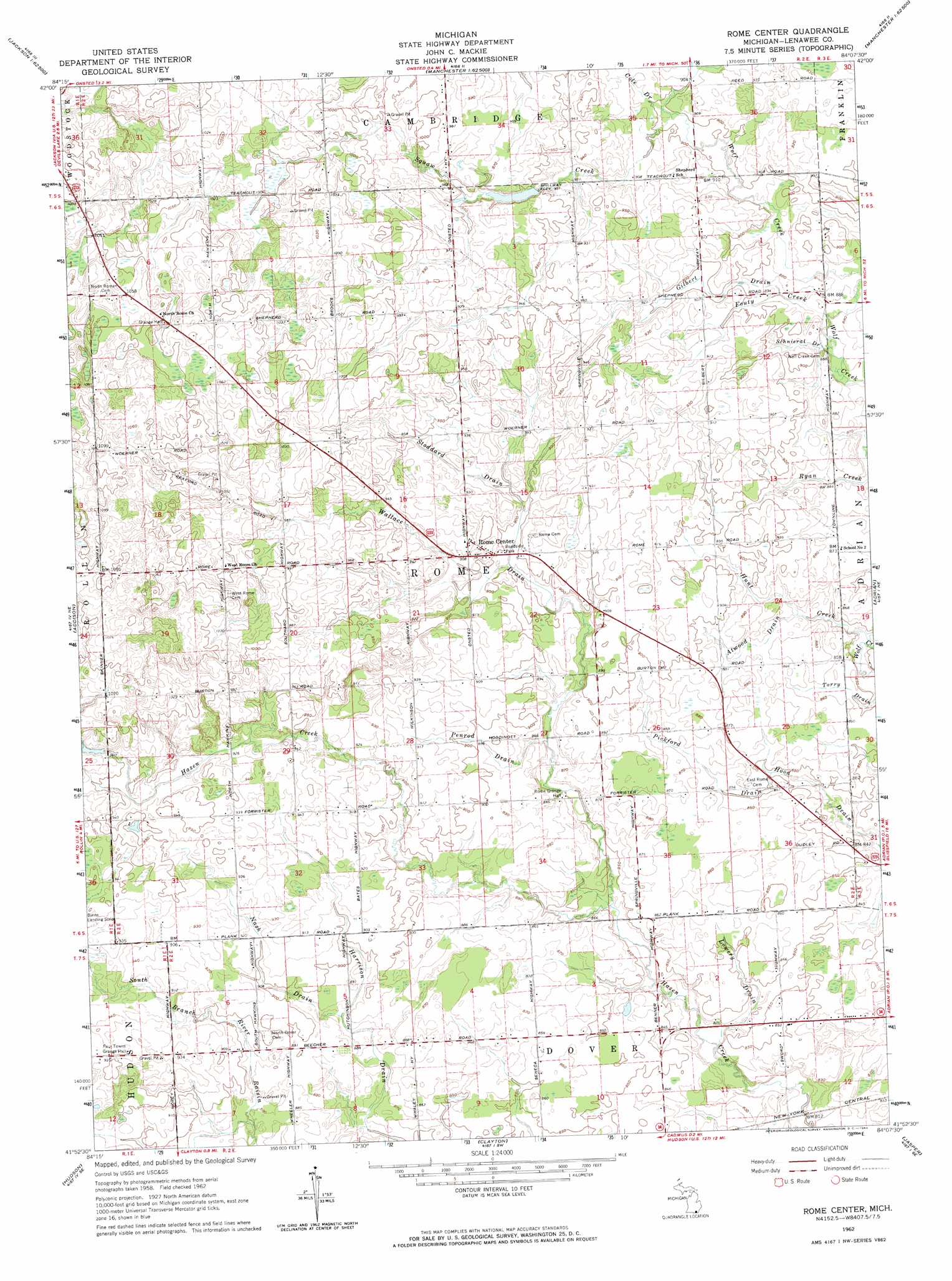
Rome Center Topo Map Michigan
To zoom in, hover over the map of Rome Center
USGS Topo Quad 41084h2 - 1:24,000 scale
| Topo Map Name: | Rome Center |
| USGS Topo Quad ID: | 41084h2 |
| Print Size: | ca. 21 1/4" wide x 27" high |
| Southeast Coordinates: | 41.875° N latitude / 84.125° W longitude |
| Map Center Coordinates: | 41.9375° N latitude / 84.1875° W longitude |
| U.S. State: | MI |
| Filename: | o41084h2.jpg |
| Download Map JPG Image: | Rome Center topo map 1:24,000 scale |
| Map Type: | Topographic |
| Topo Series: | 7.5´ |
| Map Scale: | 1:24,000 |
| Source of Map Images: | United States Geological Survey (USGS) |
| Alternate Map Versions: |
Rome Center MI 1962, updated 1964 Download PDF Buy paper map Rome Center MI 2011 Download PDF Buy paper map Rome Center MI 2014 Download PDF Buy paper map Rome Center MI 2016 Download PDF Buy paper map |
1:24,000 Topo Quads surrounding Rome Center
Jackson South |
Michigan Center |
Norvell |
Manchester |
Bridgewater |
Somerset Center |
Cement City |
Onsted |
Tipton |
Tecumseh North |
Wheatland |
Addison |
Rome Center |
Adrian |
Tecumseh South |
Pittsford |
Hudson |
Clayton |
Jasper |
Palmyra |
Alvordton |
Fayette |
Morenci |
Lyons |
Assumption |
> Back to 41084e1 at 1:100,000 scale
> Back to 41084a1 at 1:250,000 scale
> Back to U.S. Topo Maps home
Rome Center topo map: Gazetteer
Rome Center: Populated Places
Rome Center elevation 277m 908′Rome Center: Post Offices
Dover Post Office (historical) elevation 248m 813′Rome Post Office (historical) elevation 284m 931′
Stoddard Post Office (historical) elevation 326m 1069′
Wolfcreek Post Office (historical) elevation 268m 879′
Rome Center: Streams
Atwood Drain elevation 262m 859′Cole Drain elevation 274m 898′
Fouty Creek elevation 265m 869′
Gilbert Drain elevation 269m 882′
Hunt Creek elevation 254m 833′
Lowery Drain elevation 249m 816′
Nash Drain elevation 268m 879′
Penrod Drain elevation 255m 836′
Pickford Drain elevation 258m 846′
Schnieral Drain elevation 264m 866′
Squaw Creek elevation 273m 895′
Stoddard Drain elevation 272m 892′
Wallace Drain elevation 265m 869′
Rome Center digital topo map on disk
Buy this Rome Center topo map showing relief, roads, GPS coordinates and other geographical features, as a high-resolution digital map file on DVD:
Northern Illinois, Northern Indiana & Southwestern Michigan
Buy digital topo maps: Northern Illinois, Northern Indiana & Southwestern Michigan