Coldwater East Topo Map Michigan
To zoom in, hover over the map of Coldwater East
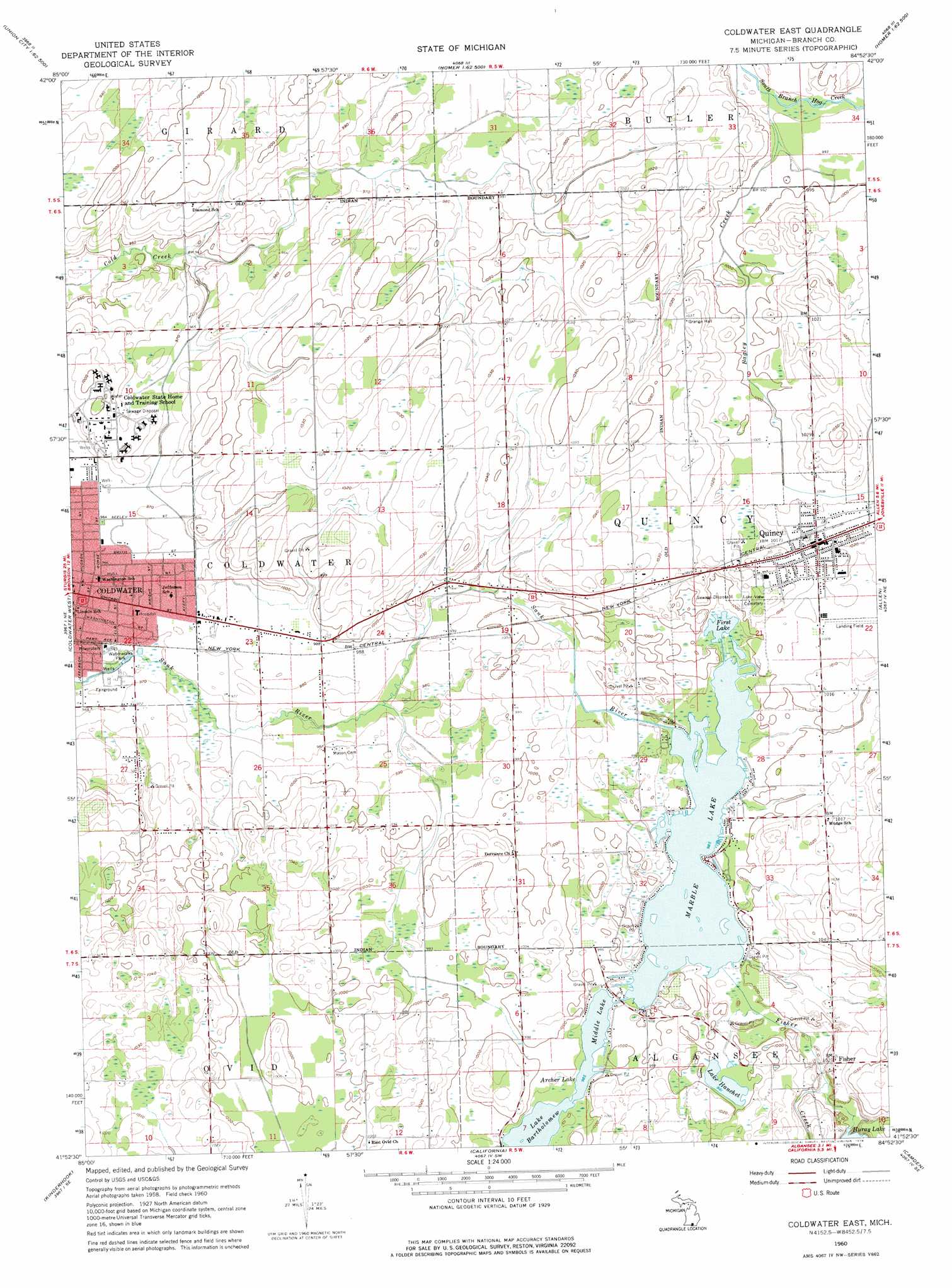
USGS Topo Quad 41084h8 - 1:24,000 scale
| Topo Map Name: | Coldwater East |
| USGS Topo Quad ID: | 41084h8 |
| Print Size: | ca. 21 1/4" wide x 27" high |
| Southeast Coordinates: | 41.875° N latitude / 84.875° W longitude |
| Map Center Coordinates: | 41.9375° N latitude / 84.9375° W longitude |
| U.S. State: | MI |
| Filename: | o41084h8.jpg |
| Download Map JPG Image: | Coldwater East topo map 1:24,000 scale |
| Map Type: | Topographic |
| Topo Series: | 7.5´ |
| Map Scale: | 1:24,000 |
| Source of Map Images: | United States Geological Survey (USGS) |
| Alternate Map Versions: |
Coldwater East MI 1960, updated 1961 Download PDF Buy paper map Coldwater East MI 1960, updated 1976 Download PDF Buy paper map Coldwater East MI 2011 Download PDF Buy paper map Coldwater East MI 2014 Download PDF Buy paper map Coldwater East MI 2016 Download PDF Buy paper map |
1:24,000 Topo Quads surrounding Coldwater East
East Leroy |
Ellis Corners |
Lyon Lake |
Southwest Albion |
Southeast Albion |
Union City |
Burlington |
Tekonsha |
Litchfield |
Mosherville |
Bronson North |
Coldwater West |
Coldwater East |
Allen |
Hillsdale |
Bronson South |
Kinderhook |
California |
Camden |
Reading |
Orland |
Angola West |
Angola East |
Clear Lake |
Nettle Lake |
> Back to 41084e1 at 1:100,000 scale
> Back to 41084a1 at 1:250,000 scale
> Back to U.S. Topo Maps home
Coldwater East topo map: Gazetteer
Coldwater East: Airports
Community Health Center of Branch County Heliport elevation 296m 971′Coldwater East: Crossings
Interchange 10 elevation 308m 1010′Interchange 13 elevation 299m 980′
Interchange 16 elevation 296m 971′
Coldwater East: Lakes
Archer Lake elevation 300m 984′First Lake elevation 300m 984′
Huray Lake elevation 303m 994′
Lake Bartholomew elevation 300m 984′
Lake Hanchet elevation 302m 990′
Marble Lake elevation 300m 984′
Middle Lake elevation 300m 984′
Coldwater East: Parks
City of Coldwater 1861-1961 Historical Marker elevation 298m 977′Coldwater Regional Center Historical Marker elevation 294m 964′
Quincy Park elevation 307m 1007′
Quincy Public Library Historical Marker elevation 310m 1017′
State Public School at Coldwater Historical Marker elevation 294m 964′
Waterwork Park elevation 298m 977′
Wing House Museum Historical Marker elevation 295m 967′
Coldwater East: Populated Places
Apollo Eleven Mobile Home Park elevation 298m 977′Fairview Estates Mobile Home Park elevation 298m 977′
Fisher elevation 311m 1020′
Lake Region Mobile Home Park elevation 309m 1013′
Lee Villa Mobile Home Park elevation 308m 1010′
Quincy elevation 310m 1017′
Trailtree Village elevation 300m 984′
Coldwater East: Post Offices
Dorrance Post Office (historical) elevation 304m 997′Quincy Post Office elevation 310m 1017′
Coldwater East: Streams
Bagley Creek elevation 301m 987′Fisher Creek elevation 299m 980′
Coldwater East digital topo map on disk
Buy this Coldwater East topo map showing relief, roads, GPS coordinates and other geographical features, as a high-resolution digital map file on DVD:
Northern Illinois, Northern Indiana & Southwestern Michigan
Buy digital topo maps: Northern Illinois, Northern Indiana & Southwestern Michigan